Trout Lake, British Columbia
50.58° N · 117.42° W
Updated 10 September 2026
Save Rady Creek
The Government of British Columbia refused to fund this road for more than a decade, refused it the designation that would have protected it, and now says it is too dangerous to keep. The excavators are re-tendered — bids close 24 September 2026. The public was never asked. So we decided to put the entire storyline on the record in public view.
To be destroyed4,395 m · 91 waypoints in the prescription
Re-tenderedCloses 24 Sep 2026
Public comment periodNone
Still standingAs of 10 Sep 2026
The Government of British Columbia has given five different reasons for destroying this road. Its own documents contradict every one of them.
Jun 2021
“The licensee is walking away.”
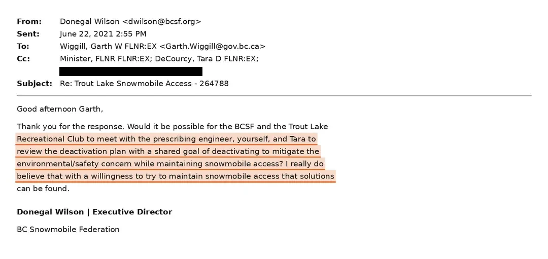
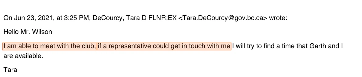
The Regional Executive Director gave a different reason: the district would lose its own access to the road above once the permit lapsed.
May 2021
“This is about caribou recovery.”
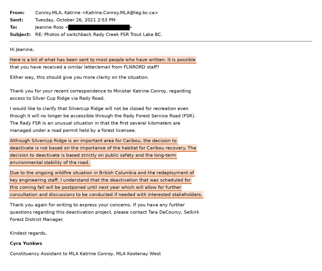
In May 2021 its officer told industry caribou habitat was a priority over access. In October it told the public the decision was not based on caribou.
2026
“There’s no money to maintain it.”
In 2019/20 the Province funded 14% of what its own districts asked for — between 14% and 20% across the three years the Auditor General audited.
2026
“The road is a landslide hazard.”
The Ministry told the public a professional engineer prescribed it. The document names a forest technologist, and the risk is stated for one switchback.
2026
“The public was already consulted.”
There is no comment period on record for this road. The same office ran one for a different road, 30 km away — with mailed notices and a newspaper advertisement.
The excavators are re-tendered, with bids closing 24 September 2026 — to proceed without public consultation. We are asking for a pause, because this government did not follow its own process and decided behind closed doors.
Every record we FOI will be published on this page — the emails, the briefing notes, the government’s own numbers. Let’s get into it ↓
01 — The road
What is about to be destroyed
Rady Creek is a single-lane road that leaves Highway 31 east of Trout Lake and climbs. In under an hour it lifts you from the valley floor to fifteen hundred metres of alpine on Silvercup Ridge. It is beautiful alpine.
Miners cut the first grade here more than a century ago to reach the Silver Cup mine, which pulled roughly a million and a half ounces of silver out of this mountain between 1895 and 1915. The ore ran out and the town emptied — a thousand people in 1897, seven by 1959. The road stayed, and people kept using it.
Today it carries dirt bikes, ATVs, mountain bikers, hikers and horseback riders through the summer. In winter it is the primary safe route into the riding area locals call Foggy Day. It reaches some of the oldest active mineral claims in the province. And it serves what is left of Trout Lake — a community whose three remaining industries are tourism, mineral exploration and recreation. All three go up this road.
It is also the middle of only three ways onto Silvercup Ridge. An old miner-built pack trail runs the length of that ridge. Take out the centre access and anyone in trouble up there has to reach one of the far ends, or wait for a helicopter.
Rady Creek is the central of three routes onto Silvercup Ridge, and the only one scheduled for removal. Remove it and anyone in difficulty on the crest must travel the full length of the ridge to reach the west or east access, or wait for a helicopter.
Valley floor to alpine in under an hour
Schematic elevation profile. The section inside the dashed box is the upper 4,395 metres — 0.0 to 4.395 km in the prescription — that the Province intends to remove, climbing to the height of land where the prescribed work begins and the Silver Cup Ridge Trail starts.
Who built it
This is not a logging spur. The route onto the ridge was surveyed and built as public works, and the Province recorded it at the time — in a report it wrote, printed and published itself.
ReportMineral Resources of the Trout Lake Mining Division · Newton W. Emmens, M.E. · Minister of Mines, 1914 · p.33Source ↗
“an excellent piece of work and a credit to the British Columbia Government, by whom it was built.”
The 1914 survey describes the trunk trail from Trout Lake to Six-mile creek, “thence by a series of long switchbacks on an easy grade past the Winslow mine on to the summit of the Silver Cup ridge” — the same switchbacks now scheduled for full re-contour. The 1934 report returns to the ridge and records the Foggy Day group at the head of the South fork of Brown creek, and prospecting carried on by Mrs. Jowett — Alice Jowett, whose memorial still stands up this road.
Who uses it
Trout Lake held over a thousand people when the Silver Cup was producing. By 1959 there were seven. The people who stayed are the ones who have kept this road open.
The Trout Lake Recreational Club told the Ministry in November 2025 that it was in its tenth year, with “over 300 members at times” — the club’s own count, which no independent record confirms. ↗ It is not a lobby group and it employs no one. It is the body that holds the Wildlife Act permit for the Central Selkirk Snowmobile Management Area, which is how anyone rides here legally — members buy into the club, and the club carries the permit, the insurance and the obligations that come with it.
It also carries the work. In its Section 57 application the club set out what maintaining this corridor actually costs, in volunteer hours rather than dollars: inspection and drainage checks each spring and fall, hand-digging and clearing cross drains, brushing and debris removal, signage and hazard repair. Between thirty and forty hours a year on brushing alone. That was the offer the Province refused.
And the club has quietly covered things well beyond the road. The internet at the Trout Lake hall — the only connection in a valley with no cell service — was put in so that visitors could buy a club membership on arrival in town. The Ministry paid for it for the first couple of years; in 2021 the club took over the bill, and has carried it since.Trout Lake Recreational Club, 4 September 2026 — the club’s own account. We hold no document on the hall connection.
They are joined by the Arrow Lakes ATV Club and the Four Wheel Drive Association of British Columbia, both of which have completed Section 57 authorisations of their own elsewhere, and by the BC Snowmobile Federation. This is who the road belongs to: a handful of people in a valley of seven-hundred-odd — just over fifty of them full-time residents of the village of Trout Lake at the foot of the road — doing unpaid work on public infrastructure the Province stopped maintaining more than a decade ago.
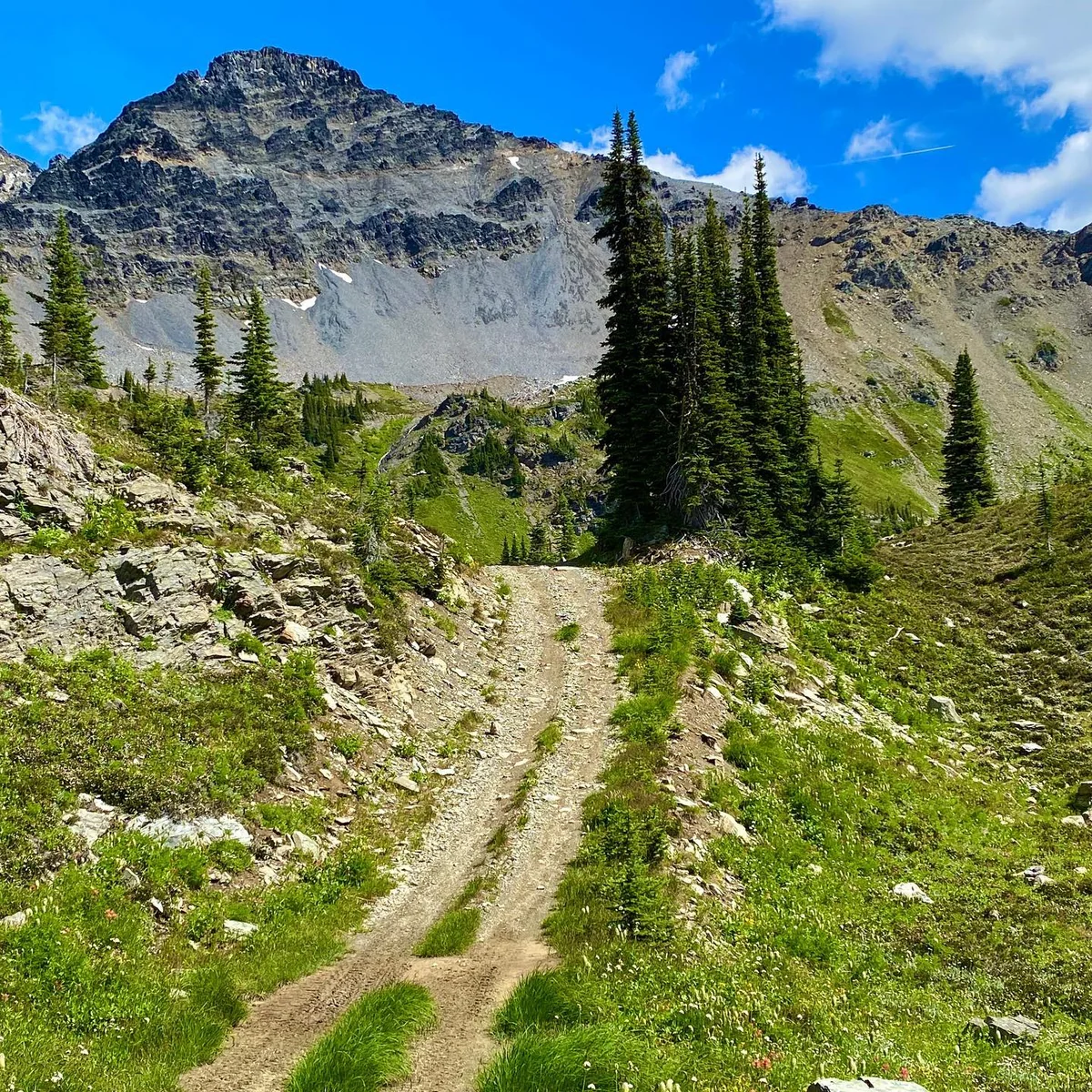
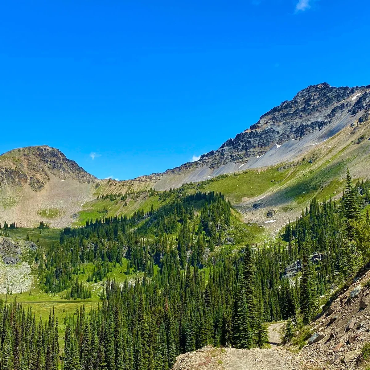
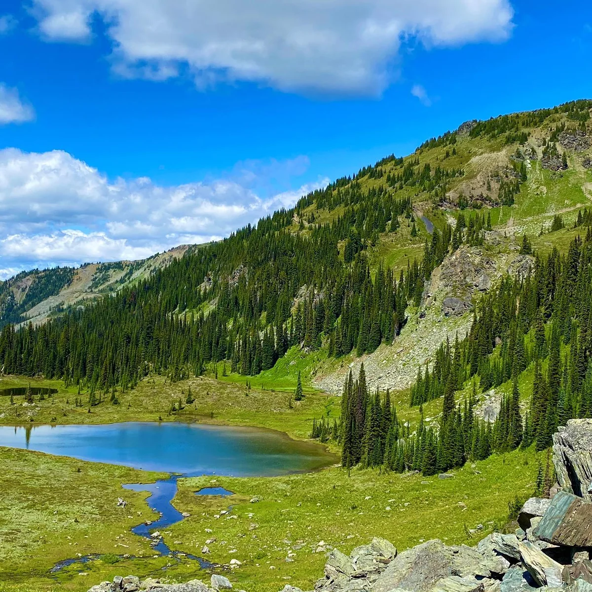
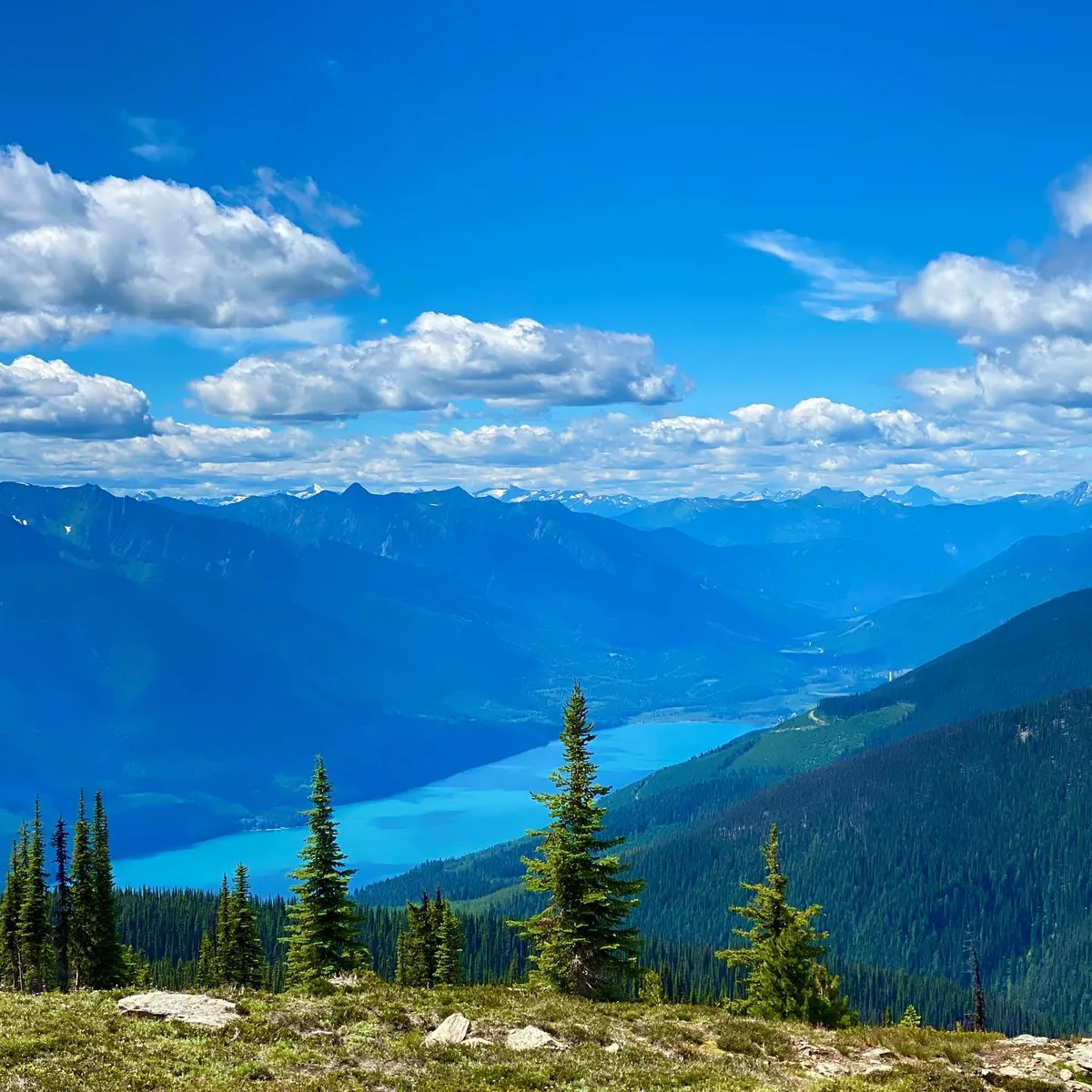
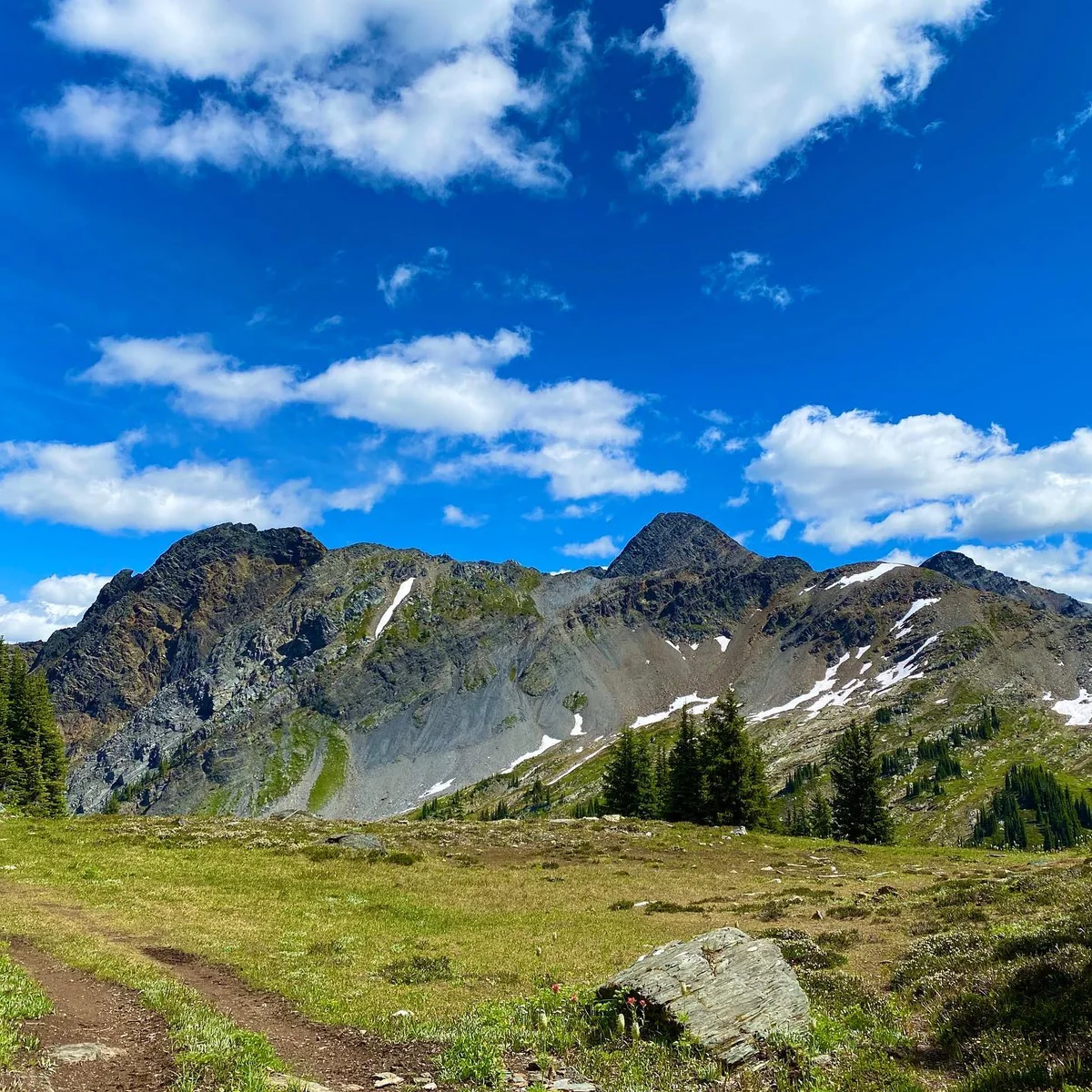
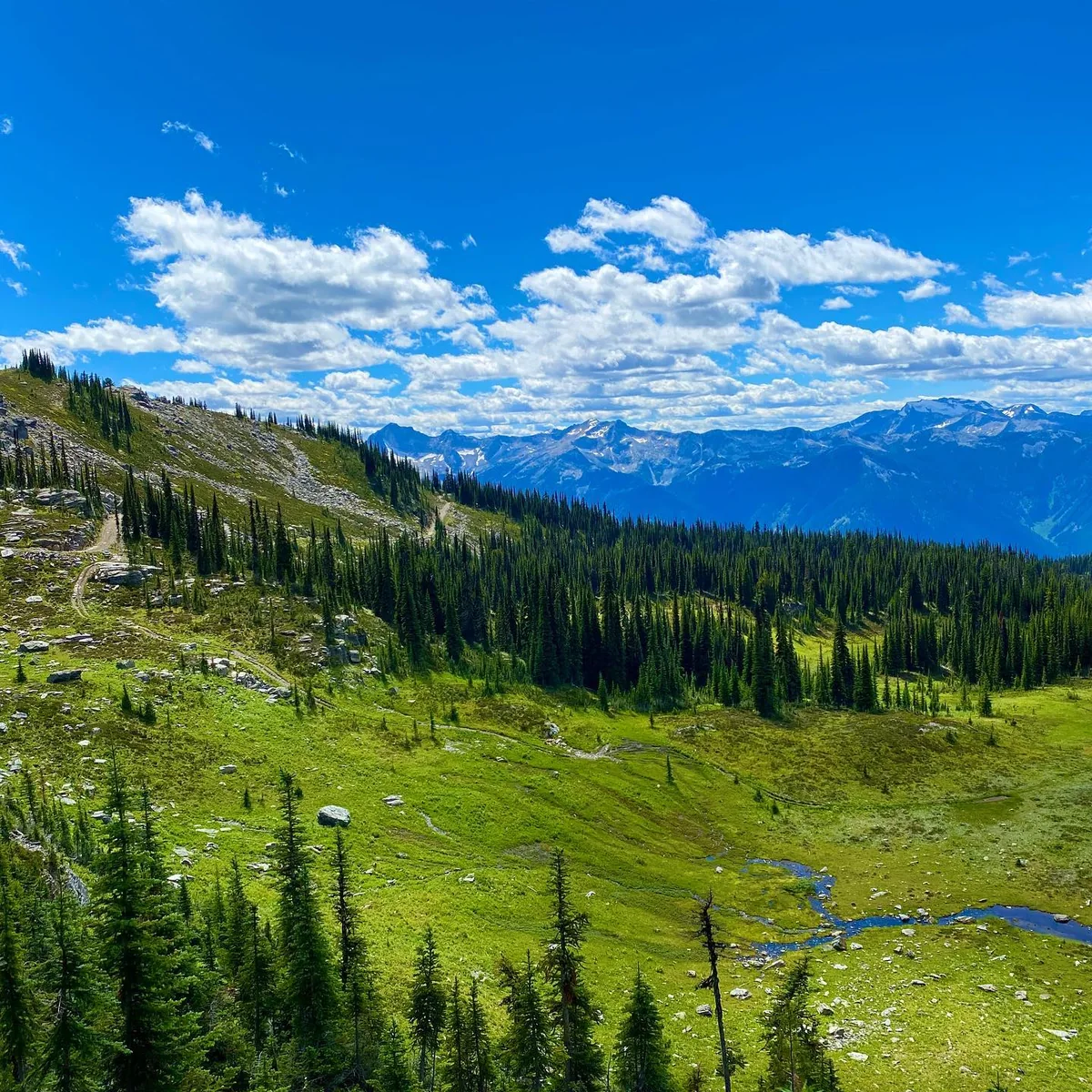
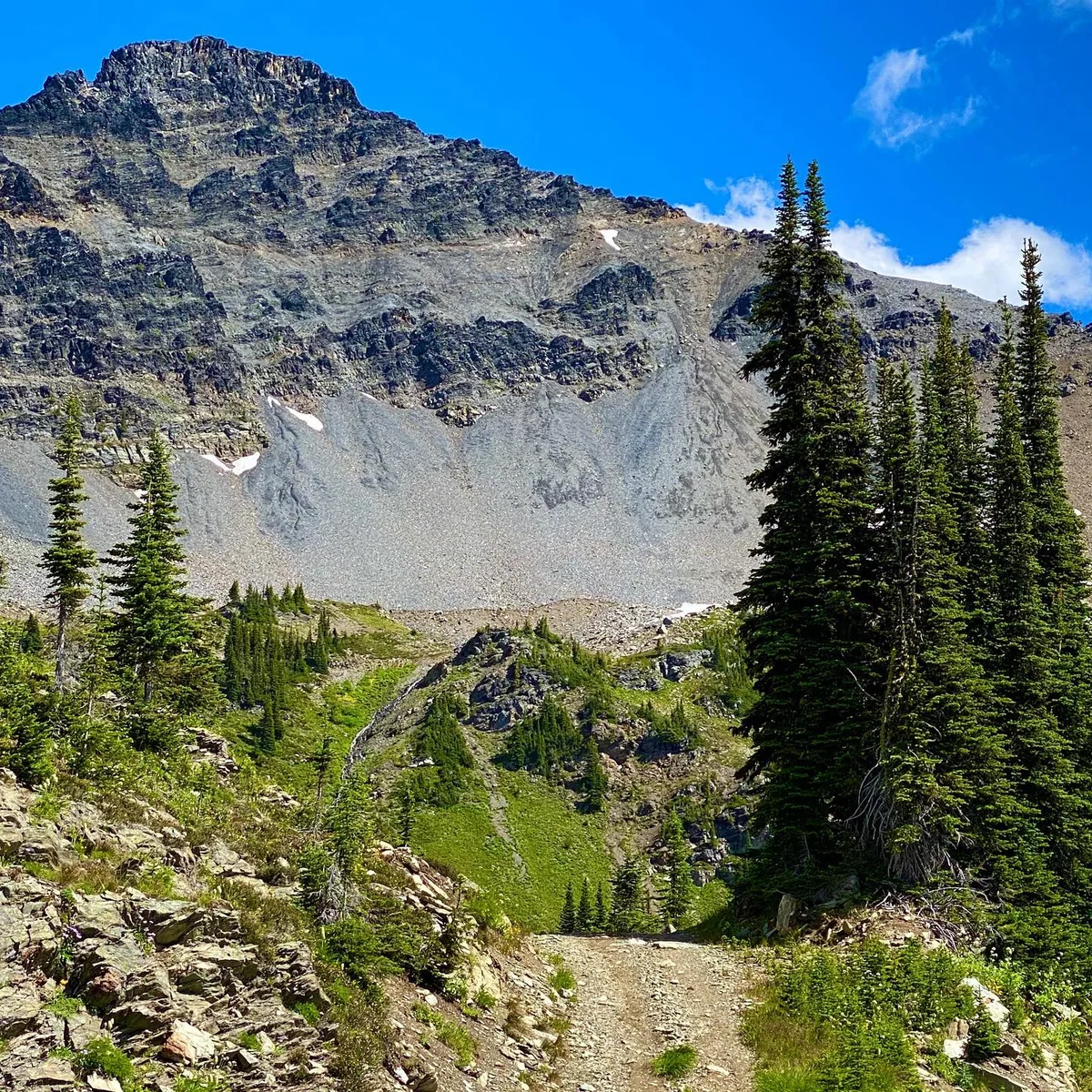
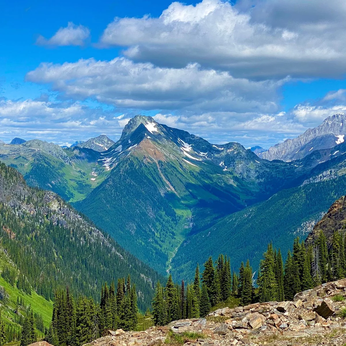
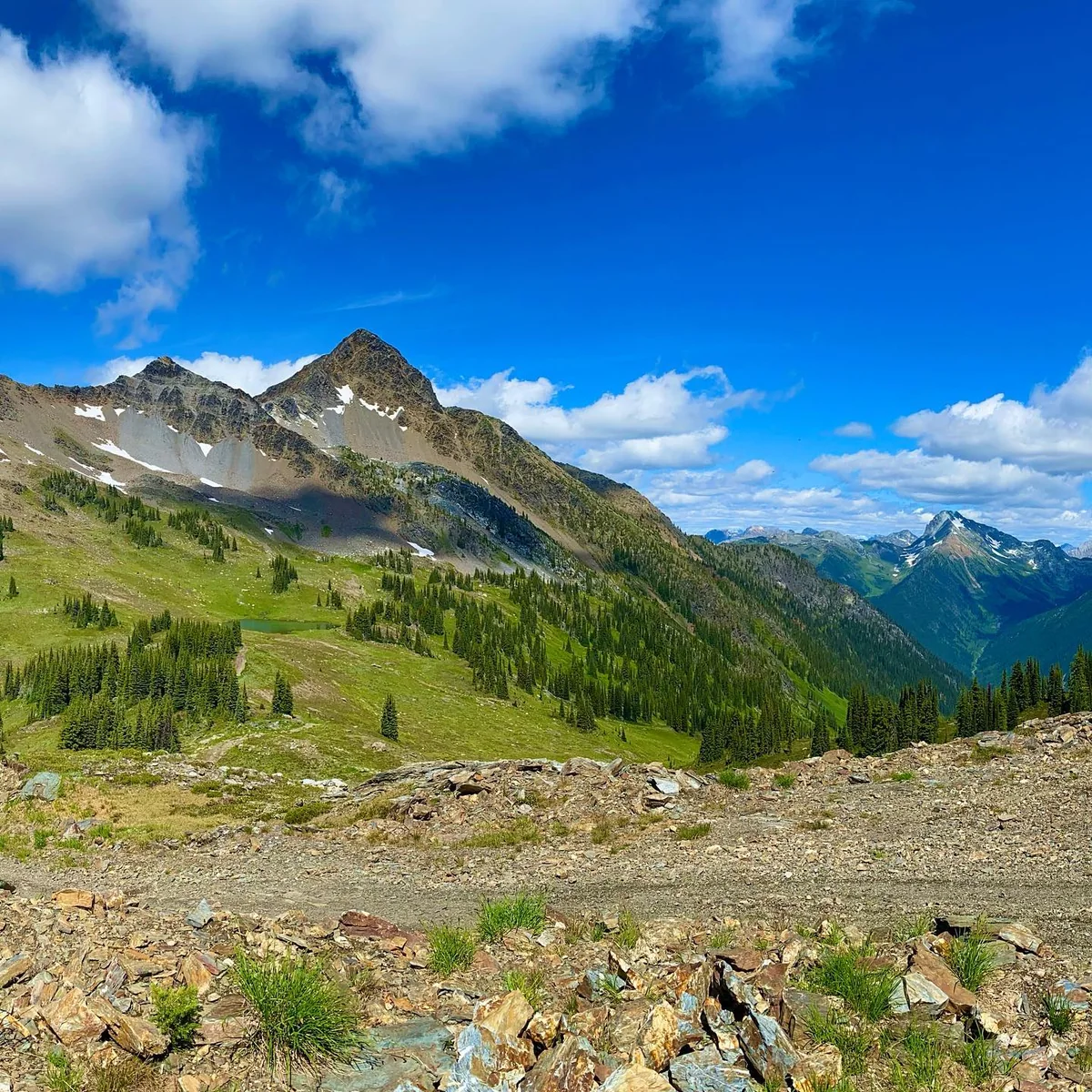
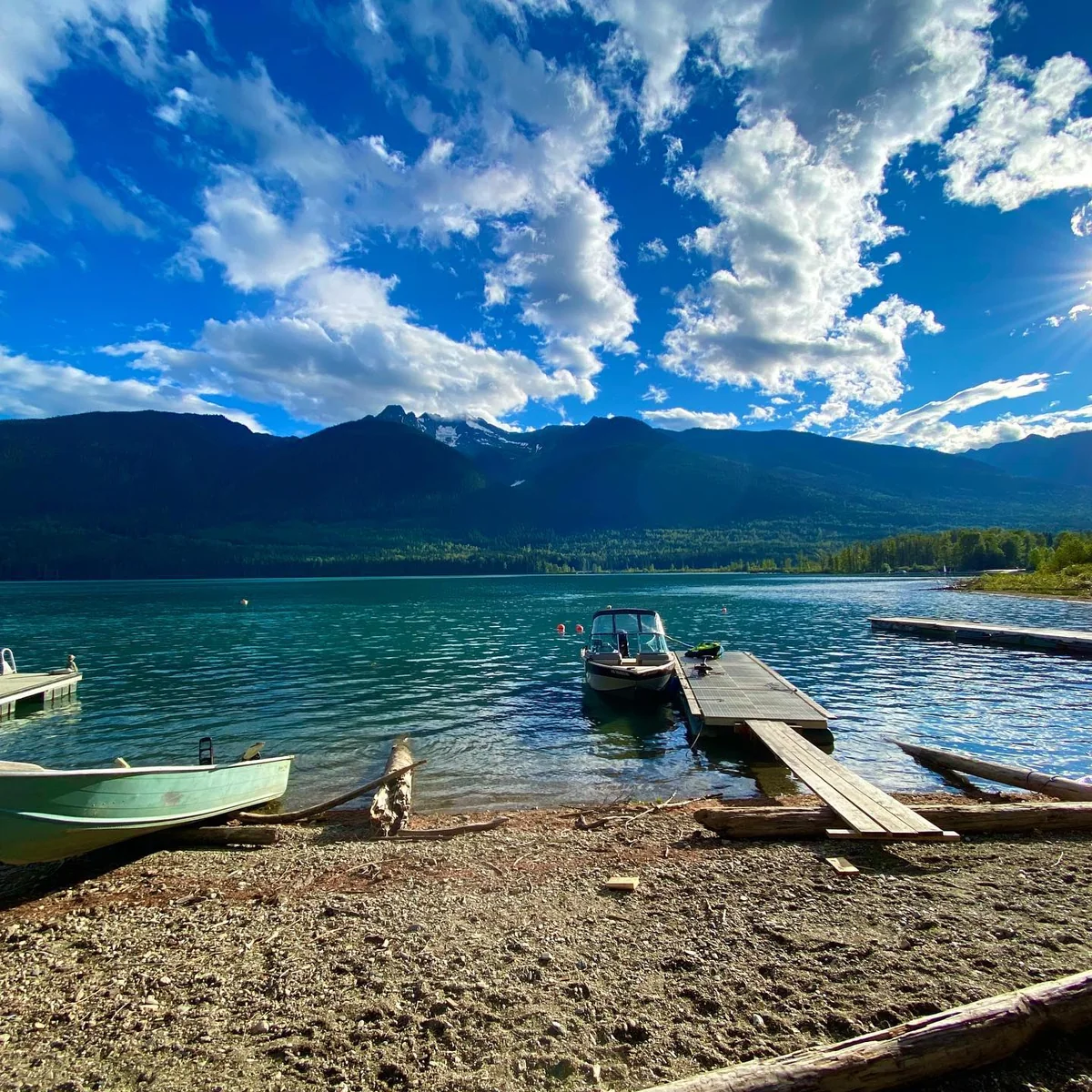
The road itself. Two-track climbing to the alpine ridge. This is the surface the Province calls too dangerous to keep.Rady Creek road bed. A switchback bend dropping back into timber.The tarn below the ridge. Alpine meadow and open water at the top of the road.Trout Lake from the ridge. The valley and the lake, from the ground this road reaches.Across the meadow. The two-track running out to the ridge.The bench traverse. The road cut across an alpine bench, the Selkirks beyond.Below the scree bowl. Road bed under the headwall.The peak above. What sits above the last kilometre.High gravel landing. Near the height of land, where the prescribed work begins.Trout Lake. The community at the bottom of the road.
The Rady Creek road and the country it reaches. Photographs by the Trout Lake Recreational Club, used with permission.
The Trout Lake Recreational Club mapped it, and took the maps to the agency
For years the club built and recorded this trail network alongside the agency that manages recreation on Crown land. In 2017 it took its maps to that agency and asked to have the routes made official.
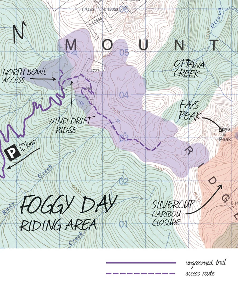
The Foggy Day riding area. Rady Creek runs down the left edge, with the parking marker 10 km along it — this road is the way in. The Silvercup caribou closure is the shaded ground to the east. Map published by SledderMag, June 2021.
The Trout Lake Recreational Club maintains its own trail network and its own mapping of it. In 2017 the club went to Recreation Sites and Trails BC to have the areas it uses made official. On the club’s account a mapping team came out to Trout Lake, the two mapped the ground together, and the club gave the agency a full list of every route it rode and maintained. Nothing released to us shows the agency asking for that list. Trout Lake Recreational Club, in the film at 5:16–5:34. ↗
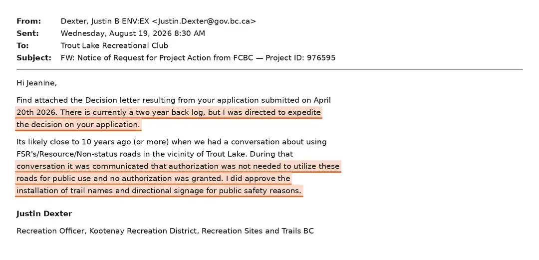
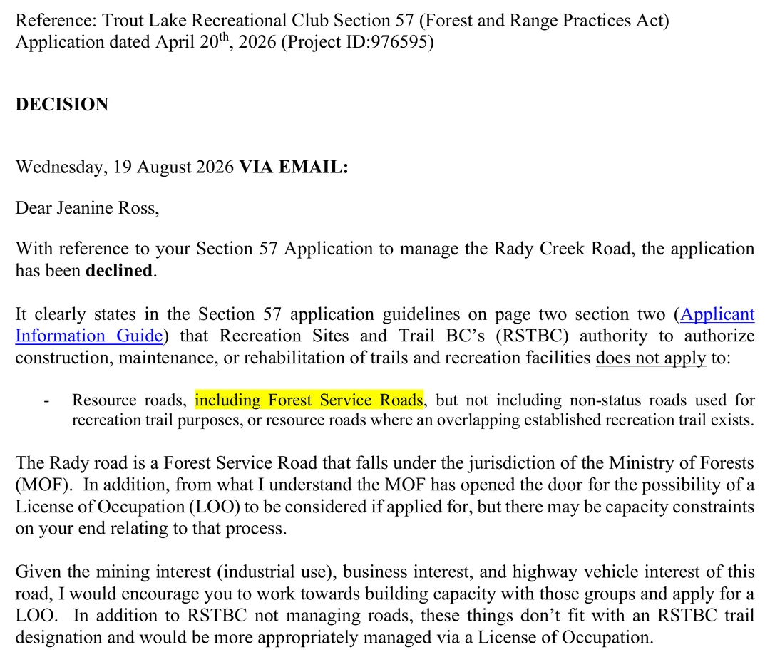
By the club’s account, that exchange came with something in return: permission to operate its network, and signage for it. The club says it asked for those signs and that they were the province’s first of a new design — “We were the very first club to ever get these. I drove to Nelson and got them for our club.” The recreation officer, asked about it in 2026, confirms the approval, though not the claim to be first: “I did approve the installation of trail names and directional signage for public safety reasons.” The club understood the mapping as the first step toward the thing the funding policy actually requires — formal trail designation, the one classification that would have made this road eligible for maintenance money. Trout Lake Recreational Club, in the film at 5:43 and 5:56. ↗ · RSTBC, 19 August 2026. ↗
The designation never came — and eventually the road the club had just mapped was scheduled for deactivation. No referral to the agency holding those maps, and no reply from it, appears in anything released to us — though a stakeholder submission shown in the documentary quotes the Ministry as saying referrals were sent to it and that no comments came back. We hold the film, not that letter; what it does and does not establish is set out in the questions.
The 2017 trail list, the mapping records and the referral letter are the subject of two of the fifteen requests published here. None has been released. This account is the club’s, and we publish it as theirs until the records are produced.
In winter it is the way into Foggy Day
The riding area on that map is not reachable any other way once the snow comes.
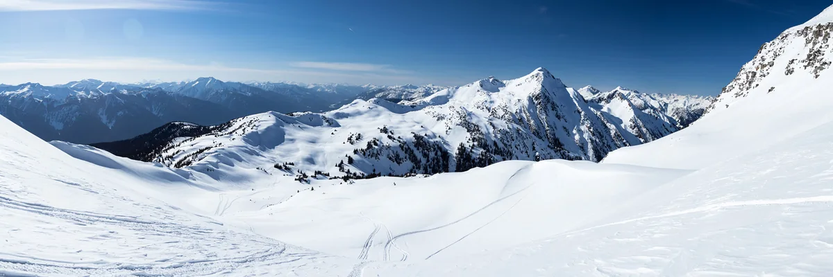
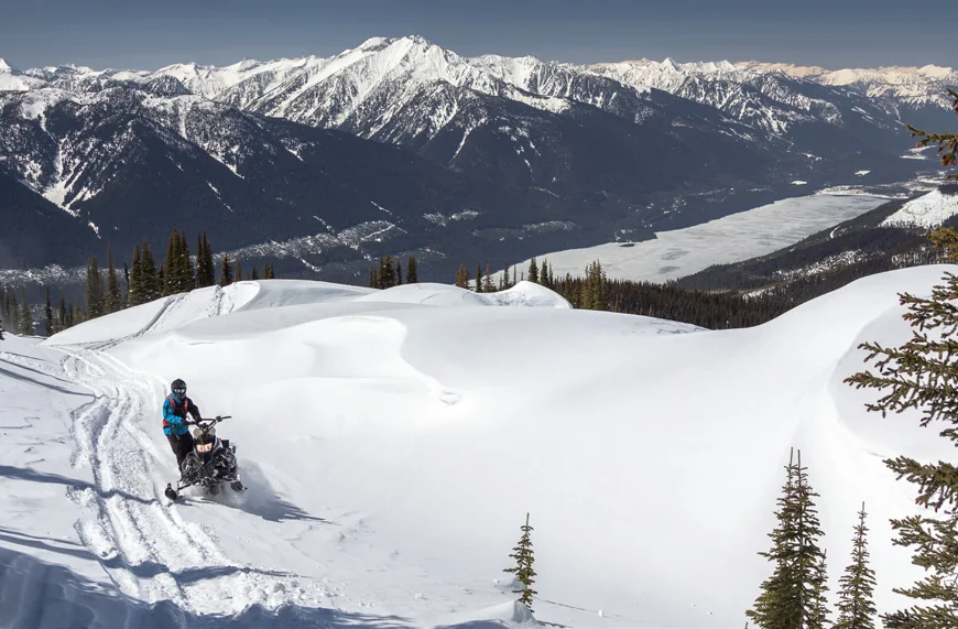
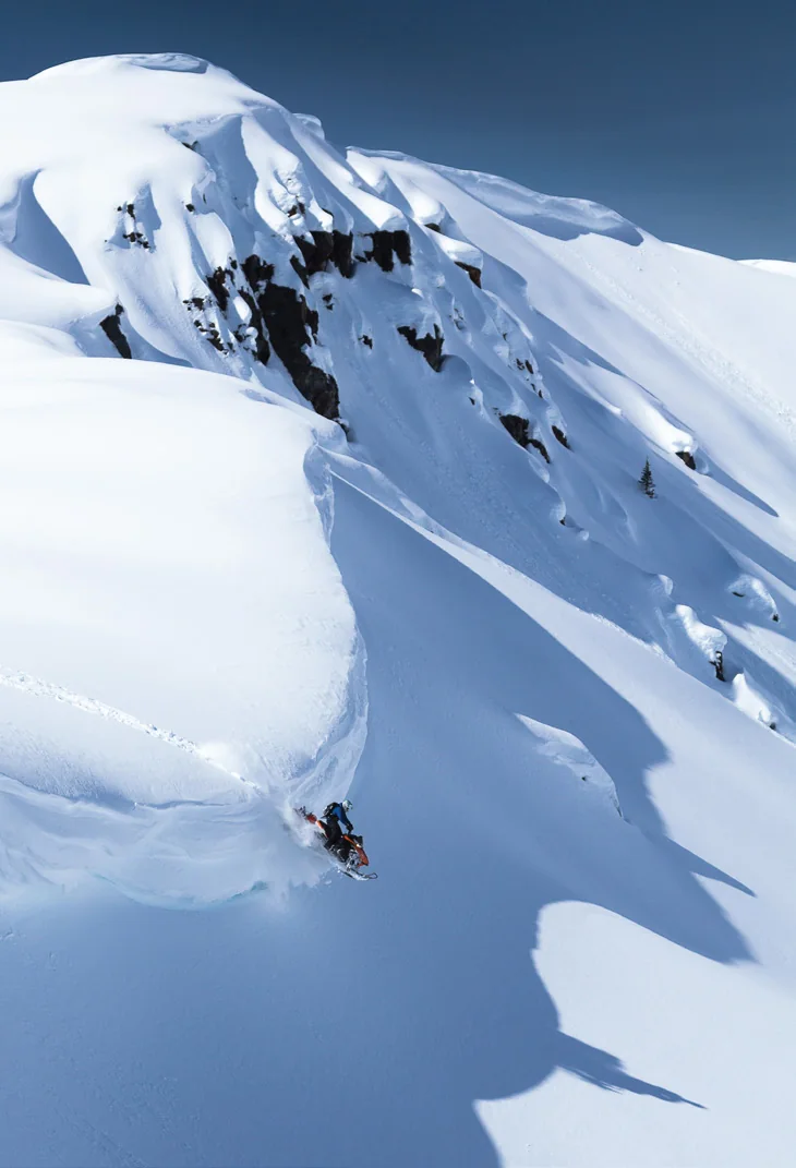
The Foggy Day bowl. Open terrain at the top of the road.Above the valley. Trout Lake from the ridge in winter.Winter alpine. The ground the Rady road is the safe route into.Below the ridge. Riding terrain inside the area.Silvercup country. The high ground beyond.Winter access. Reached only by this road.
Photographs published by SledderMag, June 2021.
The Ministry of Forests says this road has to go. Over five years it has given five different reasons: a licensee walking away, public safety, funding, caribou habitat, and the end of logging. The reasons change depending on who asks. The documents do not.
02 — The money
The Province stopped paying to maintain the road, then called it a hazard
In November 2020 the Auditor General of British Columbia audited how the Province manages its forest service roads. The conclusion was that the Ministry was not maintaining them to its own policies — and the audit explains exactly why.
Every year the natural resource districts — the people on the ground who inspect these roads and know what they need — submit maintenance budget requests. Every year the Engineering Branch funds a sliver of them.
The scale is worth holding in mind. British Columbia has roughly 58,000 kilometres of forest service road. About 30,000 of those are maintained by industry under road use permits, and another 20,000 sit inside BC Timber Sales, which the audit describes as a self-financing programme. What is left is what the districts have to ask for — and only about 12,000 kilometres of it carries the classification the Ministry calls a capital road.
Then narrow it to this region. The South Area, which contains the Selkirk district and Trout Lake, asked for $4.5 million for its priority roads in 2019/20 and received $1.7 million. The single largest slice of what it asked for was recreation access.
The record-keeping was worse than the money. Of eight districts the auditors sampled, seven kept no historical inspection data. Two kept no maintenance records at all. An internal ministry audit had found the same failures in 2008 — twelve years earlier. Nothing had changed in between.
So let’s look at the data in the report.
“[The Ministry of Forests] … did not manage safety and environmental risks in accordance with its policies.”
The Auditor General of British Columbia · Management of Forest Service Roads, November 2020
Requested by districtsAllocated by Engineering Branch
Auditor General of BC, Exhibit 8. Requests rose 41% in three years. The allocation never moved.Auditor General of BC, Exhibit 9. Recreation access was 69% of this region's entire capital-road request for the year.Auditor General of BC, Management of Forest Service Roads, November 2020 — exhibits 4–6 and pp.35, 38, 40. The $8.9M covers high-priority maintenance on priority capital roads in 2019/20.
So what changed after the audit?
The Ministry was invited to respond inside the report. It did.
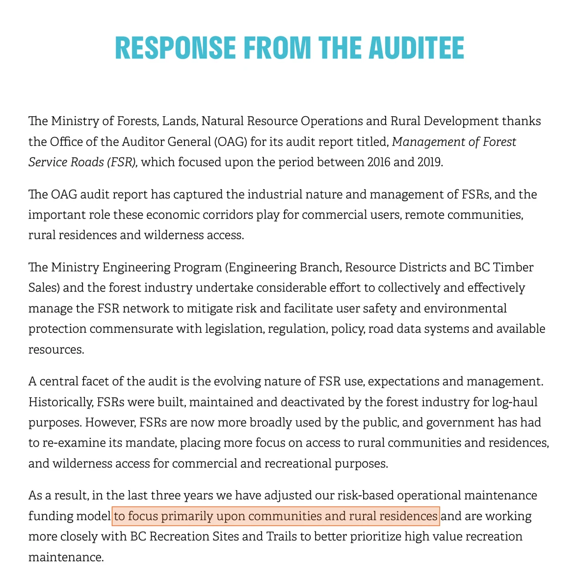
AuditResponse from the Auditee · Ministry of Forests, Lands, Natural Resource Operations and Rural DevelopmentSource ↗
“…we have adjusted our risk-based operational maintenance funding model to focus primarily upon communities and rural residences.”
Communities and rural residences are tiers one and two. Recreation is tier three — the only tier Rady could ever have qualified under.
In the same response the Ministry accepts that “FSRs are now more broadly used by the public” and that it has had to re-examine its mandate to take in “wilderness access for commercial and recreational purposes.”Told it was not maintaining these roads, it moved recreation further down the list.
So which roads get the money?
The Ministry's funding policy ranks maintenance money in three tiers. First, roads serving communities of fifty or more year-round residents. Second, roads serving rural residences. Third — and this is the one that matters — high-value recreation sites, as designated by the Recreation Sites and Trails BC representative.
Roads that clear any tier become what the Ministry calls capital roads. The Auditor General describes capital roads as unlikely to be deactivated, and as requiring continual maintenance. That protection covers the twelve thousand kilometres of capital road counted above.
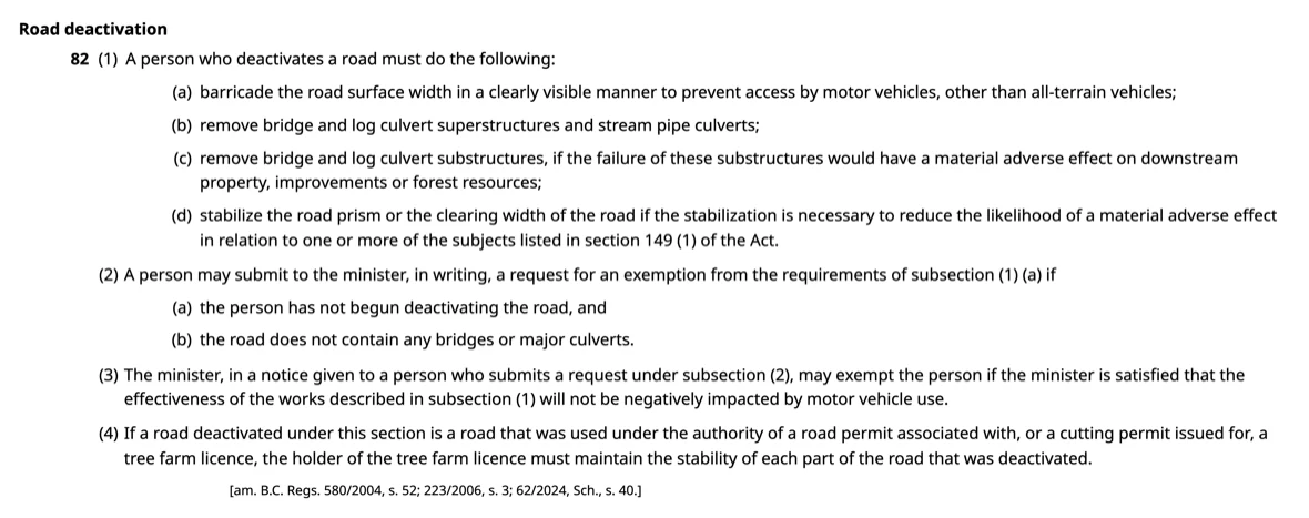
The village of Trout Lake — the community this road serves, not the wider valley — has just over fifty full-time residents on the club’s own count, and about a hundred counting the surrounding communities. Nobody lives on Rady Creek, so tier two never applied. Fifty is also the tier-one threshold — so on the club’s figure Trout Lake sits on the line, not below it. Tier three, high-value recreation, is the tier the club pursued — and it swings on a single administrative decision by a single agency.Population — Trout Lake Recreational Club, 4 September 2026. Trout Lake is unincorporated and has no census population of its own.
What this means
This is not the usual argument about budgets being tight. The people asking for this money were the Ministry’s own staff — the district engineers who walk these roads and write down what they need. Nobody outside government was making the case. The districts said what the roads required, and head office refused them.
Three things follow, all established on the Auditor General’s evidence:
They did not spend the money. Districts asked for $40.2 million in 2019/20 and were given $5.5 million — 14 cents on the dollar, after three years in which the ask rose 41% and the allocation never moved.
They kept no record of maintaining these roads. Seven of the eight districts audited held no historical inspection data. Two held no maintenance records at all. The same failure was found by the Ministry’s own internal audit in 2008, and was still there twelve years later.
So they cannot say what condition any of it was in. That is what the finding above rests on.
The funding policy does not stop there. It tells districts that roads they cannot afford to maintain should be deactivated — so the shortfall does not merely allow removal, it directs it.Engineering Program Funding Policy, quoted at pp.23 and 47
The people who use this road offered to maintain it themselves. The Province said no.
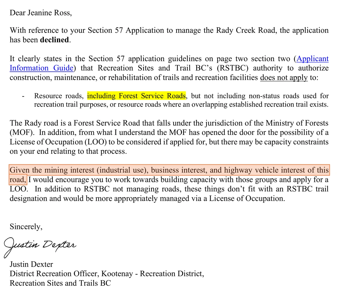
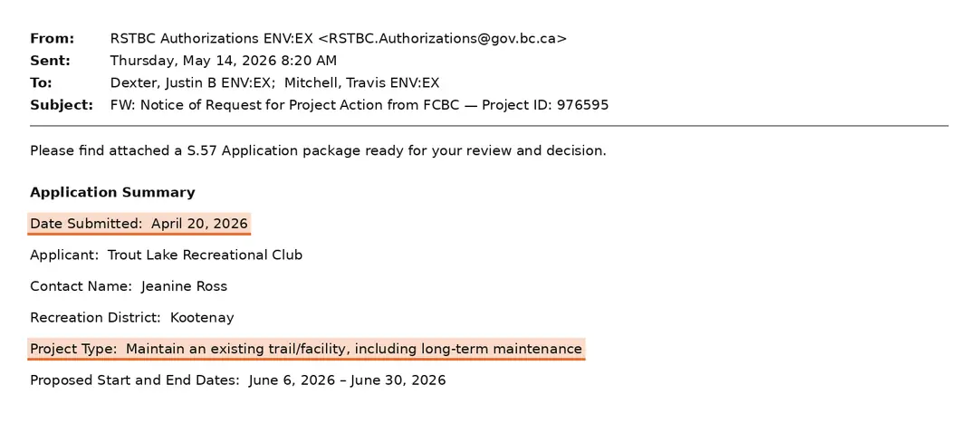
On 20 April 2026 the Trout Lake Recreational Club applied under Section 57 to take on the upkeep of this road. It costed the work in volunteer hours, not dollars: 5–10 hours of inspection and drainage checks each spring and fall, 20–30 hand-digging cross drains, 30–40 brushing and debris removal, and signage as identified. Recreation Sites and Trails BC refused it on 19 August 2026. That is an offer of work, not a log of work done — the club has never held the road permit, and the Province has never funded anyone to maintain this road. What the club does hold is the record below: the obligations it took on through the same years the funding was being refused, and what it gave up when it was asked. When the Ministry wrote to the parties it treated as stakeholders here — five in April 2021, six in May — the club was not one of them.Section 57 application, Trout Lake Recreational Club, 20 April 2026 · decision of Recreation Sites and Trails BC, 19 August 2026.
Trout Lake Recreational Club records, held by the club and provided to us in full.
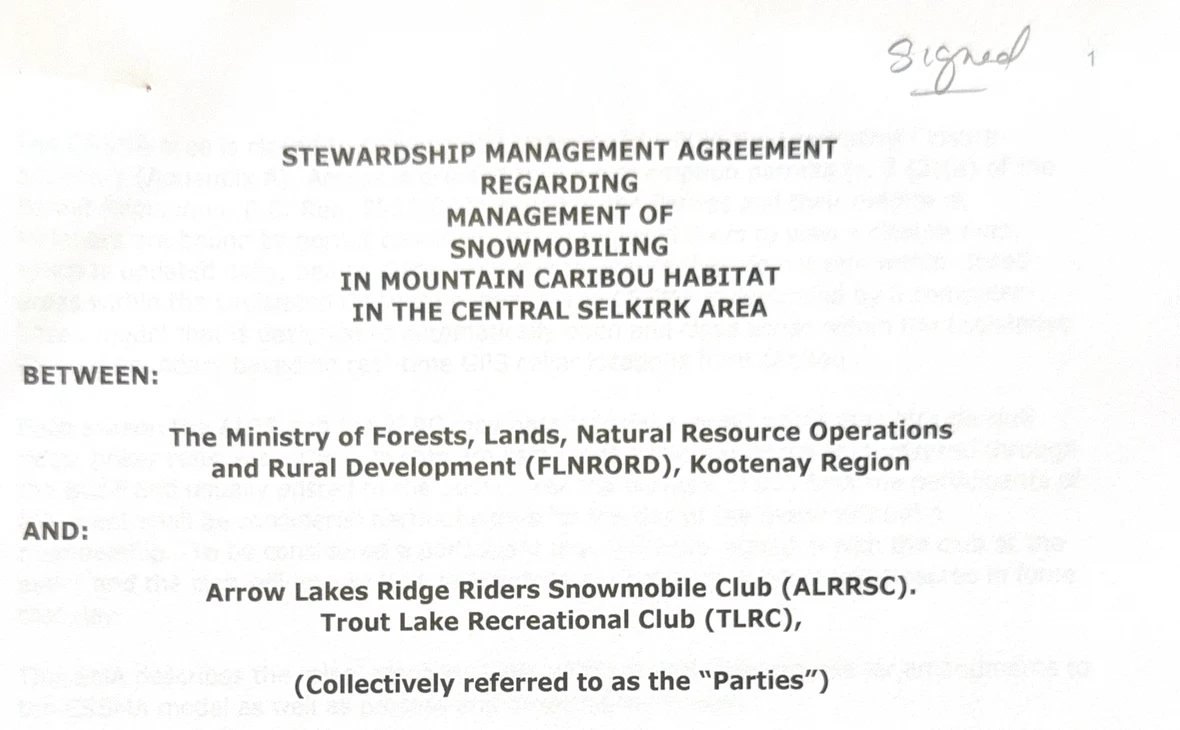
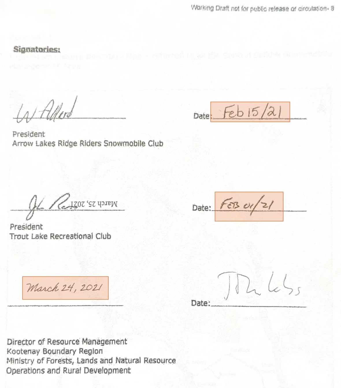
AgreementStewardship Management Agreement · title page and signatures · Central SelkirkSource ↗
Between the Ministry and two volunteer clubs. Nobody else.
The parties are FLNRORD, Kootenay Region, the Arrow Lakes Ridge Riders Snowmobile Club and the Trout Lake Recreational Club — nobody else. This is the agreement under which the clubs gave up riding area in caribou habitat. The clubs signed it in February 2021 — Trout Lake on the 4th, Arrow Lakes on the 15th. The Ministry signed on 24 March 2021, more than a month after them. The club’s copy carries a “Working Draft” watermark; it is the signed copy they hold.
What this means
The Province did not spend the money, did not record the maintenance, and gave up nothing. The club gave up riding area, carried the permit and the insurance, and offered to do the upkeep for free. That offer was refused three weeks before the road was put out to tender for destruction.
Three months after signing that agreement, the club learned the road was to be closed — and not from the Ministry. The Province later said the road’s status was “unknown at the time the SMA was negotiated.”
The club offered to do
that work in volunteer hours, for nothing, and was refused on 19 August 2026.
Three weeks later, on 9 September 2026, the Ministry put the destruction of the
same road out to bid as contract EN27DSE008, closing 24 September. What follows
is that tender — what the Province would not buy, against what it is paying to buy
instead.
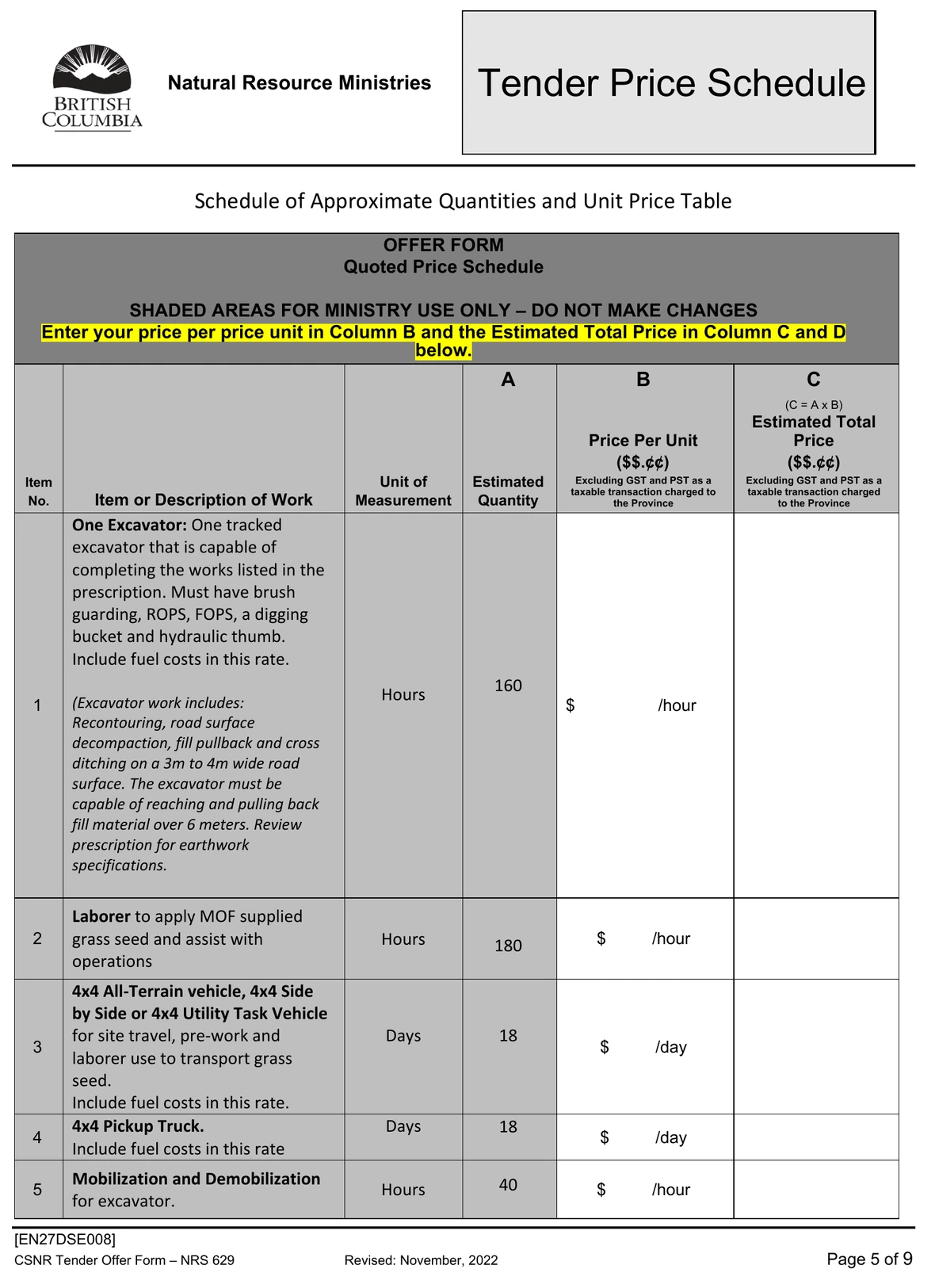
The Ministry’s own tender calls this project “contentious”
The bid package for contract EN27DSE008 was re-issued on 9 September 2026. The tender and the specimen contract attached to it each carry the same finding, in almost the same words. In the tender it opens the description of the work. In the contract it is the first bullet under Safety.
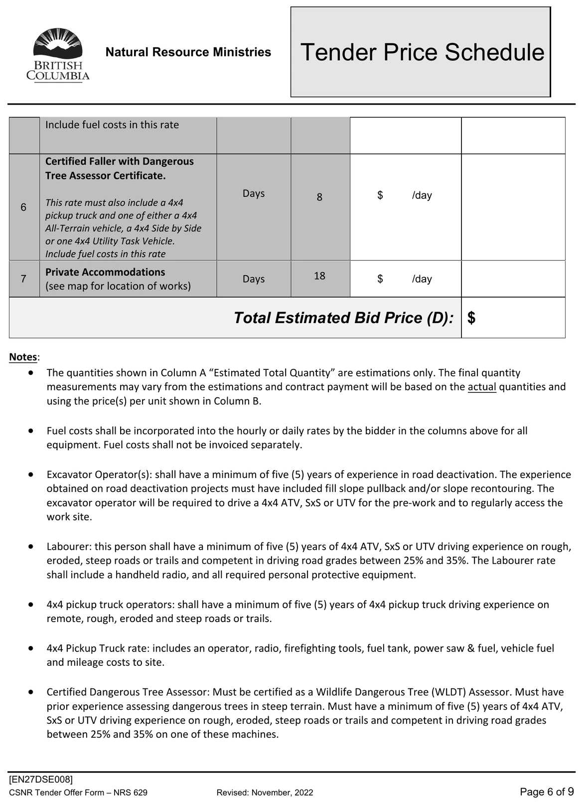
TenderOffer Form · Quoted Price Schedule · contract EN27DSE008 Trout Lake-Rady FSR Deactivation · Offer Form pages 5–6 of 9 · issued 9 September 2026, closing 24 September 2026Ministry of Forests tender package, BC Bid opportunity 233877
“Labourer: this person shall have a minimum of five (5) years of 4x4 ATV, SxS or UTV driving experience on rough, eroded, steep roads or trails and competent in driving road grades between 25% and 35%.”
Every price cell is blank, and so is the Total Estimated Bid Price. This is the blank offer form issued with the tender — not a priced bid and not an awarded contract — so every dollar figure below is built from published rates against the Province’s own quantities. Seven priced rows; the table below takes them one at a time.
The ten-hour day is the specimen contract’s: “Where the Unit of Measure is a day, 10 hours is the equivalent of one day.” Read at that day, the excavator’s 160 hours is sixteen days on the ground, with a further 40 hours billed to move it in and out. The quad, the pickup, the labourer and the accommodation are eighteen days each.
The Province would not fund maintenance on this road and now says it is too dangerous to keep. To close it, it has scoped eighteen days of quad travel on it, and requires the driver to hold five years of ATV, side-by-side or UTV experience on rough, eroded, steep roads or trails and competence on 25% to 35% grades — for works whose prescription header reads “Access Level Remaining after Deact: NO ACCESS”.
One term on the form is defined elsewhere in the same package. “Access Improvement” is “Approximately 5.3km’s of minor road access improvement from Hwy 31 to the bottom of the deactivation site”. The Province will improve 5.3 km of access in order to remove 4.4 km of it.Offer Form — Quoted Price Schedule, contract EN27DSE008, Offer Form pages 5 and 6 of 9, at pages 22–23 of the Tender package issued 9 September 2026 via BC Bid opportunity 233877. The access-improvement definition is in the scope of work in the same package. Quantities are the Province’s.
Estimate · built from published BC rates · the Offer Form itself is unpriced
Fixing the one unstable location costs $9,100–$22,900. Destroying all 4,395 m costs $93,000–$121,000.
Two single payments — not a budget line. The Province’s own deactivation prescription scoped all 4,395 m of this road and, in ninety-three rows, called it unstable in one place — 42 m, stations 1+150 to 1+192. That is 0.96% of the road. Destroying the road costs 6.7× the fix at the midpoints of our estimates — 4.1× on the reading most generous to the Province, 13.3× on the least. Fix instead of destroy and $70,100–$111,900 is never spent. Both figures are priced on the Province’s own published rates, against the schedule it is taking bids on now.
Destroy all 4,395 m$93,000–$121,000→ nothing recoverable
4,395 m removed · permanent
×
Fix the one unstable 42 m$9,100–$22,900→ road still there
42 m fix$16,000
$91,000 unspentat the midpoints
How firm is 6.7×?
4.1×6.7×13.3×
times over. Both bars are drawn at the midpoints, $16,000 against $107,000. The spread is the width of our own rate ranges on both sides, plus the single quantity that is ours — 3–6 machine-days for the fix. Both lanes are the same $107,000. The 42 m, the 4,395 m and every quantity in the deactivation column are the Province’s.
At the end of the top lane the road is gone and the money is gone. At the end of this one the road is still standing, most of the money has not been spent, and the choice to close it later is still available.
B · The fix instead
Quantity × rate
Estimate
Excavator, 6 m reach, operated
30–60 h × $170–$210/hr
$5,100–$12,600
Excavator fuel (invoiced separately)
30–60 h × $40–$65/hr
$1,200–$3,900
4x4 pickup, operated
3–6 d × $920–$1,070/day
$2,800–$6,400
Stabilise 1+150 to 1+192 — estimate
$9,100–$22,900
Table B — the same rates as the deactivation table, over three to six ten-hour days — the only quantity in either table that is ours. The 42 m is the prescription’s. At six days and top rates the fix is $22,900: under a third of the cheapest deactivation estimate. There is no labourer line because the excavator rate is operated; add one at the contract’s own $40–$85 an hour and the fix tops out at $28,000, still under a third of the cheapest deactivation estimate.
This contract was tendered once before. The Ministry issued the same contract number on 10 June 2026 with five priced rows and replaced it on 9 September 2026 with seven. Not one of the five quantities survived: the excavator falls from 200 hours to 160, the labourer from 200 to 180, the ATV and the pickup from 20 days to 18 each, and mobilisation and demobilisation rises from 14 hours to 40 — nearly triple, for a job that got shorter. Fuel changed hands with it. The June form kept excavator fuel off the bid rate, to be invoiced separately against the Province’s Off-Road Equipment Fuel Price Adjustment; the re-issue reads “Fuel costs shall be incorporated into the hourly or daily rates by the bidder… Fuel costs shall not be invoiced separately”, moving fuel-price risk onto the contractor. The table above reads the September schedule, because that is the one bids close on.Tender Price Schedule, contract EN27DSE008, Tender package pages 22–23, issued 9 September 2026 via BC Bid opportunity 233877. The June 2026 Offer Form, pages 1 and 2 of 4, is held on file.
A · Offer Form line — deactivation, tendered 9 September 2026
Quantity × rate
Estimate
1 · Excavator, 6 m reach, operated
160 h × $170–$210/hr
$27,200–$33,600
1 · Excavator fuel — now inside the bid rate
160 h × $40–$65/hr
$6,400–$10,400
2 · Labourer
180 h × $40–$85/hr
$7,200–$15,300
3 · 4x4 ATV, side-by-side or UTV
18 d × $135–$185/day
$2,400–$3,300
4 · 4x4 pickup, operated
18 d × $920–$1,070/day
$16,600–$19,300
5 · Mobilization / demob
40 h × $265–$285/hr
$10,600–$11,400
6 · Certified Faller — the pickup and quad the tender says his rate must include
8 d × $1,055–$1,255/day
$8,400–$10,000
6 · Certified Faller — the person, at the Ministry’s own appraisal rate
8 d × 10 h × $99.12/hr
$7,900
7 · Private Accommodations — crew of 2–3
18 d × 2–3 × $175/person/day
$6,300–$9,500
Destroy all 4,395 m — estimate
$93,000–$121,000
Table A — the schedule the Province is actually taking bids on, closing 24 September 2026. Every quantity is the Province’s, off the re-issued Offer Form. Every rate here is the Province’s own — the wildfire equipment schedule for the machines, the Ministry’s appraisal manual for the faller and the camp. The ten-hour day is the contract’s: clause 1.02 of the specimen contract for this tender reads “Where the Unit of Measure is a day, 10 hours is the equivalent of one day.” Rows are rounded to the nearest $100 and the total to the nearest $1,000 — the rows as printed sum to $93,000–$120,700. One quantity here is ours: the accommodation crew size, because the tender gives 18 days and no headcount. Not in this total — the Dangerous Tree Assessor ticket item 6 also requires, and the contractor’s own overhead, margin and fuel-price risk.
Where the faller and the camp rates come from. Item 6 is eight days of a Certified Faller who also holds a Dangerous Tree Assessor certificate, and the tender says what must sit inside that day rate — it “must also include a 4x4 pickup truck and one of either a 4x4 All-Terrain vehicle, a 4x4 Side by Side or one 4x4 Utility Task Vehicle.” Both machines are priced off the same published schedule as every other row: $920–$1,070 a day for the pickup, $135–$185 for the quad. Eight days of them is $8,400–$10,000 before the faller is paid anything. The 2026 BC Wildfire equipment schedule prices neither the faller nor accommodation — its §1 “Falling” prices feller-bunchers, which are machines — but the Ministry’s own Interior Appraisal Manual prices both, and states they “must be used for all engineering cost estimates”: a “Faller, including powersaw cost” at $99.12 an hour, and $175 a day per person for crew accommodation. Eight days at the contract’s ten-hour day is $7,900; eighteen days of camp for two to three people is $6,300–$9,500. Not in the total: the Dangerous Tree Assessor ticket, for which no published premium exists; the contractor’s overhead and margin; and the fuel-price risk the re-issue moved onto the bidder. All three push the real bid up, not down.Item 6 quoted verbatim from Tender package page 22; the ten-hour day from clause 1.02 of the Specimen Contract for the same tender. Faller and crew-accommodation rates — Ministry of Forests, Timber Pricing Branch — Interior Appraisal Manual, effective 1 July 2026, Appendix I, pages A-7 and A-8. Quantities and rates are the Province’s; the accommodation crew size and the totals are ours.
What this means
This is not a one-time cost set against a yearly programme. Both numbers are single payments. One of them repairs the 42 metres the Province’s own prescription found unstable. The other removes all 4,395 — including the 4,353 metres it did not. Fixing the 42 costs $9,100–$22,900; removing the 4,395 costs $93,000–$121,000.
Nobody is asking the Province to fund this road every year, and it has not been funding it. It stopped, the Auditor General recorded why, and the road has stood through five seasons since the Ministry first proposed to close it in August 2021.Consultation Request Intake Form, 27 April 2021.
So the question is not whether the Province can afford this road. It is whether $93,000–$121,000 should be spent removing 4,395 metres permanently because 42 of them are unstable, when $9,100–$22,900 fixes the 42 and leaves $70,100–$111,900 for the maintenance the districts asked for and did not get.
All of this is an estimate. Every price cell on the Offer Form is blank, so both totals are ours. The arithmetic is in the two tables above — quantity, rate and result on every line — and every rate is linked below.
Footnote — what if the Province did fund upkeep? It does not, and for five seasons it has not. If it did pay contract rates for one season of work on the whole road, our estimate on the same rates is $12,800–$34,000: 2–4 machine-days grading and shaping ($6,000–$15,300), and 2–4 days of machine plus labourer brushing and clearing the cross drains ($6,800–$18,700). Adding that second person takes those rows to $342–$467 an hour, against $210–$275 for the bare machine. Those day counts are ours — the only quantities in this whole block taken from no document at all, which is why they sit in a footnote and not in the comparison above: price maintenance as an annual line and an analyst capitalises it, when the record is that nobody has been billing for it. What the Trout Lake Recreational Club actually offered under Section 57 in April 2026 was 5–10 hours of inspection and drainage checks each spring and fall, 20–30 hand-digging cross drains, 30–40 brushing and debris removal, and signage as identified — in volunteer hours, for nothing. Recreation Sites and Trails BC refused it on 19 August 2026.
The quantities on the Offer Form are the Province’s; the rates and both totals are ours, and every rate below is published, dated and linked. The ATV line, reconciled. §11.1 of the wildfire schedule gives a four-wheel ATV an all-found day rate of $79.71 and then adds a market fuel adjustment for the month — +$55.83 in July, +$61.44 in June — which is $135.54 a day. A four-wheel side-by-side, the unit that can carry the labourer and the tools this contract requires, is $114.20 plus $68.05–$74.89, or $182–$189. Our $135–$185 is that span, end to end. (§11.1 carries its own note that its rates are for use with the Forest Sector Guidelines to Compensation; it is the only ATV line the schedule publishes.) It is priced as equipment only: the schedule’s own operator rate is $83.17 an hour, so a day with a person on the machine adds about $830. A machine-day is one excavator on site for the ten-hour day the tender’s own notes set, with its fuel, plus the 4x4 pickup that gets the crew there: $3,020–$3,820. Priced that way the fix costs $303–$382 for every hour the machine is on the ground, against $210–$275 for machine-plus-fuel in table A — 39–44% above our own machine rate. The labourer is a contract rate, not a wage: Job Bank gives the Kootenay wage for the occupation as $18.27–$39.85 an hour and we carry it at $40–$85 to cover employer costs, supervision and overhead — roughly 2.1×. That multiple is ours and is in neither document. The BC Wildfire schedule sets fire rates, priced for emergency mobilisation; a scheduled summer contract is a different risk, and we cannot say which way that bias runs. It is still the right comparator, because it is built the way the tender is: “All Found Rate means equipment and operator together with all costs and expenses… excluding fuel and lubricants,” with fuel added by a separate monthly adjustment — exactly how the June 2026 Offer Form handled the excavator. That parallel broke on 9 September 2026. The re-issued tender folds fuel into the bid rate — “Fuel costs shall be incorporated into the hourly or daily rates by the bidder in the columns above for all equipment. Fuel costs shall not be invoiced separately” — so the fuel line in table A is no longer a separate invoice item against the Province’s Fuel Price Adjustment but a cost the contractor now carries inside the hourly rate. The machine class is ours. The June 2026 Offer Form specified the excavator by mass — “45,000lbs-67,999lbs (20.41 tonnes to 30.84 tonnes)” — and we chose §7.1 to match it. The 9 September 2026 re-issue states no mass at all. It specifies the machine by capability instead: “One tracked excavator that is capable of completing the works listed in the prescription… The excavator must be capable of reaching and pulling back fill material over 6 meters.” The tonnage that used to label these two tables had no source left, so we have taken it out rather than carry a number no document supports. What stands in its place is the Ministry’s own 6-metre reach requirement, and a rate class we picked ourselves and are naming as ours. Rates — BC Wildfire Service, Ministry of Forests — 2026 BCWS Equipment Rates and Market Fuel Adjustments, 2 August 2026 (§7.1 excavator (guarded), §6.3 lowbeds, §6.4 pickups, §11.1 all-terrain vehicles); Job Bank, Government of Canada — NOC 75110, Kootenay region, wages updated 19 November 2025 (low $18.27 / median $26.95 / high $39.85 per hour). Quantities — Offer Form, Quoted Price Schedule, contract EN27DSE008, pages 1–2. Road figures recomputed by us from the deactivation prescription: 74 cross ditches, 362 m of pull-back (42+140+40+20+30+90), instability at one 42 m location, 1+150 to 1+192.
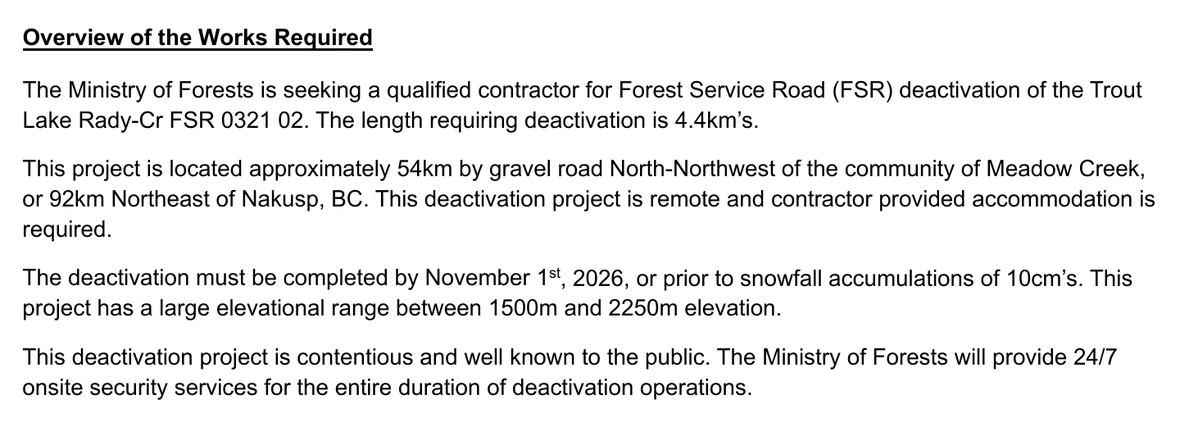
Tender · page 3EN27DSE008 · Information to Bidders · “Overview of the Works Required”BC Bid opportunity 233877, posted 9 September 2026
“This deactivation project is contentious and well known to the public. The Ministry of Forests will provide 24/7 onsite security services for the entire duration of deactivation operations.”
It is the fourth paragraph of the passage that tells bidders what the job is, between the November completion date and the list of works. Contentious is the Ministry’s own word for it, written for contractors rather than for the public. It records that the Ministry expects opposition and has planned around it.EN27DSE008 Tender package, page 3 of the Information to Bidders — the passage is quoted whole in the image above
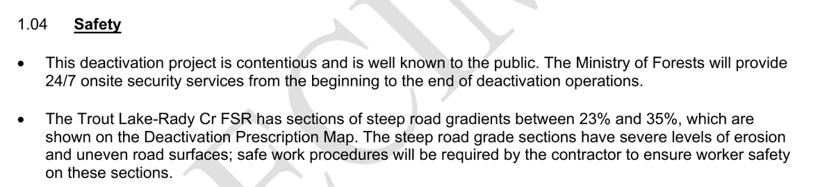
Specimen Contract · page 5Schedule A – Services · clause 1.04 “Safety” · the first two bulletsBC Bid opportunity 233877, posted 9 September 2026
“This deactivation project is contentious and is well known to the public. The Ministry of Forests will provide 24/7 onsite security services from the beginning to the end of deactivation operations.”
The same finding in the document the successful bidder signs — and here it is the first bullet under the heading Safety. The bullet beneath it is about the road: gradients “between 23% and 35%” with “severe levels of erosion and uneven road surfaces.” Public opposition is the first item under that heading; the condition of the road is the second.EN27DSE008 Specimen Contract, page 5, Schedule A – Services, clause 1.04.
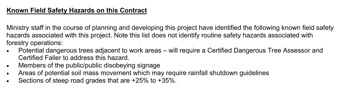
Tender · page 4“Known Field Safety Hazards on this Contract” · all four itemsBC Bid opportunity 233877, posted 9 September 2026
“Members of the public/public disobeying signage”
The hazard list the Ministry gives bidders, complete and in the Ministry’s own order: dangerous trees, the public, potential soil mass movement, and road grades of +25% to +35%. Four items. The second is people.
Working a machine on a steep, eroded road beside people who object to the work is a real safety problem, and a contract that plans for it is a contract doing its job. It is also the Province recording public opposition to its own decision as a field hazard, in a list with unstable ground and dangerous trees, and undertaking to keep security on site twenty-four hours a day for the length of the job.EN27DSE008 Tender package, pages 3 and 4; EN27DSE008 Specimen Contract, page 5, clause 1.04 — the three images above
The Province is providing the security itself, and no bidder prices it
The same sentence names who pays for it. The words are “The Ministry of Forests will provide” — not the contractor. The tender’s price schedule carries no security row, and the two security requirements the tender does name are both switched off.
Tender · page 10Conditions of Tender · paragraphs 6 and 7 — the only two security requirements in the documentBC Bid opportunity 233877, posted 9 September 2026
“6. BID SECURITY REQUIREMENT — 6.01 Not applicable”
Across the twenty-seven-page tender package there are twenty-two mentions of security. Twenty-one of them are money — bid bonds, performance bonds, and the definitions and default clauses that hang off them — and the two that would have applied to this contract are struck out on this page. One is guarding, and it is the sentence above. In the twenty-two-page specimen contract the word appears once in the whole document, and it is that same sentence again.
So the only security this contract involves is people on the ground, the words are “The Ministry of Forests will provide”, and there is no row anywhere in the price schedule for a bidder to quote it on. Round-the-clock security for the length of the works is a cost the Province carries, and it sits in nobody’s bid.
The package states no figure, and a bidder never sees one. What can be said is where it sits: the costing above prices the works, and it does not include this — because the tender does not price it either.EN27DSE008 Tender package, page 10 of the Conditions of Tender, and its Tender Price Schedule at page 22, read in full. Counts run across the whole 27-page tender package and the whole 22-page specimen contract.
Every funding tier turns on one designation, and that designation was a single agency’s to give. The club went and asked.
03 — The bait & switch
One decision sealed the road’s fate
Neither of the first two funding tiers was ever open to this road. The only door left was the third — high-value recreation — and it opened on the say-so of a single agency. The funding policy, the three tiers and what each one requires are set out in 02 — The money.
That agency is Recreation Sites and Trails BC. In 2017 the Trout Lake Recreational Club went to it and asked for exactly the thing the funding policy requires — official recognition of the terrain it rode. A member says it plainly on camera: “We gave Rec Sites and Trails our list of our recreational trails.” The agency’s own recreation officer, writing in August 2026, recalls the conversation and confirms what came of it — signage, but no authorization. Trout Lake Recreational Club, in the film at 8:00. ↗ · RSTBC, 19 August 2026. ↗
What happened over the nine years that followed is the heart of this story.
They decided it wasn't a high recreation value place. We just weren't important.
Trout Lake Recreational Club member, speaking on camera, August 2026
Account of the Trout Lake Recreational ClubWe went to them, and did everything they asked
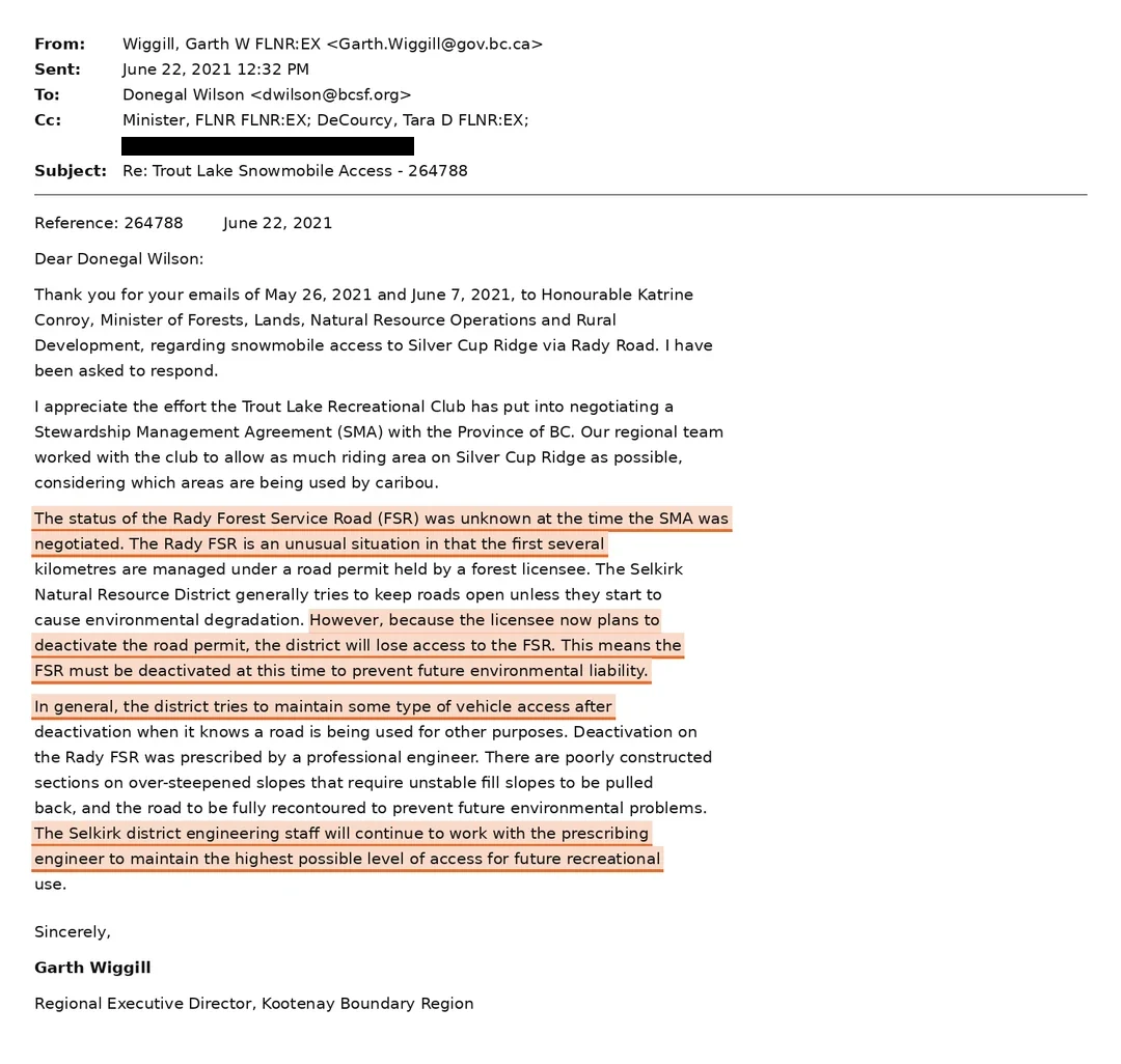
What the Ministry said in 2021
Held by the Trout Lake Recreational Club and provided to us in full. Written three months
after the Ministry countersigned the stewardship agreement, and copied to the Minister.
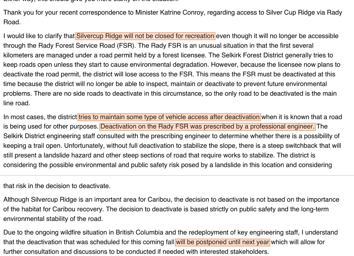
The reason given in 2021 was not safety. It was that the district would lose its own access when the logging permit below it lapsed.
Written at executive-director level, copied to Minister Katrine Conroy. Three things sit in it. The Province states that “the status of the Rady Forest Service Road was unknown at the time the SMA was negotiated” — the clubs signed a caribou stewardship agreement four months earlier without being told. It gives the original rationale: the licensee is giving up the road permit, so “the FSR must be deactivated at this time to prevent future environmental liability.” And it makes two commitments — that the district “tries to maintain some type of vehicle access after deactivation” and that staff will work with the prescribing engineer “to maintain the highest possible level of access for future recreational use.”
Every promise in that correspondence, measured against the prescription
“Tries to maintain some type of vehicle access after deactivation”Four waypoints fully re-contoured
“The highest possible level of access for future recreational use”No ATV access to remain
A meeting with the prescribing engineerAsked for twice. Never held.
The 2017 trail list, the mapping records and the referral letter are all covered by requests published here.
Basically, the Ministry found themselves a cost-cutting catalyst they thought they could sneak through while no one was looking.
A logging company’s road permit had already become the reason there was suddenly no time — two months before that letter was written. It is named in the Ministry’s own consultation paperwork — and that document does more to undo the Ministry’s case than anything the club could have written.
Cooper Creek Cedar — “CCC” in the Ministry’s paperwork — is the forest licensee. It holds two road permit sections, R07745.04 (3.78 km) and R07745.05 (1.657 km), which together form the lower road you drive to reach the start of the Rady FSR. The Ministry says the company was giving those up, and says it had already postponed the work from 2020 to 2021 so the referrals could be run. The company did plan this, and said so in writing in January 2020. The deactivation has still not happened.
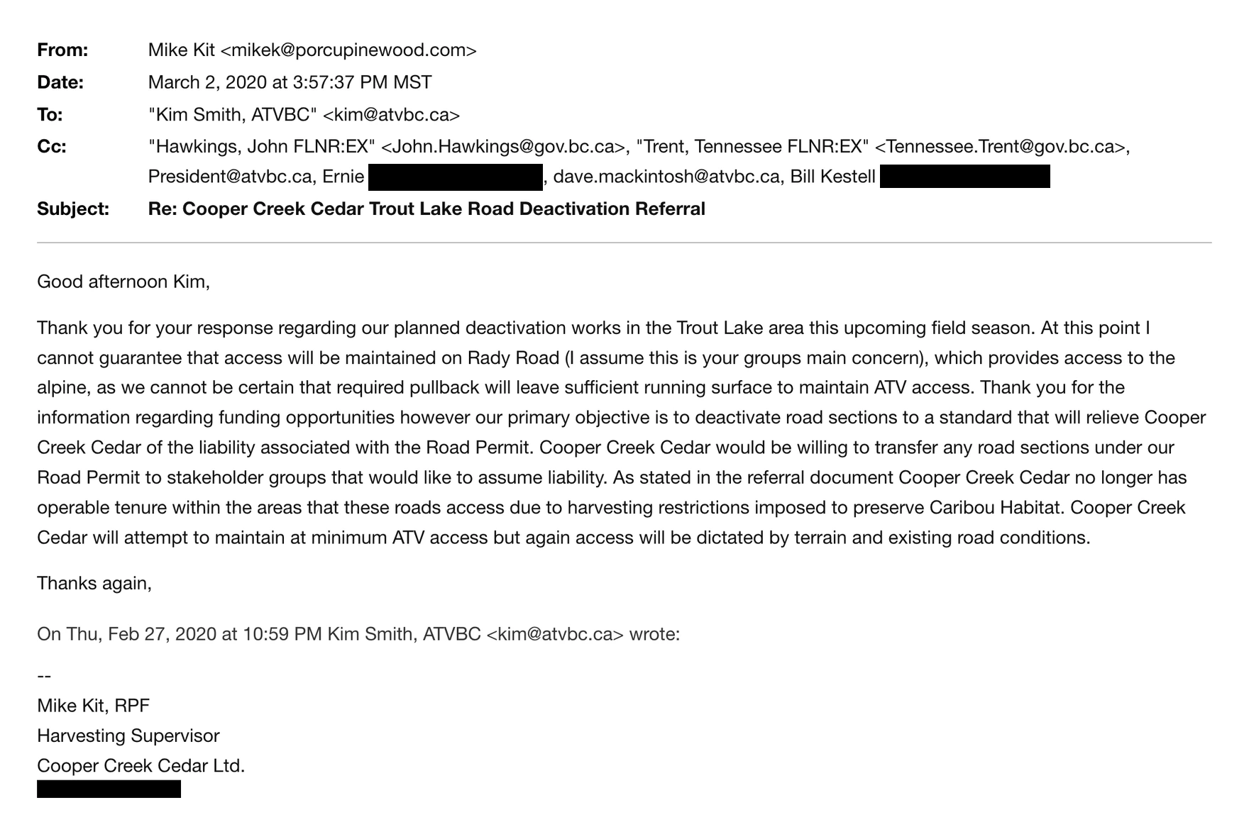
On 14 January 2020, Cooper Creek Cedar ran its own referral. Mike Kit, RPF, the company’s harvesting supervisor, circulated a referral document, maps and a mapping file for “Cooper Creek Cedar’s planned road deactivation works in the Trout Lake Forest Development Unit.” Writing on 2 March 2020, he set out why: the company “no longer has operable tenure within the areas that these roads access due to harvesting restrictions imposed to preserve Caribou Habitat,” and its objective was “to deactivate road sections to a standard that will relieve Cooper Creek Cedar of the liability associated with the Road Permit.”
He also said the company would try to keep the road open to quads.“Cooper Creek Cedar will attempt to maintain at minimum ATV access.” And he offered a way out that nobody took up: “Cooper Creek Cedar would be willing to transfer any road sections under our Road Permit to stakeholder groups that would like to assume liability.” Fourteen months later the Ministry decided there would be no ATV access at all — going further than the licensee had ever proposed. We are approaching Cooper Creek Cedar directly, and we will publish what they tell us — whatever it is.
From that, the Ministry drew its conclusion: once those sections go, “access will be cut off for industrial equipment to get up to the start of the FSR,” and so FLNRORD is “forced to deactivate the FSR prior to CCC deactivating their Road Permit sections.” That is the origin of the deadline — and the First Nations referral went out under it.
Read the whole passage, though, and the argument does not survive its own paragraph.
And four and a half years after the Ministry made that claim, it was still describing that road as live. Its own referral of 17 November 2025 tells a neighbouring licensee it is sending the notice because “the road comes off of a Cooper Creek RP road” — present tense. Whatever was going to cut off access in 2021 had not done so by the end of 2025, and the Ministry now plans to drive excavators up that same road before the snow closes it in 2026.
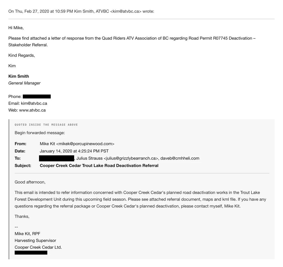
EmailKim Smith, General Manager, Quad Riders ATV Association of BC → Mike Kit, RPF, Cooper Creek Cedar · 27 February 2020 · quoting the referral of 14 January 2020Source ↗
“Cooper Creek Cedar’s planned road deactivation works in the Trout Lake Forest Development Unit.”
The sentence quoted above, in the document it came from. Mike Kit, RPF, opened the referral on 14 January 2020 with three recipients — a heli-ski operator, a guest ranch and one individual, not one of them government — and Kim Smith answered for ATVBC on 27 February, attaching the association’s letter of response. The thread did not end at those three. By Mike Kit’s reply of 2 March it was carrying two Ministry officials as well — the exhibit directly below. That attached letter is the one document in this exchange we still do not hold.
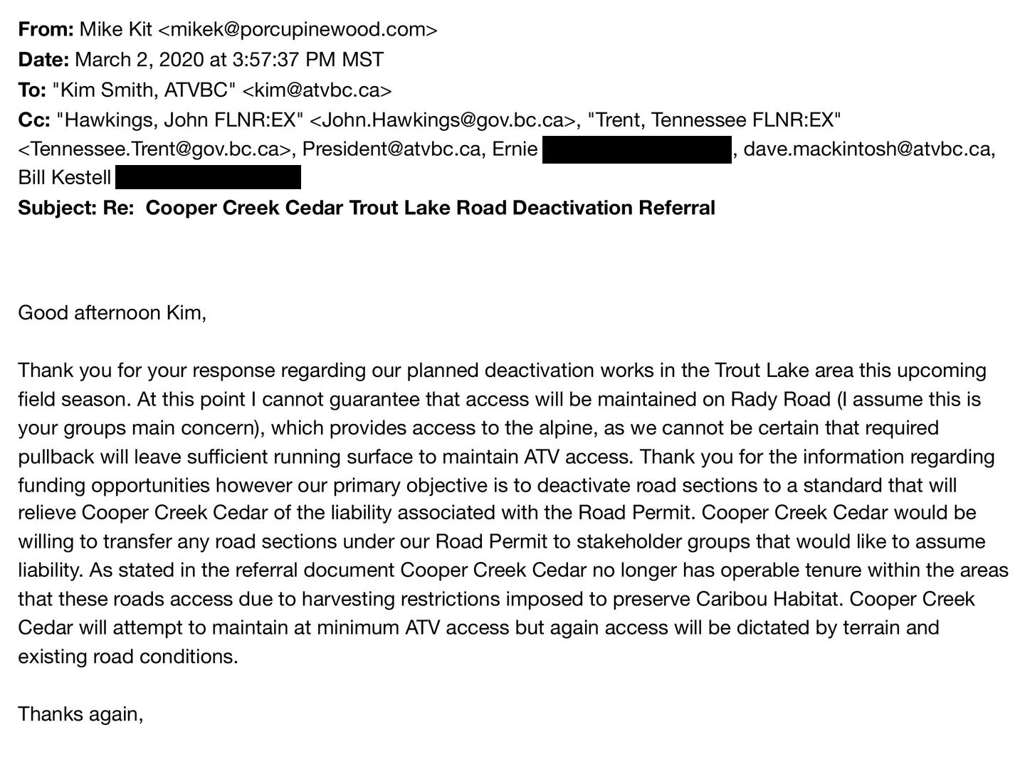
EmailMike Kit, RPF, Cooper Creek Cedar → Kim Smith, General Manager, Quad Riders ATV Association of BC · 2 March 2020 · header block and reply, cc two Ministry officialsSource ↗
Seven weeks on, the same thread is carrying the Province.
The header of the reply, in full. The January referral above went to three recipients and not one of them was government; by 2 March the Cc line holds two Ministry officials — John Hawkings, and Tennessee Trent of Recreation Sites and Trails BC, the one agency that could have designated these routes — alongside two further ATVBC addresses. The reply itself is reproduced whole further down this section.
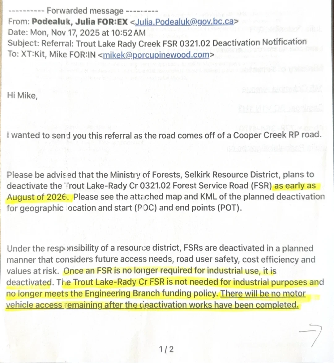
EmailJulia Podealuk, RFT, Ministry of Forests, Selkirk Resource District → Mike Kit, RPF, Cooper Creek Cedar · 17 November 2025Source ↗
“The Trout Lake-Rady Cr FSR is not needed for industrial purposes and no longer meets the Engineering Branch funding policy.”
The sentence quoted above, in the document it came from. The same referral states the Ministry’s reason in its own words, and it is not safety — it is that the road no longer qualifies for maintenance money. It also states the outcome flatly: “There will be no motor vehicle access remaining after the deactivation works have been completed.” The consultation form of 27 April 2021, two exhibits above, had promised the opposite. What the funding policy is, and how a road stops meeting it, is section 02.
The permit is still there
The company planned this work for the 2020 field season and did not carry it out. The Province’s own tenure record still lists both sections as active, with no retirement date. The deadline the Ministry built its case on has not arrived in the five years since.
Read from the tenure registerRoad Permit R07745, Cooper Creek Cedar Ltd. · BC Geographic Warehouse · captured 28 August 2026, 02:40 UTCSource ↗
Section
Name
Length
Life-cycle status
Retirement date
R07745.04
Branch 4
3.7835 km
ACTIVE
none
R07745.05
Branch 5
1.6576 km
ACTIVE
none
R07745.03
Branch 3
0.7372 km
RETIRED
17 June 2011
Sections 04 and 05 are the two the Ministry named — together 5.441 km, the road from Highway 31 to the foot of the Rady FSR. Section 03 on the same permit was retired in 2011, so this shows that there is indeed a field that the Ministry fills in when a road is actually retired.
What this means
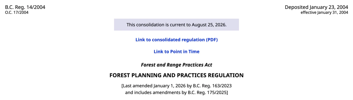
The permit was awarded in 1995 and carries no expiry date. Under section 79 of the Forest Planning and Practices Regulation a road permit runs until the road is deactivated or the permit passes to someone else — it does not lapse on a calendar date. And the licensee is not leaving: Forest Licence A30171 runs to December 2029.
The access below the FSR was never going to disappear on its own. Somebody would have to decide to end it. Five years after the Ministry told First Nations it was “forced to deactivate the FSR,” nobody has.
The unedited response, its HTTP headers, its checksum and an independent Internet Archive capture are filed in the archive. ↗
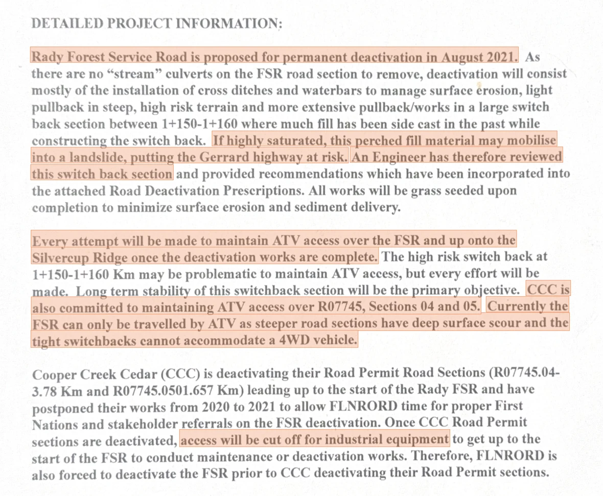
DocumentConsultation Request Intake Form · file 11250-30-0321.02, project 71M2707 · 27 April 2021Source ↗
Three sentences, one page apart, that do not agree with the reason the public was given.
What this means
The deactivation the Ministry built its deadline on has still not happened. The conclusion drawn from it is still standing.
Said
Access will be cut off, so the road has to come out.
Cut off for industrial equipment — the form says so in those words. Two sentences earlier the same form records that “CCC is also committed to maintaining ATV access over R07745, Sections 04 and 05.” The public’s route to the foot of the FSR was never what was ending.Consultation Request Intake Form, 27 Apr 2021
Said
The road must go, for public safety.
The same form states “Currently the FSR can only be travelled by ATV as steeper road sections have deep surface scour and the tight switchbacks cannot accommodate a 4WD vehicle.” By the Ministry’s own description it was already an ATV road, used by ATVs.Consultation Request Intake Form, 27 Apr 2021
Said
Deactivation was always going to end access.
This is the document First Nations and stakeholders were consulted on, and it promised the opposite: “Every attempt will be made to maintain ATV access over the FSR and up onto the Silvercup Ridge once the deactivation works are complete.”NO ACCESS replaced it on 11 May 2021 — fourteen days later.Consultation Request Intake Form, 27 Apr 2021 · amended prescription, 11 May 2021
Said
There is no time; the window is closing.
The form gives the date: “proposed for permanent deactivation in August 2021.” It is now September 2026. Five seasons have passed, the lower road was still driveable enough to plan works, and the FSR is still standing. The deadline never bound, because the event it depended on has still not happened.Consultation Request Intake Form, 27 Apr 2021
Set plainly, the Ministry’s position is that it had to destroy the road now because later it would not be able to drive a machine up to destroy it. The only thing the deadline protected was the ability to carry out the very work it was used to justify — and the referral was answered on that footing.
Five dates carry the whole of it
The road was never the problem. Two parties followed the process properly — the club sought a designation, and the licensee ran its own referral and offered to hand the road over. The Ministry did neither. It reversed its own written commitment in fourteen days, applied to this road none of the notification it was building in July 2022 for four others — Blazed, Jersey, Duhamel Heights and Akokli — and has given five different reasons since. The complete chronology — thirty-five dated entries, each carrying the document behind it — is in section 15.
2017 — the club asks for the one protection available. The Trout Lake Recreational Club maps the routes it rides and maintains and submits the list to Recreation Sites and Trails BC, the one agency that could formally designate them. On 20 March 2017 the club’s secretary-treasurer tells members she has “sent in a list of trails to Travis Mitchell with Recs Sites and Trails” and has telephoned him to arrange a meeting. Eleven days later the district’s recreation officer, Justin Dexter, writes back: “Travis has been keeping me in the loop regarding your interest in snowmobile riding areas in the vicinity of Trout Lake.”Trout Lake Recreational Club to members, 20 March 2017 ↗ · Justin Dexter, Recreation Officer, RSTBC, to the club, 31 March 2017 ↗
31 March 2017 — the agency sends the application form and recommends a different route. In the same reply the recreation officer attaches the Section 57 application form and its guidelines, and sets out four things to weigh before applying. Legally, he writes, “the public can snowmobile on existing resource roads and the area accessed by these roads unless there is a closure in place”; formal establishment “could be considered”, but would mean “a lot of work” — work he would be asking the club itself to do, in helping mitigate the concerns raised from the referral process. His recommendation is a couple of small staging areas instead — “a very effective way of securing use without ruffling feathers and causing a referral nightmare.”Recreation Officer, Kootenay Boundary District, RSTBC, to the club, 31 March 2017 ↗
2017–2026 — the signage goes up, the designation never does.No Section 57 application was made in 2017. Over the two years that follow, that agency installs the Province’s own signage and treats the routes as public, without ever granting the designation that would have protected them. The club applied nine years later, on 20 April 2026, and on 19 August 2026 the agency declined it.The signage, and the account of the 2017 conversation, as the recreation officer gave it nine years later: District Recreation Officer, RSTBC, 19 August 2026 ↗
14 January 2020 — a proposal, not a decision. Mike Kit, RPF, Cooper Creek Cedar’s harvesting supervisor, circulates a referral on proposed deactivation works. It is put out for comment, and nothing in the company’s position removes access — it says it will try to keep the road open to quads. No access is a Ministry position, arrived at sixteen months later.Referral, Trout Lake Forest Development Unit, 14 January 2020 ↗
2 March 2020 — the company offers to hand the road over, and the recreation agency is copied. Cooper Creek Cedar puts two things on the table: “Cooper Creek Cedar will attempt to maintain at minimum ATV access”, and it is “willing to transfer any road sections under our Road Permit to stakeholder groups that would like to assume liability.”Nobody takes either up. On the Cc line is Tennessee Trent, Regional Director of Recreation Sites and Trails BC — the one body that could have designated these routes, holding the company’s own account of the plan fourteen months before the Ministry settled on no access.Reply to ATVBC, 2 March 2020, Cc John Hawkings and Tennessee Trent ↗
27 April 2021 — the referral promises access. The document First Nations and stakeholders were consulted on describes works that keep the road open to quads: “Every attempt will be made to maintain ATV access over the FSR and up onto the Silvercup Ridge once the deactivation works are complete.”Consultation Request Intake Form, 27 April 2021 ↗
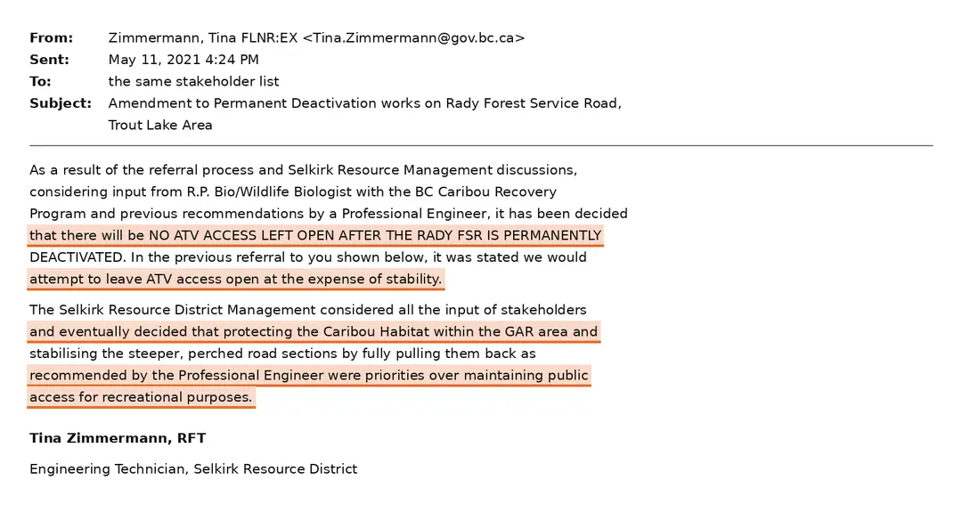
11 May 2021 — fourteen days later, amended to no access. To exactly the people just promised it. The header cell of the prescription is the whole story: the original of 7 October 2020 reads “Access Level Remaining after Deact: ATV”; the revision reads “NO ACCESS”. Every row that had been drawn to leave a quad trail — the five-step graduated pullback, the three water bars, the “Construct ATV’able barricade” — was deleted.“It has been decided that there will be NO ATV ACCESS LEFT OPEN AFTER THE RADY FSR IS PERMANENTLY DEACTIVATED.” ↗
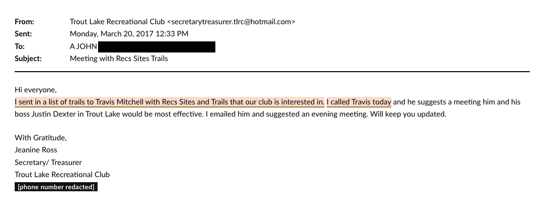
EmailTrout Lake Recreational Club → one named recipient · 20 March 2017 · “Meeting with Recs Sites Trails”Source ↗
The list went in from the club. The meeting was the agency’s suggestion in reply.
Written by the club’s secretary-treasurer nine years before the Section 57 application. It records the trail list going to Travis Mitchell at Recreation Sites and Trails BC and her telephone call to him; the meeting with his supervisor is what Mitchell proposed in return. The body is written to the membership — it opens “Hi everyone” — but the copy we hold went from the club’s role account to one named recipient at a private address, which is what the header above shows.
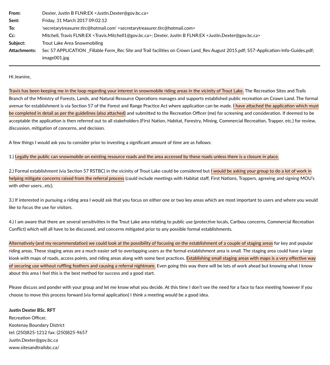
EmailJustin Dexter, Recreation Officer, Kootenay Boundary District, RSTBC → Trout Lake Recreational Club · cc Travis Mitchell · 31 March 2017 · “Trout Lake Area Snowmobiling”Source ↗
The agency attached the application form and set out what applying would involve.
Eleven days after the club’s list went in. The reply attaches the Section 57 application and its guidelines and lists four things to weigh: formal establishment could be considered, “but I would be asking your group to do a lot of work in helping mitigate concerns raised from the referral process”. His recommendation is a couple of small staging areas instead — “a very effective way of securing use without ruffling feathers and causing a referral nightmare.” The header names both attachments. The email closes: “At this time I don’t see the need for a face to face meeting however if you choose to move this process forward (via formal application) I think a meeting would be a good idea.”
Cooper Creek Cedar’s reply to ATVBC, 2 March 2020. It opens by naming what it takes the objection to be — “I assume this is your groups main concern” — then commits to “attempt to maintain at minimum ATV access” and offers to transfer the road sections to any group willing to assume the liability. Tennessee Trent of Recreation Sites and Trails BC is on the Cc line, with a second ministry official, John Hawkings. This is the company’s own referral thread, not a Ministry referral to the agency. ↗ Full thread
What this means
The Ministry did not follow its own process. It ran a First Nations referral on a description of the works, then changed that description fourteen days later and never re-ran it. It built a public notification process — field signs a year ahead, a written comment deadline, a fact sheet at the front desk — and applied it in July 2022 to four other roads — Blazed, Jersey, Duhamel Heights and Akokli — while giving this one none of it. Its own briefing note identifies the section the club should have applied under, and commits to offering the club a way out; the club heard neither for four years. And the two records that would show how the decision was actually made are unavailable: the alternatives the prescriber set out are redacted under FIPPA s.16, and no referral to the recreation agency, or reply from it, appears anywhere in what has been released.
That 2021 letter mentions an engineer's prescription. The club asked for it, and got it. It is not what the Ministry said it was.
04 — The hazard
The landslide nobody can see
The reason the Ministry gives today is public safety, and it has told the public that removal was “prescribed by a professional engineer.” The prescription itself names a Registered Forest Technologist.
It is not a new opinion either. The same document is referenced in the 2021 letter, where the work is described as preventing “future environmental problems.” By 2026 it had become a matter of public safety. The engineering did not change. The framing did.
For five years no terrain stability assessment, no geotechnical report and no hydrology report was published, and the petitioners say none was ever disclosed to them. That changed on 9 September 2026, when the Ministry put the work back out to tender with a forty-two page geotechnical prescription attached — dated the day before, and written five years after the decision it is being used to carry out. What it settles, and what it does not, is set out further down this section.
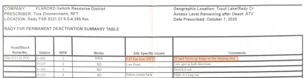
What has been published is the 2025 version of the prescription, dated 7 November 2025 and available to anyone on the Ministry's own website. It lists 79 waypoints across 4,376 metres, each flagged in the field with ribbon and paint. It is not the prescription the club was given. That one was written 7 October 2020, revised 11 May 2021, and lists 91 waypoints over 0.0–4.395 km. We hold all three.
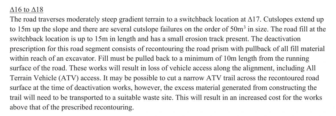
Seventy-five of those waypoints prescribe cross-ditches, fill pull-backs and water bars — work a grader could reverse in a week. Four prescribe full re-contour, which nothing reverses.
The switchback that carries the whole justification is one stretch of it, and the prescription marks exactly where that stretch starts and stops. Its Site Specific Issues column reads, in order, “Start of unstable SB / middle of unstable SB / End unstable SB” — stations 1+150 to 1+192. In ninety-three rows that is the only place the document calls the road unstable.
1+192 − 1+150 = 42 m 42 m ÷ 4,395 m = 0.0096 = 0.96%
The denominator is the prescription’s own header: “LOCATION: Rady FSR 0321.02 0.0-4.395 Km”. The works are scoped to all 4,395 metres; the instability finding is scoped to 42 of them. Roughly thirteen other switchbacks appear in the same table in routine drainage terms — a cross ditch, a swale, “Just upgrade of switch back” — and the word unstable is not used at any of them. That is not a finding that the road is free of hazard, and it is no charge against the prescriber, who wrote down what was found and exactly where. It is the proportion. The instability finding covers 0.96% of the road. The deactivation is prescribed for all 4,395 metres of it.
One switchback.
In 2021, the only section an engineer was recorded as having reviewed, and the only place the landslide risk is stated. The deactivation runs the full 4,395 metres of the prescription. · CRIF 27 Apr 2021 · Zimmermann 28 Apr 2021 · DeCourcy 12 Jul 2021
Read from the prescriptionRady FSR Permanent Deactivation Summary Table · every row containing the word “unstable” · prescribed 7 October 2020, revised 11 May 2021Source ↗
Station
WP#
Works
Site Specific Issues
Comments
1+150
21
XD
Start of unstable SB
Drains to left and into lower XD at 1+160 M, catches H20 coming into SB
1+150
21
Start full pullback/re-contour
unstable switch back
Decompact, then waste pulled material on inside of old road and up cut bank
1+170
—
Pull back pullout to outer edge
middle of unstable SB
Decompact, then waste pulled material on inside and up cut bank
1+192
22
End full pullback/re-contour
End unstable SB
Taper back into XD and existing road
1+192
22
XD
End unstable SB
1+150 Km XD above should drains into this one, by-passing SB
Five rows in the prescription use the word unstable. These are the five, and they run consecutively.
They sit at three stations — 1+150, 1+170 and 1+192 — and the prescriber’s own words fix both ends of the stretch: “Start of unstable SB / middle of unstable SB / End unstable SB”. The length is therefore arithmetic, not inference: 1+192 − 1+150 = 42 m, the run from 1+150 to 1+192. Across the other eighty-eight rows the word never appears again.
The sheet’s own header gives the length being deactivated — 0.0-4.395 Km, or 4,395 m — so the share is 42 ÷ 4,395 = 0.0096, which is 0.96% of the road. Measured instead against the table’s last station, 4+840 — the prescriber’s field chainage for the same road — 42 ÷ 4,840 = 0.87%. The KML released with the prescription traces the centreline across 724 points and measures 4,394.9 metres, within a metre of the header. Whichever denominator you use, the stretch the prescription calls unstable is under one per cent of the road being removed, and the deactivation is prescribed for all of it.
Twenty-two rows mention a switchback, at twenty distinct stations. Five rows, at three stations, are the ones above. Thirteen of the remaining seventeen are drainage and nothing else — twelve cross ditches and one swale, under notes like “Just upgrade of switch back” and “Top of hill into switch back”. The last four rows are the pull-back lines at 2+310, 2+430 and 2+500–2+540. So four switchbacks get fill pulled back under a prescription line of their own — 1+150, 2+310, 2+430 and 2+500. One of the four is called unstable. Thirteen more are described in drainage terms and nothing worse.
The sheet is not silent about the ground elsewhere. Eighteen rows describe steep hill or steep terrain, five ask “Bedrock?”, eight record wet ground, seepage or pooled water, and three name perched fill — 2+610, 2+790 and 4+750 — fill packed onto a sidehill with nothing under it, each given its own pullback. The longest pullback on the road, 140 metres at 1+680–1+820, is prescribed for “Start steep terrain”, not for instability. That is the case the document does make. What it never does at any other station is call the road unstable, and in ninety-three rows it records no washout, no slide, no failure and no geotechnical reference.
Cross ditch — reversiblePull back fill — reversibleWater bar — reversibleFull re-contour — permanent
Drawn the way you travel it — valley on the left, Silvercup Ridge on the right. The prescription itself runs the other way: it is chained from the ridge down, so station 0+000 is the top. Spacing is schematic; treatment types and the four re-contour waypoints are taken from the published prescription map dated 7 November 2025.
The hazard, photographed
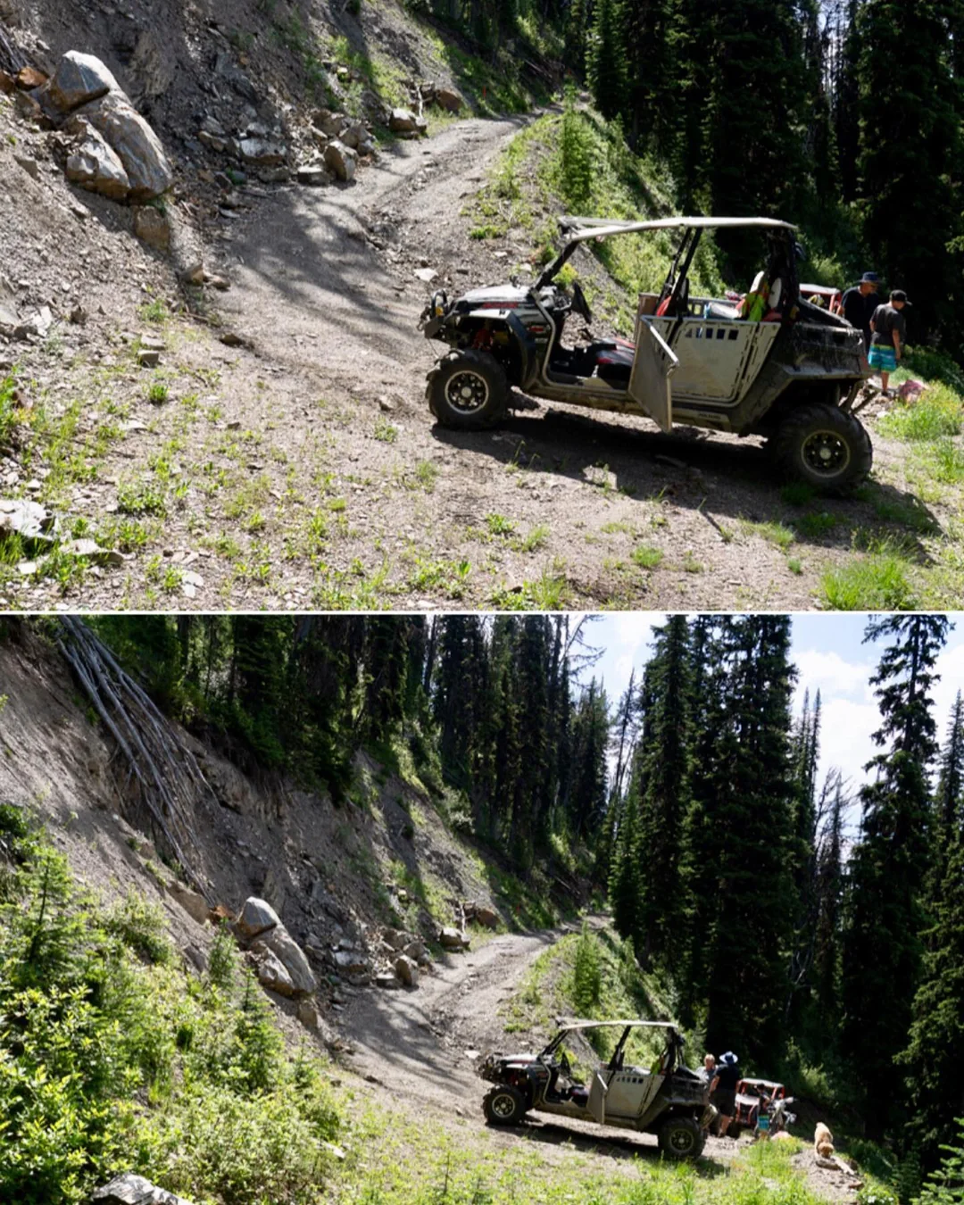
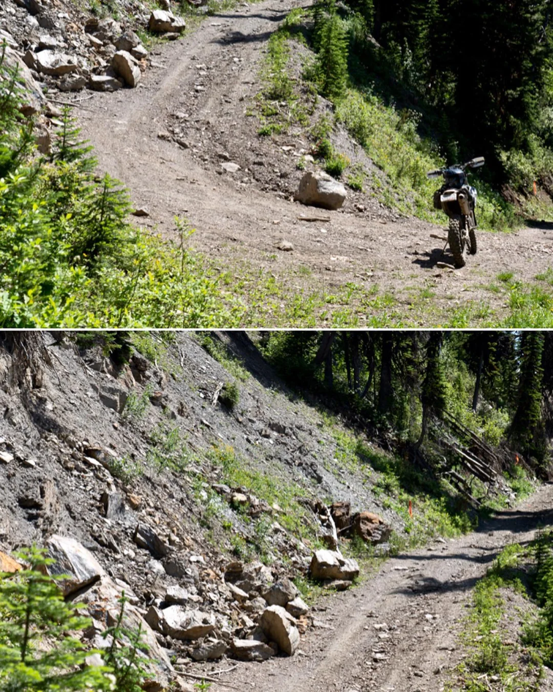
Station 1+150 — the over-steepened switchback that is the stated reason the whole road must come out. Photographed by the club on 18 July 2021, with the Ministry’s survey stakes already planted.
PhotographsThe switchback at 1+150 · 18 July 2021Trout Lake Recreational Club
“The hazardous switchback that will change people’s lives forever. You’ve got to be kidding!”
A side-by-side with two people and a dog; a bike standing unattended. The cutslope above has shed rock — that material is real, and the prescription’s cross ditches are addressed to it. What the photographs do not show is a road that has failed. The club’s caption asks what the file still does not answer: “Why was The Code Red authorized on this road and who authorized it?”
Anyone who has spent time in these mountains will recognise this for what it is: an ordinary mountain switchback. Steep, narrow, loose on the cutbank — the normal condition of a forest service road in the Selkirks, and the condition it has been in for decades.
What each treatment actually does
Cross-sections through the hillside, looking along the road. A forest service road on a sidehill is a bench — material cut out of the uphill face and packed onto the downhill side to make a shelf. Cross-ditching and pull-back damage the surface but leave that shelf in place. Re-contouring drives the cut face down into the bench until the hillside runs unbroken and the shelf no longer exists. Only four of the seventy-nine waypoints call for it — which is why the timing of a pause matters more than the outcome of an argument.
The public notice, five switchbacks up. Alongside a map and a data file on a government webpage, this is the entire public process on record. The date on the sign has passed. August 2026 came and went with the road still standing; the Ministry re-issued the tender on 9 September 2026, closing 24 September. We have left the notice exactly as it is posted rather than redraw it.
Every waypoint was flagged in the field with ribbon and paint. Orange for cross ditch, yellow and black for pull-back, pink for water bar — the Ministry's own legend.
Almost all of this work could be undone — until the excavators reach the four re-contour waypoints. After that there is no bench left to rebuild from.
So who actually wrote the prescription to “fix” this?
The prescription was released to the Trout Lake Recreational Club by the District Manager in
July 2021. It names its author on the first page and again at the signature line.
Prescription · page 1Rady FSR Permanent Deactivation Summary Table · prescribed 7 October 2020, revised 11 May 2021Source ↗
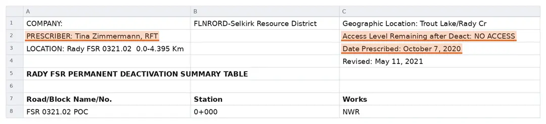
PRESCRIBER: Tina Zimmermann, RFT — a Registered Forest Technologist, not a professional engineer (P.Eng.).
Two other lines on the same page matter as much. “Access Level Remaining after Deact: NO ACCESS” — but that is the header on the revised copy. The original of 7 October 2020 reads “ATV”. The outcome was substituted on 11 May 2021, not arrived at. And “Date Prescribed: October 7, 2020” is the date the original was written — the file’s own embedded properties record it printed 27 April 2021 and modified 11 May 2021, fourteen days apart. The reversal came after the clubs signed the caribou stewardship agreement, and six weeks before the Regional Executive Director wrote that staff would work with the engineer to maintain “the highest possible level of access for future recreational use.”
Prescription · signature lineSame document, foot of the summary tableSource ↗
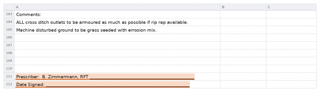
The signature line reads “Prescriber: B. Zimmermann, RFT” — the same person, Bettina Zimmermann, who goes by Tina. The date line beneath it is blank.
The credential appears twice in the Ministry’s own document, and both copies released to the club are unsigned. The last two entries in the summary table are the two lines that would execute it — “Prescriber: B. Zimmermann, RFT ______” and “Date Signed: ______” — and both rules are empty. Neither line is redacted and neither is concealed: we opened the released workbook and read every row, and no row in it is hidden. It is simply an unexecuted document. The file’s embedded properties record its author and last-saved-by as “Zimmermann, Tina FLNR:EX”, and its filename begins TZ. Five years on, the prescription that removes 4,395 metres of public road has not been produced to anyone in signed and dated form. The request for the executed copy, and for the name and registration number of any professional engineer who sealed any part of it, is published here ready to file.
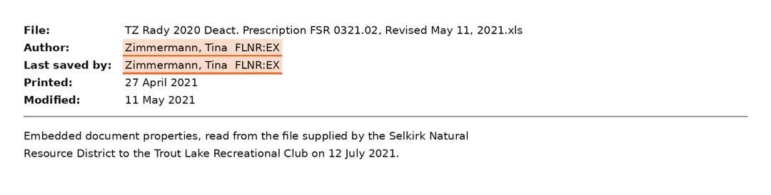
File propertiesEmbedded document properties of the released spreadsheetSource ↗
Author and last saved by: Zimmermann, Tina FLNR:EX.
The file’s own metadata records the same author. It was last printed on 27 April 2021 and last modified on 11 May 2021 — the revision the district was working from while telling the club it would try to preserve access.
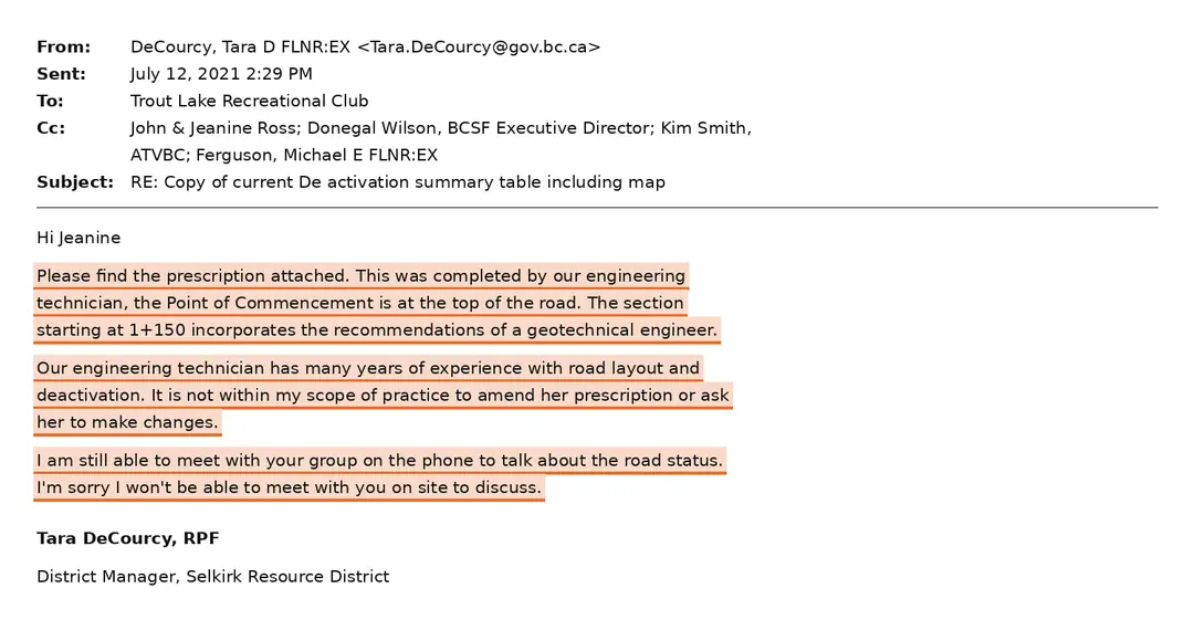
EmailTara DeCourcy, District Manager, Selkirk Natural Resource District → Trout Lake Recreational Club · 12 July 2021Source ↗
“This was completed by our engineering technician… It is not within my scope of practice to amend her prescription.”
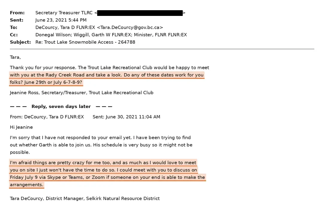
The District Manager — herself an RPF, not an engineer — states plainly who wrote it. An unnamed engineer is credited with recommendations for the switchback at 1+150–1+160. Nobody with that title authored the document, and in November 2021 the District Manager could not say whether any report existed. She also declines a site visit for the second time in three weeks, and Michael E. Ferguson of the Ministry is copied.
A professional assessed this road in August 2026. Nothing we can find informed the decision that was taken five years earlier
This section used to say we could find no evidence that a professional had assessed this road. That is no longer true, and we have rewritten it. A forty-two page geotechnical prescription dated 8 September 2026 went out with the re-tendered bid package the following day. What it is not is evidence about 2021 — which is when the claim below was made, in writing, to the BC Snowmobile Federation with the Minister copied, and when the decision it defends was taken.
The claim, and the file
“Deactivation on the Rady FSR was prescribed by a professional engineer.” — Garth Wiggill, Regional Executive Director, Kootenay Boundary, 22 June 2021. The same sentence is still being given to the public in 2026. The rows below take it in two parts: what the file contains now, and what it contained when the decision was taken.
The 2026 report
Has a professional assessed this road?
Yes — since 8 September 2026. The tender re-issued the following day carries a forty-two page deactivation prescription by SNT Geotechnical Ltd. of Nelson, commissioned by Michael Ferguson, RFT of the Selkirk district and resting on a walking traverse of the road by Ryan Williams, P.Geo. on 18 August 2026. It is a real professional assessment, and this section has been rewritten around it rather than around the sentence it falsified. Two things about it bear on the claim above. It is a geoscientist’s report, not an engineer’s — and it is a different professional, retained five years later, so it settles nothing about who reviewed what in 2021. And nothing in its forty-two pages mentions the 2021 review. The only earlier deactivation document it records having reviewed is the Ministry’s own, described in its background list as “not dated.”Rady FSR Road Deactivation, SNT Geotechnical Ltd., 8 September 2026 · sections 1, 4.1 and 5 · BC Bid opportunity 233877, posted 9 September 2026
The names
So who wrote the 2026 prescription?
On the page, it does not say. The firm’s name occurs thirteen times in the file — once on the cover, once in the contents, twice in the introduction and nine times in the body — and every one of them is covered by a white rectangle painted over the text. So are all three people it names in searchable text: Michael Ferguson, RFT, who commissioned it; Jordan Pyette, RFT, named as the Ministry’s Road Activity Professional of Record and Coordinating Registered Professional; and Ryan Williams, P.Geo., who walked the road. The words are still in the file and copy straight out of it, which is how we read them, and in one place the descender of a letter survives just below its box. We do not know who applied them, or why, and we do not say. What the record shows is that the prescription put in front of bidders does not, on its face, name its author — and nothing else in the package names it either: the invitation to tender and the specimen contract refer only to “the deactivation prescription”, and neither mentions the firm, the geoscientist, or a geotechnical report at all. Both passages are below, exactly as the pages render.Rady FSR Road Deactivation, SNT Geotechnical Ltd., 8 September 2026 · white fills on pages 1, 2, 3, 5, 6, 7, 8, 9, 19 and 20 · confirmed in three independent renderers — poppler, cairo and Ghostscript
Prescription · page 3Rady FSR Road Deactivation · SNT Geotechnical Ltd. · 8 September 2026 · the opening of section 1BC Bid opportunity 233877, posted 9 September 2026
“At the request of [blank] the Ministry of Forests – Selkirk Natural Resource District (MOF), [blank] has completed a permanent road deactivation prescription for the Rady FSR.”
The first sentence of the report, as page 3 renders. The two brackets are ours and mark where the page is blank; every other word is the document’s. Under the first box the file reads “Michael Ferguson, RFT, of”. Under the second it reads “SNT Geotechnical Ltd. (SNTG)”. The report as issued does not say on its face who asked for it, or who wrote it.
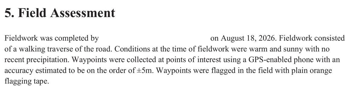
Prescription · page 9Same report · section 5, Field Assessment, in fullBC Bid opportunity 233877, posted 9 September 2026
“Fieldwork was completed by [blank] on August 18, 2026.”
Under that box the file reads “Ryan Williams, P.Geo. of SNTG”. This is the only line in forty-two pages that names the professional who went to the road, and it is the line a reader most needs. On the page it is empty.
The rest of the section is shown whole so nothing is taken out of context: a walking traverse, warm and sunny, waypoints by GPS-enabled phone to about ±5 m, flagged with plain orange tape. That is the field method the prescription rests on, in the report’s own words.
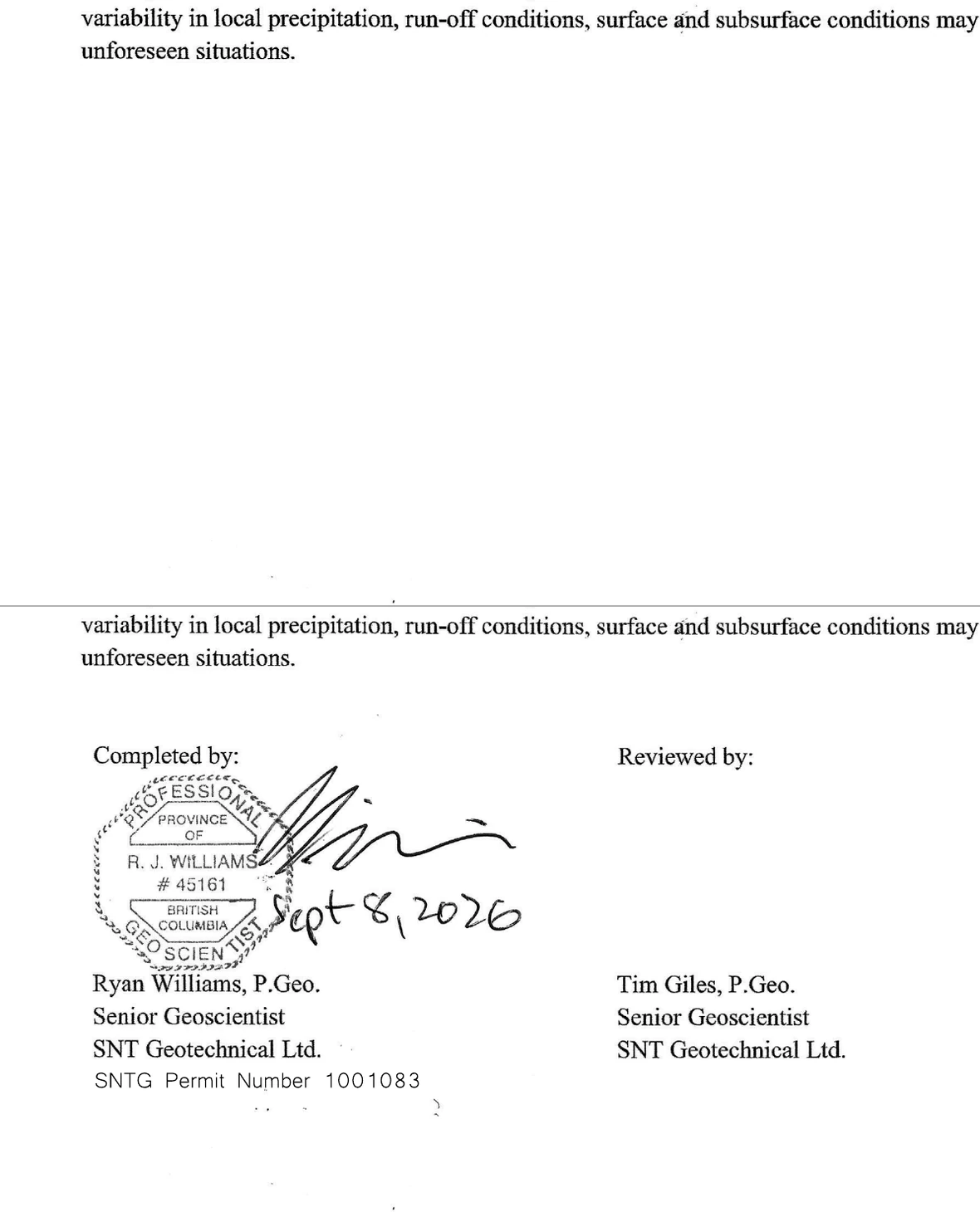
Prescription · page 20Same report · section 8, Closure — above, as the tender issues it; below, with the two white fills removedBC Bid opportunity 233877, posted 9 September 2026
The prescription is sealed. The page it is sealed on is distributed with the seal painted out.
Page 20 is the only one of the forty-two that is a scan rather than digital text — which is what a wet-signed page becomes. Its content stream draws that scan and then paints two rectangles over it, in the page’s own separation colour at zero tint, which is paper rather than ink: one of 57 × 38 points over the firm’s letterhead, and one of 395 × 192 points over the whole signature block. On the page as issued there is nothing under the closing paragraph but white space.
The lower panel is the same file with those two rectangles deleted from that one content stream and nothing else altered — no reconstruction, and no enhancement beyond a contrast stretch applied identically to both panels. It takes a few lines to reproduce from the published PDF, which is the point. Under the box: a Professional Geoscientist’s seal, R. J. Williams, #45161, signed and hand-dated Sept 8, 2026; below it Ryan Williams, P.Geo., Senior Geoscientist, SNT Geotechnical Ltd., SNTG Permit Number 1001083; and in the second column Tim Giles, P.Geo., who reviewed it. Neither name appears in the report’s searchable text, because this page has none.
The file records when it was made and nothing about why. It was produced from Microsoft Word by Acrobat Distiller on 9 September 2026 at 11:26 — the day after the date on the seal, and the day the re-tendered package was posted. The rectangles are part of the page content that conversion produced: the file carries no annotation layer, no second producer and no later edit. We do not know who applied them, or why, and we do not say.
The engineer
What did the engineer actually do?
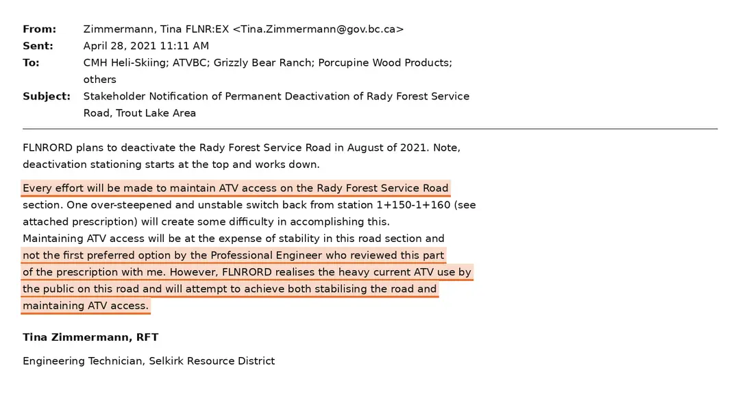
Reviewed one switchback, and said so three times in three documents. “An Engineer has therefore reviewed this switch back section.”“The Professional Engineer who reviewed this part of the prescription with me.”“The section starting at 1+150 incorporates the recommendations of a geotechnical engineer.” Not the road. Not the prescription. One switchback.CRIF, 27 Apr 2021 · Zimmermann to stakeholders, 28 Apr 2021 · DeCourcy, 12 July 2021
The report
Where is the engineering that justifies removing the prescription’s 4,395 metres?
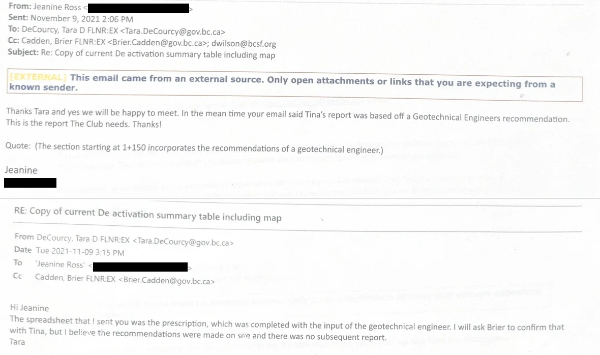
The club asked for it directly, quoting the Ministry’s own line back. The District Manager answered twice in one afternoon, and both times said she believed no report had been written. She undertook to confirm with the prescriber. No confirmation appears anywhere in the released record. Her reply is below, in full.Ross to DeCourcy and replies, 9 November 2021
EmailTara DeCourcy, RPF, District Manager → Jeanine Ross, Trout Lake Recreational Club · 9 November 2021Source ↗
“I will ask Brier to confirm that with Tina, but I believe the recommendations were made on site and there was no subsequent report.”
Shown in the order it happened. At 2:06 pm the club asks for the engineer’s report by name — “This is the report The Club needs.” At 3:15 pm, sixty-nine minutes later, that is the answer. Four months after transmitting the prescription, asked directly for the engineering behind it, the District Manager does not produce it, does not name the engineer, and is not certain it exists.
The seal
Is there an engineer’s seal on any of it?
Not an engineer’s — and finding that out meant looking under a white box. The 2025 prescription map carries a professional seal, a Registered Forest Technologist’s. The copy released to the club in 2021 is unsigned altogether, its prescriber and date lines both blank. The September 2026 prescription is sealed and signed. Its page 20 carries the seal of a Professional Geoscientist of the Province of British Columbia, R. J. Williams, #45161, over a signature hand-dated Sept 8, 2026 — the date on the report — above the typed lines Ryan Williams, P.Geo., Senior Geoscientist, SNT Geotechnical Ltd., and beside a second column reading Reviewed by: Tim Giles, P.Geo. That is the rule the report’s own introduction sets out for itself, met: a Qualified Registered Professional “must prepare, sign, and seal a prescription for road deactivation works” — a rule that names four qualifications, RFT, RPF, P. Eng. or P. Geo. What the tender distributes is that page with the seal painted over. The exhibit is below, beside the same page with the fill removed. We do not know who applied it, or why, and we do not say.Deactivation Prescription Map, 7 Nov 2025 · prescription released 12 July 2021 · Rady FSR Road Deactivation, SNT Geotechnical Ltd., 8 September 2026, page 20 and page 3 section 1
The credential
Engineer — or geoscientist?
Two weeks after the Regional Executive Director sent that sentence to the BC Snowmobile Federation, the District Manager set out the same assessment for him in writing, and named a different profession.“The district engineering technician created a deactivation prescription with the recommendations of a professional geoscientist for one particularly unstable section.” — Briefing Note for Information, Tara DeCourcy, District Manager, to Garth Wiggill, Regional Executive Director, 6 July 2021 ↗Six days later she told the club the same stretch carried “the recommendations of a geotechnical engineer”. On 26 October the Ministry’s stock reply returned to “prescribed by a professional engineer.” Under the Engineers and Geoscientists Regulation, B.C. Reg. 14/2021, in force since 5 February 2021, those are not two words for one thing: professional engineer and professional geoscientist are separate titles, each reserved by law for its own class of registrant, with separate scopes. Geoscience covers “the investigation of surface or subsurface geological conditions”; engineering covers advice “based on an engineering discipline.” One person can hold both. This one has never been named, and no report of that review has ever been produced, so the file cannot settle which it was.What this does — and does not — show. The separation is real. Schedule 1, s. 5 of the Professional Governance Act, SBC 2018, c. 47 defines professional engineer and professional geoscientist as separate registration categories with separate regulated practices, and the titles themselves are reserved — s. 51(1)(a) of that Act, and ss. 4 and 8 of the Engineers and Geoscientists Regulation, which puts engineering in Part 2 and geoscience in Part 3. They are not two words for one qualification. But no rule required an engineer here, and we do not say one was broken. The deactivation provision the Ministry itself listed on the intake form for this project — s. 82 of the Forest Planning and Practices Regulation — imposes its duties on “a person” and names no profession at all. The word qualified does not appear anywhere in that regulation, or in the Forest and Range Practices Act. The one BC regulation that ever did require a professional to prepare a deactivation prescription — the Forest Road Regulation, B.C. Reg. 351/2002, s. 15(2) — was repealed on 31 January 2004, and even it called for a qualified registered professional, defined by education, experience and membership of whichever regulatory body governs the activity. Not an engineer.So the discrepancy is not illegality. It is that the Ministry described its own reviewer three different ways in its own records — a professional engineer, a geotechnical engineer, and a professional geoscientist — gave the public the first, and has never named the person or produced the report that would settle which it was.Wiggill 22 Jun 2021 · Briefing note 6 Jul 2021 · DeCourcy 12 Jul 2021 · Ministry stock reply 26 Oct 2021 · Engineers and Geoscientists Regulation ss. 2, 4, 6, 8 ↗ · Professional Governance Act, Schedule 1 s. 5 and s. 51(1)(a) ↗ · Forest Planning and Practices Regulation s. 82 ↗ · Forest Road Regulation B.C. Reg. 351/2002, repealed by B.C. Reg. 7/2004 ↗ · Sections listed by the Ministry on the intake form, 27 Apr 2021 ↗
What is actually established
Two questions, and the answers are not the same. A professional geoscientist walked this road on 18 August 2026, and a forty-two page prescription followed three weeks later. We do not dispute it and we do not diminish it. It is evidence about the ground in August 2026 — not about a decision taken in 2021, and it does not claim to be.
On the 2021 claim, nothing has changed. Take the Ministry’s account at its highest and it still does not reach it. Its own documents say an engineer reviewed one switchback — “this part of the prescription.” A Regional Executive Director turned that into the professional prescription of a 4,395-metre road. The first statement cannot support the second, on any reading.
And the first statement has never been substantiated. No report of that review has ever been produced. That engineer has never been named. Nothing from 2021 is signed or sealed. Asked directly, the District Manager twice said she believed none was ever written — “I don’t think a specific report was completed”, “I believe the recommendations were made on site” — and undertook to confirm that with the prescriber. No confirmation is in the released record. Five years on, nothing further has come.
If anything, the new document sharpens the point. This road was walked by a professional on 18 August 2026 and the report is dated 8 September — the day before the work went back out to tender. The only earlier deactivation document that assessment records having reviewed is the Ministry’s own, which it describes as “not dated”, and no earlier engineering report on this road appears on that list. That list is what one consultant reviewed, not a register of what exists, so it does not prove nothing was written in 2021. It is simply that after five years of asking, the earliest professional assessment of this road anyone can point to is three weeks old. And it was not asked whether the road should come out — the report records, in its own bold and before its deactivation plan begins, that “the road is intended to be deactivated to a permanent standard.”
And we also now know they were saying one thing in the document, while saying something else to the public…
The prescription is dated. So is everything the Ministry told the community. Put the two
side by side and the sequence is not ambiguous.
On the prescriptionWhat the community was told
7 October 2020“Access Level Remaining after Deact: ATV.” The first prescription keeps ATV access and engineers for it — “build up ATV trail”, and at the final waypoint, “construct ATV’able barricade”.
24 March 2021 · five months later
The clubs sign a caribou stewardship agreement with the Province. Nobody mentions the road.
11 May 2021
The prescription is revised. The header now reads NO ACCESS, every ATV-trail instruction is deleted, and the signature line is still blank.
22 June 2021 · six weeks later
The Regional Executive Director writes that staff will work with the engineer “to maintain the highest possible level of access for future recreational use.”
12 July 2021
The District Manager sends the club the document itself. NO ACCESS is on the first page of it.
Same email
She writes that it was “completed by our engineering technician” — and declines, for the second time in three weeks, to walk the road.
Through hindsight we now also know: the same document, five years apart
The prescription released to the club in 2021 and the one published on the Ministry’s
website in 2025 are the same instrument. The waypoint count changed. The author’s credential,
the design intent and the unstable switchback did not.
Version released to the club
Version published in 2025
Dated
Prescribed 7 October 2020 revised 11 May 2021
7 November 2025
Length
0.0 – 4.395 km
4,376 m
Waypoints
91
79
Prescriber
Bettina Zimmermann, RFT
No engineer named publicly
Access remaining
NO ACCESS
No ATV access after completion
First re-contour
1+150 — “unstable switch back”
The switchback is still the stated hazard
Cross ditches
74 of 91
75 of 79
Signed
No. Date line blank
Sealed — by a Registered Forest Technologist
Twelve waypoints came off the list, one more cross ditch went on it, and the 2025 copy carries a seal the 2021 copy does not. The reason for the work never moved. The same
switchback at 1+150 that justified full re-contour in October 2020 is the switchback the Ministry
still points to in 2026 — assessed by the same Registered Forest Technologist, on a document
revised once, from ATV access to none, and carrying no engineer’s signature on either copy.
But what is even worse is that before all this, there was a version that kept the road — and the Ministry designed it.
Before any of the reversal, the same prescriber had already worked out how to stabilise this ground and leave people a way through. It was the plan of record for seven months.
The original header. There is no Revised line on this version.
PrescriptionStation 1+150 – 1+160 · the unstable switchbackSource ↗
“Pull as much fill as possible while still leaving an elevated ATV trail on inside.”
At the same switchback now given as the reason the whole road must come out, the instruction was to take the fill back and keep a trail. The line appears twice, on consecutive rows. Two rows up: “Decompact & waste material on inside ditch-use to build up ATV trail.”
PrescriptionStation 4+840 · the point of terminationSource ↗
“Construct ATV’able barricade.”
At the bottom of the work, a barricade an ATV could pass. In the May 2021 revision that became a ninety-metre re-contour, and the note reads that the re-contour “will act as a barricade.”
Why this matters more than anything else on this page
Stabilising this switchback and keeping access were never alternatives. The Ministry’s own technical staff designed a version that did both, and it stood as the plan for seven months.
Nor can the licensee explain the change. Whatever the Ministry believed about Cooper Creek Cedar’s intentions, both permit sections are still active today — and the October 2020 prescription, written before the Ministry ever put those intentions on paper, still specified ATV.
So the reversal was not forced by the ground, and not forced by the licensee. Something changed between October and May, and the record does not say what — or who decided it.
Thirteen days from “every effort will be made” to “NO ATV ACCESS”
Between these two emails nothing changed on the ground. The same officer wrote to those same five — the heli-ski operator, ATVBC, a lodge, a mill and a resident — then to those five and a sixth, and reversed the undertaking entirely.
EmailTina Zimmermann, RFT, Engineering Technician, Selkirk Resource District → stakeholders · 28 April 2021Source ↗
“Every effort will be made to maintain ATV access on the Rady Forest Service Road section.”
She is specific about the difficulty and specific about the intent: the switchback at 1+150–1+160 will make it hard, keeping access will cost stability, and it is “not the first preferred option by the Professional Engineer.” Even so — “FLNRORD realises the heavy current ATV use by the public on this road and will attempt to achieve both stabilising the road and maintaining ATV access.”
Read the engineer’s role carefully. He is “the Professional Engineer who reviewed this part of the prescription with me” — a document, reviewed with the person who wrote it. Nothing on the record says he attended the site, and he is never named.
EmailThe same officer, one more recipient · 11 May 2021Source ↗
“It has been decided that there will be NO ATV ACCESS LEFT OPEN AFTER THE RADY FSR IS PERMANENTLY DEACTIVATED.”
Her own email acknowledges the reversal: “In the previous referral to you shown below, it was stated we would attempt to leave ATV access open at the expense of stability.” This is the day the prescription file was last saved.
And here is the reason the Ministry gave its own stakeholders in May 2021. District management decided that “protecting the Caribou Habitat within the GAR area” and stabilising the perched sections “were priorities over maintaining public access for recreational purposes.” Caribou is named first, and the input came from a wildlife biologist with the BC Caribou Recovery Program. This is the reason as it stood that month, not the reason as it stands now — by October the Ministry was telling the public the decision was not based on caribou at all, and four more reasons have followed since.
And here is exactly who “you” was. The 28 April notification went to five addresses; this reversal went to those five and a sixth: daveb@cmhheli.com, the heli-ski operator; kim@atvbc.ca, the ATV association; julius@grizzlybearranch.ca, a lodge; dan@porcupinewood.com, a wood-products contractor; and two residents, [resident’s private address] and [resident’s private address]. Not one is a government address. Recreation Sites and Trails BC — the office holding the club’s trail maps, and the only body that could have designated these routes — is not on the list. Neither is the Trout Lake Recreational Club. The heli-ski operator that had told the Ministry its runs were being affected by “unregulated snowmobile use from Trout Lake” is on both lists. The organisation those snowmobilers ride with is on neither. ↗
What this means
Set the engineering aside for a moment. The prescription changed, and the file records the order it changed in.
Said
The outcome was always no access.
The first prescription, 7 October 2020, reads “Access Level Remaining after Deact: ATV” and prescribes works to “build up ATV trail” and “construct ATV’able barricade”. NO ACCESS replaced it on 11 May 2021.Both versions of the prescription, pages 1–8
Said
Engineering drove the change.
The prescriber’s own transmittal calls it “my amended prescription once no ATV access was decided” — the decision first, the engineering after. The record never says who decided.Zimmermann to Ferguson, 21 June 2021 · FOI release p.378
05 — The silence
Every promise, broken in writing
In 2021 the Ministry of Forests made four commitments about this road. Each one was made in writing. Each one was made to people who had asked politely and in good faith. Not one of them was kept.
The reasons changed too. The road had to go because a logging licensee was walking away. Then it was not about caribou — strictly about public safety. Then the caribou came back. Then there was no money. Then the public had already been consulted.
Five years, five reasons, four broken promises, and one road that is still scheduled to come out before the snow.
What the Ministry put in writingWhat actually happened
22 Jun 2021 · Regional Executive Director
“In most cases, the district tries to maintain some type of vehicle access after deactivation when it is known that a road is being used for other purposes.”
Nov 2025 · the prescription
Four waypoints prescribe full re-contour. The bench is removed and nothing drives it again.
22 Jun 2021 · Regional Executive Director
Staff “will continue to work with the prescribing engineer to maintain the highest possible level of access for future recreational use.”
11 May 2021 · six weeks earlier
The position had already flipped to no ATV access remaining. The commitment above was given six weeks after the decision to remove it.
22 Jun 2021 · BC Snowmobile Federation asks
To meet the prescribing engineer and review the plan, with the goal of deactivating and keeping access.
Five years on
The meeting never happened. The prescriber’s name reached the club only on the document itself, a year later.
23 Jun 2021 · Jeanine Ross, Trout Lake Recreational Club
To walk the road together at Rady Creek — 29 June, or 6, 7, 8 or 9 July.
30 Jun 2021 · seven days later
“I just won’t have the time to do so.” A video call is offered instead.
26 Oct 2021 · sent to everyone who wrote in
Postponed “which will allow for further consultation and discussions to be conducted if needed with interested stakeholders.”
25 Aug 2026No consultation has taken place. The road is still scheduled to come out — with the undertaking given, and not kept, for the third time.
“Only be travelled by ATV” is not true either
The same 2021 form the Ministry used to consult First Nations also told them what kind of road this is. That description is wrong, and the government’s own recreation officer contradicted it five years later.
What the road actually carries
The claim: “Currently the FSR can only be travelled by ATV as steeper road sections have deep surface scour and the tight switchbacks cannot accommodate a 4WD vehicle.” — Consultation Request Intake Form, 27 April 2021.
The government’s own officer, 2026
Recreation Sites and Trails BC, declining the club’s trail application.
The District Recreation Officer describes this road as having “the mining interest (industrial use), business interest, and highway vehicle interest of this road.”Highway vehicles are licensed road vehicles — trucks and 4x4s, not ATVs. A road that cannot accommodate a 4WD vehicle does not have a highway vehicle interest.Justin Dexter, District Recreation Officer, RSTBC · Section 57 decision, 19 August 2026
The prescription’s own field note
What is at the top of the road, according to the surveyor?
At station 0+000, the Point of Commencement, the prescriber recorded: “Ht land Silvercup Ridge on flat camping area.” A camping area at the height of land, written into the Ministry’s own summary table — at the far end of a road it described in the same period as passable only by quad.Rady FSR Permanent Deactivation Summary Table, station 0+000
The people who drive it
Who actually travels this road, and in what?
Full-size pickups, 4x4s and overlanders run this road through the summer, and people camp in the bowl at the top. The club’s own submission to the Ministry describes “light duty vehicles accessing this popular amazing place.” This is the account of the people who use it and maintain it, and it is consistent with both government records above.Trout Lake Recreational Club to the Ministry, 20 November 2025
DecisionJustin Dexter, District Recreation Officer, RSTBC · Section 57 application declined · 19 August 2026Source ↗
The government’s own recreation officer, five years later: this road has a highway vehicle interest.
The orange highlight is ours. The yellow one is in the Ministry’s document. Everything else is as released.
Read from the mineral titles registerMineral titles register · BC Geographic Warehouse · WFS 2.0.0 · EPSG:3005 · retrieved 30 August 2026MTA_ACQUIRED_TENURE_SVW ↗
Tenure
Registered
Area
Road it crosses
Registered owner
1081046
8 Feb 2021 · claim
513.2 ha
R07745
Red Pony Exploration Ltd
1081048
8 Feb 2021 · claim
513.4 ha
R07745
Red Pony Exploration Ltd
1089231
20 Jan 2022 · claim
61.6 ha
R07745
Red Pony Exploration Ltd
1106383
29 Jul 2023 · claim
41.0 ha
Rady FSR and R07745
Adamowicz, Robert John
1126383
26 Sep 2025 · application
82.1 ha
R07745
Funk, Kelly Brent
1132739
1 May 2026 · claim
20.5 ha
R07745
Scott, Steven Jeffrey
19 AUGUST 2026 — THE SECTION 57 DECISION
1137735
27 Aug 2026 · application
1,409.1 ha
R07745
Gustafsson, Cody Daniel
1137802
28 Aug 2026 · claim
123.1 ha
Rady FSR
Bakus, John Nick
1138129
28 Aug 2026 · claim
184.6 ha
Rady FSR
Bakus, John Nick
The decision names a mining interest. It does not name whose. Mineral title is a public register, so we read it.
Nine mineral tenures cross this corridor. Six were on the register before 19 August 2026, and five of those six sit on road permit R07745 — the lower road, below the FSR — not on the Rady FSR at all. Exactly one is on the Rady FSR itself: tenure 1106383, 41.0 ha, registered 29 July 2023 to Robert John Adamowicz. The register’s own name for it is “RADY CREEK MCX - TROUT LK”. On this road, that is the only holder the phrase can reasonably mean.
Three more tenures were registered after the decision: 1137735 on 27 August, eight days after, and 1137802 and 1138129 on 28 August, nine days after. The last two lie directly on the Rady FSR. We publish that as a fact of the register and nothing further. We have no evidence of any connection between the decision and the staking, and we do not suggest one.
Two limits, and they matter. This layer is a live snapshot, not a point-in-time record: it shows the register as it stood on 30 August 2026, so a tenure that lapsed between 19 and 30 August would not appear here at all. And ownership as at the decision date cannot be rebuilt from the public service either — the history layer, MTA_ACQUIRED_TENURE_HISTORY_SP, carries geometry revisions only, with no owner field and no date field. What stood on the register on 19 August is not something this record can settle.Tenure numbers, registration dates, areas and registered owner names are fields of the public mineral titles register; nothing beyond those fields is published here. Crown-granted mineral claims are a separate layer — fifty fall inside the same search box, and none of their polygons crosses either road. MTA_CROWN_GRANT_MIN_CLAIM_SVW ↗
PrescriptionRady FSR Permanent Deactivation Summary Table · station 0+000, the Point of CommencementSource ↗
“Ht land Silvercup Ridge on flat camping area.”
The surveyor’s own note at the top of the road, beside “9.83 Km from HWY.” This crop is the 7 October 2020 sheet — header ATV — but the row is unchanged in the 11 May 2021 NO ACCESS revision.
LetterTrout Lake Recreational Club to the Ministry · 20 November 2025Source ↗
“…our summer months of recreational activities and light duty vehicles accessing this popular amazing place.”
The club’s own description, written to the Ministry. The wording is theirs.
DocumentConsultation Request Intake Form · submitted 27 April 2021Source ↗
Kootenay Boundary Region – First Nations Relations. Submitted 27 April 2021. Response required 9 August 2021.
This is the header of the form carrying the description above. The copy released to us is page one; it ends at “MAPPING & GEOSPATIAL DATA”.
And the form is where the shape of that decision should be recorded. It prints both routes — single-agency and multi-agency — and marks neither.
Same formProvincial approach, authorisation and termSource ↗
The form prints both routes on one line — Single-Agency Decision or Multi Agency-Coordinated Project Decision — and marks neither.
That is the difference between other agencies deciding with you and other agencies being sent a notice, and the form does not record which of them happened here. What it does record is a single decision maker: under AUTHORIZATION TYPE it reads District Manager responsible / Forest Service Road. Recreation Sites and Trails BC — the agency holding the club’s trail maps, and the only one that could have designated this road — appears nowhere on the page. No referral to it, and no reply from it, appears in anything released to us, and it is on neither of the stakeholder notifications the district did send — five recipients on 28 April 2021, six on 11 May (section 04). We hold page one only; if a route was recorded, it was recorded on a page we have not been given. Nothing on the form is marked, and we have added no emphasis of our own. The term on the form runs 27 April 2021 to 31 March 2026; the work was scheduled for August 2026 and was re-tendered on 9 September 2026.
2021:“can only be travelled by ATV.”2026:“highway vehicle interest.” Every summer this road carries full-size pickups and 4x4s to the alpine, and the people who drive and maintain this road in them are missing from every description the Ministry wrote. Why?
The same project, described four different ways
Between April and October 2021 the Ministry described this deactivation to four different audiences. The descriptions do not agree with each other. All four are in writing.
Who was told what
The premise was that engineering required this. Each audience got a version shaped to what it was likely to accept.
27 April 2021 · to First Nations
The referral document — the basis on which consultation was run.
“Every attempt will be made to maintain ATV access over the FSR and up onto the Silvercup Ridge once the deactivation works are complete.” The same form records that the licensee “is also committed to maintaining ATV access over R07745, Sections 04 and 05.”Consultation Request Intake Form, file 11250-30-0321.02, project 71M2707
28 April 2021 · to industry and clubs
Sent to CMH, ATVBC, Grizzly Bear Ranch and Porcupine Wood Products.
“Every effort will be made to maintain ATV access.” One day after the referral went out, the same undertaking is given to the commercial operators and the clubs.Zimmermann, RFT, Selkirk Resource District, to stakeholders, 28 April 2021 ↗
28 April 2021 · to mine claims and water users
The same notification signs off by promising a second one.
“Mine claims and water users will be addressed in a separate e-mail.” That is the closing line of the 28 April stakeholder notification, immediately above the prescriber’s signature block. No such e-mail appears in anything released to us — not in the records held by the Trout Lake Recreational Club, and not in the referral material for project 71M2707 that has been released to us. We are not saying it was never sent. We are saying it is not in the record, and the record is what the Ministry has produced. It matters because the 2026 refusal of the club’s application cited “the mining interest” as a reason without naming a single tenure holder — and this is the one document the Ministry itself said would identify that audience. It has been requested by that phrase and that date.Zimmermann, RFT, Selkirk Resource District, to stakeholders, 28 April 2021 — final line ↗
11 May 2021 · to that same list
Thirteen days later, to exactly the people who had just been promised access.
“NO ATV ACCESS LEFT OPEN AFTER THE RADY FSR IS PERMANENTLY DEACTIVATED.” The reason given here is not safety: protecting “the Caribou Habitat within the GAR area” and stabilising the road “were priorities over maintaining public access for recreational purposes.”Zimmermann to stakeholders · prescription header amended the same day
26 October 2021 · to the public
Sent to everyone who had written in to object.
The public is told the decision was not based on caribou habitat — the reason given to industry five months earlier. By 2026 the reason offered publicly has changed again, to removal “prescribed by a professional engineer.” The prescription names a Registered Forest Technologist, and no engineering report exists.Ministry response to correspondents · public statements, 2026
Why this is not just inconsistency
Consultation was run on the 27 April description. NO ACCESS replaced it fourteen days later. The referral was answered on a description of the project that no longer existed — and there is no record in anything released to us of that referral being run again.
The engineering did not drive this. The prescriber said so in her own transmittal: the document she sent was “my amended prescription once no ATV access was decided.” The access outcome came first. The prescription was amended to match it. The record still does not say who decided.
Nevertheless, the club and the federation asked to meet the engineer. Twice. It never happened.
Correspondence from 2021, held by the Trout Lake Recreational Club and provided to us in
full. In June the club and the BC Snowmobile Federation asked to meet the engineer and walk the road.
In October the Ministry postponed the work and put the reason in writing.
EmailDonegal Wilson, Executive Director, BC Snowmobile Federation → Garth Wiggill · 22 June 2021Source ↗
“Would it be possible for the BCSF and the Trout Lake Recreational Club to meet with the prescribing engineer, yourself, and Tara to review the deactivation plan…?”
The same day the letter arrived, BCSF asked to sit down with the engineer who wrote the prescription and review the plan — with the explicit goal of deactivating in a way that addressed the environmental concern while keeping snowmobile access. That meeting never happened. The prescriber’s name reached the club only when the document itself was released a year later.
EmailTara DeCourcy, District Manager → Donegal Wilson, BC Snowmobile Federation · 23 June 2021, 3:25 pmSource ↗
“I am able to meet with the club, if a representative could get in touch with me I will try to find a time that Garth and I are available.”
The meeting was the Ministry’s own offer. The club replied two hours and nineteen minutes later with five dates.
EmailTrout Lake Recreational Club → Tara DeCourcy, District Manager, Selkirk Natural Resource District · 23 and 30 June 2021Source ↗
The club offered five dates to walk the road. The District Manager replied a week later, proposing a video call.
Jeanine Ross, Secretary-Treasurer of the Trout Lake Recreational Club, put five dates on the table — June 29, or July 6, 7, 8 or 9 — to meet at Rady Creek and look at the road together. The reply came seven days later: “as much as I would love to meet you on site I just won’t have the time to do so.” Skype, Teams or Zoom were offered in its place, if the club would arrange the call.
LetterConstituency office of Hon. Katrine Conroy, Minister of Forests → Jeanine Ross, Secretary-Treasurer, Trout Lake Recreational Club · 26 October 2021Source ↗
“…which will allow for further consultation and discussions to be conducted if needed with interested stakeholders.”
The Ministry postponed the work in the autumn of 2021 and said in writing why: to allow for consultation. The covering note makes clear this was not a private assurance — “a bit of what has been sent to most people who have written”. The same promise went to everyone who wrote in.
Five years later, no consultation for Rady Creek appears anywhere on the record. The same letter also states that the decision “is not based on the importance of the habitat for Caribou recovery” and rests “strictly on public safety” — a reason the Ministry has cited repeatedly since.
At this point it will be hard to believe, but the Ministry does know how to do consultation properly
Thirty kilometres from Rady Creek, the same district office deactivated another Forest Service Road — the Incomappleux, FSR 3397. Same decision-maker, same years. That one got a published FAQ, mailed notice three years running, a newspaper advertisement, a formal comment period and draft prescriptions released for review. Rady Creek got a map and a data file, sent to a lumber company.Frequently Asked Questions — Incomappleux Forest Service Road Deactivation · Ministry of Forests · April 2025 · file 11250-30/3397 ↗
What this means
The Ministry cannot argue it did not know what proper consultation looks like. It ran one thirty kilometres away and documented every step. It cannot argue nobody asked, because two organisations asked in writing and a third offered five dates. And it cannot argue the promise was never made, because it made that promise to everyone who wrote in. What it can do is run out the clock — and that is what it has done for five years.
What the office did with the letters
People grew frustrated and started sending letters. A Change.org petition had published the district office’s own email addresses, and members of the public were writing to the Minister and to their MLA directly. So what did the Ministry do with those letters? It decided, in forty-nine minutes.
EmailSelkirk Resource District staff · 13 July 2021 · released at pages 428–429 of 1410Source ↗
“Anything addressed to the minister will come to us through CLIFF and be answered by the RED, so you can just throw those ones away.”
The chain reads newest first, so it runs backwards. Four exchanges, forty-nine minutes.
2:55 pm — a member of the public’s letter arrives and is passed along: “And another one. At least these people are from BC.” That letter had asked about search-and-rescue access, wildfire response, people who cannot climb from the valley bottom, and the Alice Jowett memorial.
3:23 pm — “I think we will treat this as a letter writing campaign now and just create a stock response.”
3:27 pm — the officer is holding the letters, unanswered.
3:36 pm — “Anything addressed to the minister will come to us through CLIFF and be answered by the RED, so you can just throw those ones away.”
CLIFF is the ministry’s correspondence tracking system; RED is the Regional Executive Director.
And here is the stock response
Three months later it went out, the same letter to everyone who had written in.
LetterMinistry response relayed by MLA Katrine Conroy’s office · 26 October 2021Source ↗
The same letter went to everyone who had written in.
What this letter was for
Read it against the email chain above and it is not a reply at all. It is the product of a decision taken at 3:23 that July afternoon: treat the public as a letter writing campaign, and issue a stock response.
It deflects rather than answers. The letters had asked about search and rescue, wildfire access, and people who cannot climb from the valley bottom. None of it is addressed. What the letter offers instead is delay — the work “will be postponed until next year” — which costs the Ministry nothing and concedes nothing.
Two of its assurances are also false on the Ministry’s own file. “In most cases, the district tries to maintain some type of vehicle access” — by the date of this letter the prescription had read NO ACCESS for five months. “Prescribed by a professional engineer” — it names a Registered Forest Technologist, and no engineering report exists.Ministry response relayed by MLA Katrine Conroy’s office, 26 October 2021
Then the Province sold the public five more years
If running out the clock is the Ministry’s strategy, then the permit is the clock. Four years into the deactivation plan, the Province took the club’s $250 permit fee — plus the $25 habitat conservation trust fund surcharge — and issued it a fresh five-year authorisation to ride the very area this road serves. Nineteen months later the excavators were booked. Both documents are the Province’s. Only one of them can be honoured.
PermitWildlife Act permit CB24-908956, amended · Ministry of Water, Land and Resource Stewardship · issued 9 January 2025Source ↗
“This permit is only valid from January 9, 2025 to December 31, 2029.”
The permit exempts club members from the Motor Vehicle Prohibition Regulation across the Central Selkirk Snowmobile Management Area. It succeeds CB19-598335, which ran from January 2020. Both rest on a Stewardship Management Agreement the Province co-signed. The Province negotiated it, issued the permits under it, and is now removing the ground access the permitted activity depends on. The authorisation runs more than three years past the month the road is due to come out.
The two amounts are printed on the face of the permit — PERMIT FEE $250.00 and HCTF SURCHARGE $25.00 — and they are set by regulation, not negotiated. Schedule 3 of the Wildlife Act Permit Regulation, B.C. Reg. 253/2000, sets a $50 fee and a $5 habitat conservation trust fund surcharge for a permit under section 3 (2), the exemption section this permit is issued under. Section 22 (3) makes those “the annual fee and habitat conservation trust fund surcharge that are to be charged for each full year or portion of a year for which the permit is issued.” Five years, so $250 and $25. The amounts are unchanged in the consolidation current to 25 August 2026. ↗
EmailJustin Dexter, District Recreation Officer, Recreation Sites and Trails BC → Trout Lake Recreational Club · 19 August 2026, 8:30 amSource ↗
“I did approve the installation of trail names and directional signage for public safety reasons.”
The permit is not the only thing the Province granted. Recounting it in August 2026, the recreation officer says his office told the club that “authorization was not needed to utilize these roads for public use” — and then went further, approving trail names and directional signage on them. The Province put its own wayfinding on this corridor and told the public it was theirs to use. Signage, a stewardship agreement, and two Wildlife Act permits: four separate acts of recognition, each one made by the same government now removing the road they point along.
Club members say it plainly in the LetsGetLost documentary: they handed the province their full trail list in 2017 — the list that produced these signs — and watched the areas on that list narrow and close ever since, in step with what the heli-ski operators were asking for. That is their testimony, on the record, in a published film. Whether the two were connected is not something we can show from the documents, and we do not claim it. What the operators asked for in writing is set out in section 07.
So it seems pretty clear the Ministry had little to no interest in listening to these BC locals. There is, however, a record that shows exactly who they were listening to at this time. It is actually a matter of public registry — they track who they listen to: Lobbyists.
06 — The decision room
Who has been in the room
British Columbia keeps a public lobbyist registry. Every registered contact between a lobbyist and a senior public official is filed, dated, numbered and searchable by anyone. It takes ten minutes to learn to use, and anyone can see who the government is spending its time listening to on matters of public interest.
Directly behind Silvercup Ridge sits Galena Lodge, operated by Canadian Mountain Holidays. Its own management plan states the size outright — “The tenure covers 1167.44 sq km”, which is 116,744 hectares — and its title page names the tenure that figure belongs to: MFLNRO file 4401094, the Licence of Occupation #340826 CMH was applying to replace for a further 45 years. The Province’s own mapping agrees with its licensee. In the TANTALIS crown-tenures layer of the BC Geographic Warehouse, captured 30 August 2026, the polygon filed under 4401094 — document 340826, commercial recreation / heli ski, Trout Lake, disposition in good standing — measures 116,704 hectares. That is 0.03% from the number in the plan: the operator’s claim and the government’s map are the same tenure. Galena is one of six CMH areas in the tenure-replacement file the Province released — Gothics, Adamants, Galena, Monashees, Revelstoke and Bobbie Burns — and the areas those six plans state for themselves add to 7,349 square kilometres, about 735,000 hectares. All of it is commercial recreation tenure issued by the Ministry of Forests. ↗ The industry association for heli-skiing and cat-skiing is HeliCat Canada, and it retains two registered consultant lobbyists: Greg D’Avignon and Berit Beattie. D’Avignon’s registration — number 1251-6130, opened 14 July 2025 and still active — answers “Yes” to whether he will be arranging meetings between a public office holder and the client. ↗ The twelve-month summary records that the consultant “has lobbied, or plans to lobby a member of the Legislative Assembly, including a Minister or Premier.”↗
Those 162 filings are not history. Between December 2025 and July 2026, HeliCat's registered contacts include near-monthly meetings with the Director and a policy specialist of the provincial Wildlife Branch — the officials who run the caribou file that has been used to close this terrain. It reached two deputy ministers repeatedly across May, June and July of this year. It reached the Deputy Minister to the Premier. It reached the Minister of Environment and Parks directly.
In the same period, the people who use Rady Creek wrote letters. Steve Shannon's 2020–21 petition, which he says drew over nine thousand signatures and he believes passed ten thousand, went to the Minister of Forests and got nothing back. The petition the club is running now is a separate one, and its total is not a recollection: the archived capture of the Change.org page records 7,639 verified signatures as at 26 August 2026. ↗ When seventy people gathered at Trout Lake in July and invited the Ministry, it sent natural resource officers — who told the crowd they were not permitted past the barricade.
Total registered lobbying activity reports, BC Office of the Registrar of Lobbying, retrieved 24 August 2026. Every entry is public and citable by activity number.Derived from the fifty most recent filings retrieved from the registry.
What this means
Access to public land in this province is being decided in rooms that recreational users have never been in. One industry association has more registered meetings with this government in thirteen months than every motorised recreation group in British Columbia has had in a decade. That is not a coincidence of scale. It is what a closed process produces.
The registry records that those meetings happened. It does not record what was said in them. For that, there are the documents.
07 — The lobbyists
What these lobbyists said
The lobbying registry shows that the meetings happened. It does not show what was said in them. What was said is partly on the public record already — three freedom-of-information packages the Province released in 2023 and 2024, published on its own disclosure site. We did not request them. We went and read them.
Three freedom-of-information packages came back — 108 pages, covering the same years. They are heli-ski tenure files: six Licences of Occupation under review, caribou conditions, GPS flight data, tenure term. Every page is published below, and every exhibit links to the original release on the Province's own open information portal.
Read together they show what the registry cannot. Through the years either side of this decision, the commercial operator flying Silvercup Ridge was telling the Ministry of Forests in writing — to the officials deciding its licences — that public recreation on that ridge was a problem for its business.
The heli-ski operators gave up nothing and got the Minister. The club gave up riding area and got enforcement officers.
When the Province wanted data from the companies flying this terrain, it invited their chief executives to meet the Minister and asked for it voluntarily. They declined, for years, and kept operating. When seventy people gathered at Trout Lake and asked to meet the decision-makers, the Ministry sent enforcement officers, who told them they could not pass the barricade.
EXHIBIT 01
WLR-2024-41783 · Meeting note for Hon. Nathan Cullen · 16 May 2024
Mining and forestry must observe timing windows and setback distances, and must supply detailed spatial data on their operations. Four bullets later in the same note, data from heli-tourism operators is to be provided on a voluntary basis. Recreational users are not asked for anything, because they are simply closed out of the terrain.
The Province records that it has sought flight path data for several years and that HeliCat has not provided it — while some individual operators have. The association’s stated objections: the data might become public, the industry is being unfairly targeted, and there is no clear plan for its use. The same page notes limited evidence that operators comply with the recommended two-kilometre setback from caribou.
EXHIBIT 03
FOR-2023-31284 · Briefing Note for Decision · 1 Feb 2021
Forestry and mining took steps to support caribou recovery. The briefing note states plainly that the lack of similar improvements from the adventure tourism sector diminishes the credibility of the Province’s own recovery efforts. Prepared for Deputy Minister John Allan, three days before the Trout Lake clubs signed their stewardship agreement.
EXHIBIT 04
FOR-2023-31284 · same note · authored by Michelle Porter and Darcy Peel
The Ministry writes that HeliCat Canada has historically resisted requests to voluntarily supply GPS flight data and may resume lobbying efforts to block these changes. This is the government anticipating, in a decision document, that an industry association will lobby against a caribou measure.
The ridge, named, in the operator's own words
CMH Galena Heli-ski Management Plan, 15 July 2020 — filed with the Ministry in support of a request to replace Licence of Occupation #340826 for a further 45-year term. The tenure covers 1,167 square kilometres. Silvercup Ridge is one of its thirteen ski zones.
EXHIBIT 05
FOR-2023-31283 · CMH Galena Management Plan · zone description · 15 July 2020
In the description of its Silver Cup zone, the operator records that the runs are “becoming increasingly affected by (and less useable as a result of) unregulated snowmobile use from Trout Lake.” The town is named. The ridge is named. The document is dated eight months before the Trout Lake clubs learned the road was going.
EXHIBIT 06
FOR-2023-31283 · same plan · section 7.1, Public Use and Access
Under a heading that opens by stating the operation “do not restrict public access in any way,” the plan goes on to record rising snowmobile use “particularly in the vicinity of Silver Cup Ridge” and concludes: “There are some areas that we can no longer ski due to the snowmobile traffic.”
EXHIBIT 07
FOR-2023-31283 · Dave Butler, CMH, to Tracy Ronmark, Director of Authorizations · Nov 2022
Writing to the official deciding six of its tenure replacements, CMH lists its grievances: tenure term, wildlife issues, old growth deferrals, and “lack of management of public recreation.” Elsewhere in the same correspondence, “growing unmanaged public recreation” is described as “creating both safety and experiential issues for us.” The sector, he writes, faces “a death by a thousand cuts.”
EXHIBIT 08
FOR-2023-31283 · Ministry of Forests to CMH · 17 Feb 2022
The conditions the Ministry proposed attaching to the renewed licences: record every caribou sighting, track all GPS flight data including flight paths and landing locations, report twice yearly, and do not operate within 2,000 metres horizontally or 500 metres vertically of caribou. For Galena, a referral recommendation asks that a temporarily closed area in critical caribou winter range become permanently closed, amendable only if the herd is extirpated.
The ridge is inside that tenure. The road is not.
The plan above names Silver Cup Ridge, and names the town whose snowmobilers it says are the problem. This is where that terrain sits on the Province’s own mapping. Silvercup Ridge is inside the Galena tenure. The Rady FSR is outside it, and stops 723 metres short of the boundary. The road is the ground route into tenured terrain — it is not tenured ground, and nothing in the tenure record gives CMH any interest in the road itself.
The tenure boundary stops 723 metres short of the road. Silvercup Ridge sits 464 metres inside it — and 1,687 metres from the top of the road.
The tenure measured here is the one the plan above was filed for. The Province’s tenure layer records it as Crown lands file 4401094, tenure document 340826, purpose commercial recreation / heli ski, location Trout Lake, status disposition in good standing. Those are the same two numbers the released plan carries — “MFLNRO File Number: 4401094”, and a request to replace “the existing License of Occupation (#340826)”. The polygon measures 116,704 ha against the 116,744 ha the plan states for itself: 0.03 per cent apart.
The road’s own tenure record is a different record and says nothing about heli-skiing. FTEN_ROAD_SECTION_LINES_SVW lists section 0321.02 as ACTIVE, named “TROUT LAKE-RADY CR”, mapped length 4.396 km, held by the Selkirk Forest District.
The closures run the other way. Every one of the 724 mapped points on the Rady FSR falls inside the Central Selkirk Snowmobile Management Area — 97,501 ha, carried in that layer as a legal closure — and inside ungulate winter range u-4-014, 253,165 ha. Of the 4,291 points on road permit R07745, 2,771 fall inside the snowmobile closure and 2,682 inside the winter range. Silvercup Ridge is inside both. The closure covers the road. The tenure does not.Central Selkirk closure · AMA_SNOWMOBILE_MGMT_AREAS_SP · retrieved 30 August 2026 ↗ · winter range · WCP_UNGULATE_WINTER_RANGE_SP · same date ↗
And here is what this record cannot show. The word Rady does not appear anywhere in the 85 pages of FOR-2023-31283 — not once. The Galena plan never states its own boundary either: it places the operating area “north, east and south of Trout Lake” and otherwise says only “see approved Management Plan map”. That map is not in the release. In this record the boundary exists only as the polygon in the Province’s tenure layer — which is the polygon measured above.Distances computed in EPSG:3005, BC Albers metres, from the archived responses. Each query, its HTTP headers and its SHA-256 checksum are filed with the archive.
The list of people the Ministry told about this road
Everything above is CMH writing to the Ministry about its tenures. This is the Ministry writing to CMH about Rady Creek itself — the two 2021 emails that promised ATV access and then withdrew it, sent to the same private list — five recipients, then six.
DocumentCMH Galena Management Plan · Silver Cup zone description · 15 July 2020 · FOR-2023-31283Gov release ↗Source ↗
The party that complained was on the list. The party complained about was not.
Above: the complaint itself, nine months before the notification — CMH’s own management plan, reproduced in full as Exhibit 05 below.
The 28 April notification went to five: CMH, ATVBC, Grizzly Bear Ranch, Porcupine Wood Products and one resident. The 11 May reversal went to those five plus a second resident. Both notification emails are reproduced in full in section 04.↗ Every one outside government — and the Trout Lake Recreational Club is not among them. The club is not hard to reach: the letter it sent the District Manager in November 2025 came from its own address, the same one it has used with the Ministry throughout. ATVBC, a provincial association, was the only recreation organisation on the list. The club whose members ride this road was not written to at all.
Nine months before that notification went out, CMH had told the Ministry in its own management plan that the Silver Cup runs were “becoming increasingly affected by (and less useable as a result of) unregulated snowmobile use from Trout Lake”, and that there were “areas that we can no longer ski due to the snowmobile traffic.” It then received both halves of what the district decided about the road those snowmobilers use: on 28 April 2021, “Every effort will be made to maintain ATV access”; on 11 May 2021, “NO ATV ACCESS LEFT OPEN AFTER THE RADY FSR IS PERMANENTLY DEACTIVATED”.
Same ridge, two users, and only one of them in the room. The clubs signed the caribou stewardship agreement in February 2021 and gave up riding area; the operation flying the same terrain faced no equivalent restriction, and was on the notification list for the road the clubs use. Nothing released to us shows CMH asking for this road to be deactivated — but it did not need to ask to be told, and the people it was complaining about were not.
The emails
Released with headers intact — sender, recipient, timestamp, subject line. These are the exchanges between the operator and the officials deciding its tenures.
Email 01Dave Butler, CMH → Tracy Ronmark, Director of Authorizations, Ministry of Forests · 15 March 2023Gov release ↗Source ↗
Dave Butler, Director of Sustainability, CMH — to the official adjudicating six of the company’s tenure replacements.
The header establishes the relationship the rest of this section rests on. CMH’s Director of Sustainability is corresponding directly with the Ministry of Forests Director of Authorizations for the Kootenay-Boundary region — the region containing Trout Lake and Rady Creek — about six Licences of Occupation awaiting decision.
Email 02Butler → Ronmark · 28 November 2022 · forwarded in the same threadGov release ↗Source ↗
“I’d like to bring some additional information to your attention as part of your review of these key mid-term replacement applications.”
The long submission. Butler responds point by point, in italics, to the Ministry’s position on tenure term, caribou conditions and flight data. It is a lobbying document in the ordinary sense of the word — an operator putting its case to a decision-maker while a decision is pending.
“Growing unmanaged public recreation … is creating both safety and experiential issues for us.”
Butler sets out what he calls a contradiction: being asked to do more on stewardship — flight data, greater separation distance from wildlife — at greater cost, while being offered shorter tenures. In the same breath he lists the pressures the company is under, and public recreation is one of them.
“On almost every front — tenure term, wildlife issues, lack of management of public recreation … we are facing a death by a thousand cuts.”
The closing appeal. “Lack of management of public recreation” sits in a list of grievances put to the person deciding the tenures, alongside a request that she weigh all of it — “not just what you receive from your government colleagues.”
Email 05Lauren Knowlan, Authorizations Specialist, Ministry of Forests → Dave Butler · 17 February 2022Gov release ↗Source ↗
The Ministry sets out what it wants in return: every caribou sighting logged, all GPS flight paths tracked, and a 2,000-metre exclusion around caribou.
The conditions the Ministry proposed writing into the renewed licences — and, for the Galena file specifically, a referral recommendation that a temporary caribou closure become permanent, amendable only in the event of extirpation. This is the ask that HeliCat had resisted for years, arriving as a tenure condition.
Email 06Jennifer Psyllakis, WLRS → Vera Vukelich, Lynn Brunsdon, Michelle Porter, Ministry of Forests · 17 March 2023Gov release ↗Source ↗
Subject: “Another mtng between WLRS DM Lori Halls and Adventure Tourism Coalition re policy change response.”
The government side of the same room. Senior officials across two ministries coordinating a briefing note for the Deputy Minister ahead of another meeting with the industry coalition — one of many. No equivalent thread exists for the recreation groups using this terrain, because no equivalent meetings took place.
What the file shows
Through the same years the registry records those meetings, the operator flying Silvercup Ridge was putting a documented commercial case to the Ministry of Forests: public recreation on that ridge was reducing what it could sell, and the sector wanted it managed. That case went to named officials, in writing, while decisions on its licences were pending. The people who use the road were in none of those rooms.
One record would settle what the Ministry actually weighed — any referral of FSR 0321.02 to Recreation Sites and Trails BC, and any reply. Neither has been released to us: the district’s own stakeholder notifications for this road went to five addresses on 28 April 2021 and six on 11 May, and not one of them is a government address. We do not say no referral was made. A stakeholder submission shown in the documentary quotes the Ministry as stating that referrals were sent to that agency and that no comments came back from it — we hold the film, not that letter, and the difference is set out in the questions. The letter itself is the subject of one of the requests published here. Somebody else went looking too.
08 — The documentary
What the locals told the camera
In August 2026 Tyler at LetsGetLost spent two days on this road and in Trout Lake, checking the government's stated reasons against what residents, prospectors and club members told him — and against records obtained under freedom of information.
Government Doesn't Want us Here… We Tried to Find Out Why — Tyler, LetsGetLost, August 2026. Published independently. 31 minutes.
Watch on YouTube ↗ ·
Subscribe to the channel ↗
The film draws what is left
One frame carries the whole claim: the riding area the club had, and the piece of it still open.
“We’re down to 95% of our riding area is gone.”
Trout Lake Recreational Club · in the film at 8:30
The film’s own graphic, on screen while that number is said. The colour key is the club’s, given earlier in the same interview: “the green shows everywhere that we used to snowmobile, and the orange shows where we can snowmobile now” — so the green is the former extent and the orange is what remains. It is an extent map only: it carries no trail names and no legend, and nothing on it can be read at the level of an individual route. Documentary at 4:47, 7:44 and 8:30. ↗
The locals sat down with Tyler
Just over fifty people live in Trout Lake full-time. This is what they told him.
“Just got the cold shoulder. No response, nothing.”
Steve Shannon · Original petition organiser · Kootenay SAR volunteer
He is careful about the number on camera: “I’d have to check the exact numbers, but it was over 9,000. I think it ended up being well over 10,000 signatures on it.” That was the 2020–21 petition, not the one the club is running now. He sent it to the Minister of Forests and heard back nothing at all.
“We’ve been cut by 90% of our snowmobiling area.”
Jeanine · Trout Lake Recreational Club
She holds up the before and after of the club’s riding area. If Rady Creek goes, she says, it is 95%.
“That’s not the deal we made.”
Jeanine · Trout Lake Recreational Club
The club handed Recreation Sites and Trails BC its full trail list in 2017. One by one, every trail on that list was deactivated except two.
“That’s like killing the patient to cure the cold.”
Warren Mirko · Founder, Public Land Use Society
The Ministry’s offer: it removes the road and re-contours the slope first, and claim holders may then apply for a permit to rebuild it.
“A convenient lie.”
Thomas Gardner · Taranis Resources · wilderness first responder
Asked whether closing the road protects the public. Gardner is a wilderness first responder and a volunteer with local search and rescue.
“Another stroke of the pen, displacing the people who made their lives here.”
Thomas Gardner · Taranis Resources
His family left Scotland in the Highland Clearances. Ferguson, the ghost town below this ridge, is named for the Scot who founded it.
“They decided it wasn’t a high recreation value place. We just weren’t important.”
Jeanine · Trout Lake Recreational Club
On being left out of the room while commercial operators behind the same ridge sat in monthly meetings with deputy ministers.
“They say they did, but they did not.”
Darryl Davis · Davis Mining and Exploration Corp
On the Ministry’s account that it contacted the claim, Crown grant and private property holders above the road.
“You can’t say you’re protecting the environment while leaving toxic mine sites to leach into the streams.”
Steve Shannon · Original petition organiser · Kootenay SAR volunteer
Historic workings across this area were never remediated. Removing the road removes the only way to get equipment in to do it.
The film ends without a definitive answer, because the documents that would give one have not been released. But put everything above it together, and the shape of this is not ambiguous.
09 — The verdict
What the evidence shows
The Province withheld maintenance funding from this class of road for more than a decade and kept no records of what that did. The designation that would have restored the funding never came, and nothing released to us shows it was ever considered — after the community had done everything the agency asked of it. When the club finally applied in 2026 the answer was not a refusal on the merits but a jurisdictional one: the guideline excludes Forest Service Roads, and the officer pointed at a different instrument in a different ministry. It told the clubs in 2021 that the road had to go because a logging licensee was giving up the permit below it — then produced an unpublished safety opinion to justify removal, on a road it had never inspected to a standard it could produce. It promised consultation in writing to everyone who wrote in, then skipped the consultation process it had just run, in full, thirty kilometres away. And through all of it, the commercial operator behind the same ridge sat in monthly meetings with the deputy ministers and wildlife officials making these calls, while the people who use this road could not get a reply to a petition its organiser puts at over nine thousand signatures. That same operator had already told the Ministry, in writing, that snowmobiles from Trout Lake were making Silvercup Ridge less useable.
The Auditor General was clear that none of this was required. In its own words: “there is no trigger or timeline for deactivation and FSRs can remain open indefinitely if they are maintained as wilderness roads” — Management of Forest Service Roads, p. 11. A forest service road can stay exactly where it is, indefinitely, if someone pays to maintain it. Removal is not an obligation. It is a decision — and it can be unmade this week by one instruction from the Minister's office.
This road is not being removed because it is dangerous. It is being removed because it was allowed to become inconvenient.
Rady Creek is one road. But the mechanism that condemned it — no transition pathway, no designation, no consultation, no record — is now becoming standard operating procedure for public access across British Columbia, as more and more roads go unmaintained to the standard the government’s own engineers asked for.
Decisions to close roads are being made behind closed doors, to satisfy the financial interests of the Ministry and private-sector lobbyists, without ever doing the technical engineering or the public consultation. Auditors have been calling this out at the Ministry of Forests since 2008. Nothing seemingly has changed.
In this district alone, four more roads are already in the queue. There is no process anywhere in the province for turning a retired industrial road into a managed recreation route. The only tool the Ministry has is the excavator.
The pattern will not stop at Trout Lake unless it is stopped at Trout Lake.
10 — A real solution
There is no way to turn a road into a trail
This is the gap underpinning everything that needs fixing about public access to the backcountry, and the reason we are bringing this to the public with a solution in hand.
When a Forest Service Road stops being needed for logging, British Columbia has exactly one tool for it: deactivation. There is no mechanism to hand that same corridor to Recreation Sites and Trails BC and keep it open as a managed recreation route.
Not a slow mechanism. Not an underfunded one. None. The Ministry of Forests cannot transfer a road footprint into the recreation system, because no pathway to do it has ever been built.
So when the industrial use ends, the only question a district can answer is how much of the road to destroy. And the Ministry told the Trout Lake club exactly what that means in practice: the road must be deactivated first — the slope returned to its pre-road condition — after which the club is welcome to apply for a permit and rebuild access over the same ground.
The BC Snowmobile Federation has put a four-point proposal in front of the Minister of Forests. It is not a demand to keep every road open forever. It is a request to build the missing pathway, and to use Rady Creek to build it.
Both branches were once possible in principle. Only one has ever been built into policy. Every road in this position takes the lower branch by default — not because anyone chose it, but because there is nothing else to choose.
The regulation that governs this work asks for a barricade a quad can get past
This is the one place on this page where we are reading a regulation rather than quoting a document, so the regulation is printed here in full, from the King’s Printer, with the prescription beside it. It does not build the missing pathway — section 82 hands nobody a trail, a manager or a maintenance budget. It settles one narrower thing: what a deactivation barricade has to stop.
Regulation · mastheadSame page, head of the consolidationSource ↗
“This consolidation is current to August 25, 2026.”
The head of the same page, read on 30 August 2026. The regulation was last amended on 1 January 2026, and section 82 itself was last touched by B.C. Reg. 62/2024. This is the text in force for the work re-tendered in September 2026, not a superseded one.
RegulationForest Planning and Practices Regulation, B.C. Reg. 14/2004 · s. 82, Road deactivationSource ↗
“barricade the road surface width in a clearly visible manner to prevent access by motor vehicles, other than all-terrain vehicles.”
Read the sentence as it is written. The barricade has to prevent access by motor vehicles — and then, before the semicolon, the regulation names the one class it is not required to stop: all-terrain vehicles. Delete those four words and a deactivation barricade must stop everything on wheels. Leave them in, as the Province did, and a quad is the single thing that may still get through. This is not a loophole we went looking for. It is the exception the Province wrote into its own rule — and it is the only exception in the sentence.
Section 82 (1) (a) is the barricade requirement for every road deactivation in British Columbia, and barricade appears exactly once in the whole regulation — here. Subsections (2) and (3), in the same image, are the only flexibility the section grants, and they run the other way: they let the minister excuse a barricade altogether, before work starts, on a road with no bridges or major culverts. Nothing anywhere in the section asks for a heavier one.
Prescription · page 1Rady FSR Permanent Deactivation Summary Table · prescribed 7 October 2020, revised 11 May 2021Source ↗
“Access Level Remaining after Deact: NO ACCESS.”
The header of the prescription for this road, on its own line beside the location and the date. NO ACCESS is not a qualified level. The same field on the original of 7 October 2020 reads ATV; that is the field the May 2021 revision changed, and §04 sets out the reversal.
PrescriptionSame document, rows 98–100 · station 4+840, waypoint 91, the point of terminationSource ↗
“Place Deact signage, re-contour will act as a barricade.”
The last waypoint on the summary table, in the column headed Comments. The barricade at the bottom of the work is not a structure set across the road surface — it is the ninety metres of full pullback that begins at 4+750 and ends here. A re-contoured slope does not sort a pickup from a quad, and the header on page 1 says it is not meant to.
The yellow band is the Ministry’s own. In the workbook it fills row 99, where the pullback starts, and it stops there: row 100 — the row quoted here — the Ministry left unmarked. Nothing on this image is ours.
The standard, and every lawful way around it
Section 82 (1) (a) sets the standard, and the prescription written for this road does not meet it. The section states what a deactivation barricade has to stop — motor vehicles, “other than all-terrain vehicles” — and it binds whoever deactivates the road. The Ministry of Forests wrote this prescription. It is headed “Access Level Remaining after Deact: NO ACCESS”, and its last waypoint makes the barricade a ninety-metre re-contour. Ninety metres of pulled-back slope stops a quad exactly as it stops a truck.FPPR s. 82 (1) (a); Rady FSR Permanent Deactivation Summary Table, page 1 header and row 100 — the three images above
Those four words have to do work.Barricade appears exactly once in the whole regulation, and it arrives carrying a carve-out for all-terrain vehicles — and a carve-out that permits nothing is not a carve-out. What the section asks for is a barricade of the road surface width: something set across a road that is still there to be crossed. That is a barricade a quad gets past, on a road that survives the work — and nothing in the section lowers it.FPPR s. 82 (1) (a), in the image above
The only flexibility in the section runs our way. Subsections (2) and (3) let a person ask the minister to be excused from the barricade requirement — before deactivation begins, and only on a road with no bridges or major culverts — and let the minister grant it where motor-vehicle use will not damage the works. That is authority to build less than section 82 asks for. There is no provision anywhere authorising more.FPPR s. 82 (2) and (3), in the image above
British Columbia does have lawful ways to keep every vehicle off a forest service road. Here is each of them — and every one is a decision somebody signs.
A district manager’s closure. A forest service road may be used by anyone for non-industrial purposes, and the district manager may close it or restrict its use where use would damage the road, deliver sediment, or endanger people or property — including by posting a traffic control device against named classes of vehicle. No such closure, and no such device, has been produced for this road.FRPA s. 22.2 (1) to (3); Forest Service Road Use Regulation, B.C. Reg. 70/2004, ss. 6 and 9
A ministerial order over recreational use. The minister may by order prohibit a recreational use anywhere on Crown land, and must post a notice of that order in the area it covers. No order, and no posted notice, either.FRPA s. 58 (1) (b) and (3)
That is the complete list, and not one of them has been used — nothing released to the club or to us records an exemption, a closure, a traffic control device, an order or a notice for this road. The claim here is against a document, not a person: the works as prescribed do not meet the standard the regulation sets, and no instrument authorising the difference has been produced. If one exists, publish it — it ends this argument in a single page, and we will print it here in full.
The new prescription says the works end ATV access, and that a trail across them would cost more
The tender re-issued on 9 September 2026 carries a new prescription — a forty-two page report by SNT Geotechnical Ltd. dated 8 September 2026, commissioned by the Ministry and written after a site walk three weeks earlier. It is not the 2020 summary table quoted above. Two passages in it speak directly to access.
Prescription · page 5SNT Geotechnical Ltd. for the Ministry of Forests · 8 September 2026 · close of section 2BC Bid opportunity 233877, posted 9 September 2026
“The MOF has indicated that the road is intended to be deactivated to a permanent standard, and that post-deactivation vehicular access is not required.”
The prescription is a consultant’s report, and this is the instruction it was written to — set in the report’s own bold, at the close of the section setting out the regulation, immediately before the deactivation plan begins. The requirement that no vehicle access remain came from the Ministry, before the engineering was done. It is not a conclusion the report reaches. It is a term of reference the report is handed.Rady FSR Road Deactivation, SNT Geotechnical Ltd., 8 September 2026, page 5. The bold is the document’s own, not ours.
Prescription · page 10Same report · section 6, segment ∆16 to ∆18, the switchback · the passage in fullBC Bid opportunity 233877, posted 9 September 2026
“These works will result in loss of vehicle access along the alignment, including All Terrain Vehicle (ATV) access.”
The paragraph prescribing the recontouring at the switchback, shown whole above. It goes on: “It may be possible to cut a narrow ATV trail across the recontoured road surface at the time of deactivation works, however, the excess material generated from constructing the trail will need to be transported to a suitable waste site. This will result in an increased cost for the works above that of the prescribed recontouring.”
What that establishes, exactly. A qualified professional retained by the Ministry states in writing that these works end vehicle access including ATV access; that a narrow ATV trail across the recontoured surface may be possible; and that cutting one would cost more than the recontouring alone. That is the whole of it. The report does not say the trail was assessed, costed or refused, and it does not say a narrow trail would be adequate. An ATV trail is mentioned in this one paragraph and nowhere else in the forty-two pages.
Read with the instruction above, the sequence on the record is this: the Ministry stated that post-deactivation vehicular access was not required; the prescription was written to that; and the single place an alternative surfaces in the document, it surfaces as an added cost.
This does not answer the question this section asks. No mechanism exists to hand this corridor to anyone to manage, and a prescription cannot create one. What it settles is narrower, and it is now in the Ministry’s own current document rather than in our reading of one: the works as prescribed end ATV access, and a trail across them is described as an added cost, not an impossibility.Rady FSR Road Deactivation, SNT Geotechnical Ltd., 8 September 2026, page 10, section 6, segment ∆16 to ∆18. The only other uses of trail in the report are in its general appendix, describing skid trails and backspar trails.
In the mean time, the club tried the other door. It was locked from both sides.
In April 2026 the Trout Lake Recreational Club applied under Section 57 of the Forest and Range
Practices Act to maintain the corridor itself, at its own expense. The file took four months, then moved in
a single morning. The correspondence around it is published here in full.
IntakeRSTBC Authorizations → Justin Dexter and Travis Mitchell · 14 May 2026, 8:20 amSource ↗
The club applied to maintain an existing trail — not to build anything new.
The province’s own intake record classifies the application as “Maintain an existing trail/facility, including long-term maintenance.” The club proposed to start on 6 June 2026 and finish by the end of that month, at its own cost.
Note the routing: the package went to the district recreation office for review and decision — addressed to two officers.
EmailThe recreation officer → Trout Lake Recreational Club · 19 August 2026, 8:30 amCorrespondence held by the Trout Lake Recreational Club
“There is currently a two year back log, but I was directed to expedite the decision on your application.”
The email does not say who gave that direction. The application had been sitting since 20 April. It was expedited to a decision the morning after CTV News reported the story nationally, and the club was told to redirect its questions to the Regional Director the same afternoon.
The second paragraph is the part that matters most. Recalling a conversation from a decade ago, he writes that “authorization was not needed to utilize these roads for public use and no authorization was granted” — and that “I did approve the installation of trail names and directional signage for public safety reasons.”
That is the recreation officer confirming, in writing, that his office put the province’s signage on these routes and treated them as public. No referral to that office, and no reply from it, appears anywhere in what has been released to us — though a stakeholder submission shown in the documentary quotes the Ministry as saying referrals were sent to the agency and that no comments came back. We hold the film, not that letter; the text and its limits are in the questions.
DecisionRecreation Sites & Trails BC → Trout Lake Recreational Club · 19 August 2026 · Project ID 976595Source ↗
Declined, because Rady is a Forest Service Road — and Forest Service Roads are outside the recreation agency’s authority.
The recreation officer then points the club at the only door he believes is open: “from what I understand the MOF has opened the door for the possibility of a License of Occupation.” He is relaying, second-hand, what another ministry might accept. He adds that there “may be capacity constraints on your end” and encourages the club to build capacity with the mining and business interests and apply.
Read the exclusion again. It ends “…or resource roads where an overlapping established recreation trail exists.” The Silvercup Ridge Trail is a registered recreation trail — REC2372, listed by Recreation Sites & Trails BC as open, maintained to its standards by partners or contractors, with motorized trail-bike riding among its permitted activities. ↗ Whether it overlaps this road is precisely the question the exception turns on. He quoted the whole clause. The only highlight in his letter is the yellow one above, on “including Forest Service Roads”, and it stops before the exception in the same sentence. The decision does not say whether the exception was considered, or how “overlapping” was assessed. A request for the assessment records is published here.
The application in front of the agency answered that question on its face. Asked whether the project sat in an established recreation site or trail, the club answered Yes, and named it: “Silver Cup Ridge Trail Rec # 2372 for 0.4 km/s.” Three pages later it stated that the deactivation prescription runs over “…0.4 kms of the actual Silver Cup Ridge Registered Trail # 2372.” That is the club’s assertion on its own form, not a finding by the province — and it is the assertion the province has never tested. If it is right, the excavators are not working up to a registered recreation trail. They are working on four hundred metres of one, and the exception the decision does not address is the exception that applies.
Nothing in the public REC2372 listing settles it either way: the listing names American Creek Road, Copper Queen Road and the Dirt Road as access routes and does not name Rady Creek. The overlap is a question of fact about where the prescription runs, and the only party with the survey to answer it is the ministry that wrote the prescription. ↗
And note what disqualifies the road in the decision: mining, business and highway vehicle interest. The busier and more economically useful the corridor, the less eligible it becomes for the designation that would protect it.
The yellow highlight on the letter above is in the document as it was released. We have added no emphasis of our own to this exhibit, and nothing on the page has been moved or left out between the reference line and the paragraph that ends it.
When national press got involved, 22 hours later, so did the government
The application sat for four months. Then, in less than a day, it was expedited, refused,
and questions were referred upward. Here is the clock, with every entry taken from a dated document.
18–19 August 2026
20 Apr · 4 months earlier
The Trout Lake Recreational Club applies under Section 57 to maintain the corridor at its own cost.
Project ID 976595. Proposed works: 6–30 June 2026. Routed to the district recreation officer for decision on 14 May.
Through the summer
Nothing. The officer will later describe a two-year backlog on applications of this kind.
The excavator contract stays on the schedule.
18 Aug · 4:18 pm
The story goes national.
CTV News · Vancouver Island18 August 2026 · 4:18 pm PDT
Rady Creek deactivation sparks B.C. backcountry access fight
By Megan Yamoah. The report sets out the recreation groups’ case that the province should not remove an established backcountry route before the alternatives have been examined. The photograph is by Colin Stuart of the Four Wheel Drive Association of BC, who was on the road that month. Under the heading “The decision ahead” the report also records the Province’s position that day: the application to maintain a trail over the road was “under review, with a decision expected in the fall.”
Sixteen hours later, the decision arrives. “There is currently a two year back log, but I was directed to expedite the decision.”The email does not say who gave that direction. The full sentence reads “…to expedite the decision on your application.”
19 Aug · same day
The application is declined — because Rady is a Forest Service Road, and Forest Service Roads fall outside the recreation agency’s authority.
The exclusion quoted in the decision carries an exception for roads with an overlapping established recreation trail. The club’s own form had named that trail — “Silver Cup Ridge Trail Rec # 2372 for 0.4 km/s.” The decision does not address it.
19 Aug · 2:03 pm
The recreation officer answers both callers with a referral. “I received both your phone calls today. Please direct questions to Tennessee Trent (Regional Director) for follow up.”Twenty-two hours after publication, the file has moved up a level. Jeanine Ross and Amber Lane of the BC Snowmobile Federation had both telephoned that day. ↗
Since
The BC Snowmobile Federation has opened communications with a new contact at Recreation Sites & Trails BC.
The referral upward has produced a working channel. It is the first movement on this file since the refusal.
We do not know who issued the instruction to expedite, and we are not going to guess.
A request for it is published here, and whatever comes back will be published. What the record shows is that an
application which had waited four months was expedited to a refusal overnight, and that the night in
question was the one the story went national.
A solution has already been proposed
This is not a demand without a plan. On 6 July 2026 the BC Snowmobile Federation put a four-point proposal to the Minister of Forests. It has been on his desk ever since.
ASK 01
Pause the contract
Halt physical work at Rady Creek long enough for a formal cross-ministry transition review — Forests, Environment and Parks, Recreation Sites and Trails BC, local representatives and recreation partners at the same table.
ASK 02
Protect the asset in the meantime
Use a temporary wilderness road designation to hold the corridor legally stable while a permanent transfer framework is built. This is the mechanism MLA Scott McInnis has asked the Legislature to apply.
ASK 03
Make Rady the pilot
This corridor has no bridges and no large culverts — the lowest-risk footprint in the province on which to design a standardised transition tool. Build the pathway here, then apply it everywhere.
ASK 04
The community pays for the evidence
The Federation and the Trout Lake club have offered to fund an independent geotechnical assessment themselves, removing the cost and the administrative burden from the Ministry entirely.
They already offered to do it themselves. In writing.
This is not a hypothetical proposal. In April 2026 the Trout Lake Recreational Club applied under Section 57 to maintain this road itself, in volunteer hours rather than public money, and was refused four months later.
Section 57 application, Trout Lake Recreational Club, 20 April 2026 · decision of Recreation Sites and Trails BC, 19 August 2026.
What this means
The Province would not fund the maintenance. The people who use the road offered to do it themselves, unpaid, and were turned down.
So cost cannot be the reason the road has to go. The obstacle is not money — it is which agency is allowed to say this road matters.
Before any of that, the road was offered to whoever would take it
The Section 57 application was the second time this corridor could have changed hands. The first offer came six years earlier, unprompted, from the company that holds the road permit — and the one agency that could have designated these routes was copied on it.
Writing to the Quad Riders ATV Association of BC on 2 March 2020, Cooper Creek Cedar’s harvesting supervisor put two things on the table. The company “will attempt to maintain at minimum ATV access” — and it was “willing to transfer any road sections under our Road Permit to stakeholder groups that would like to assume liability.” On the Cc line was Tennessee Trent, Regional Director of Recreation Sites and Trails BC.Reply to ATVBC, 2 March 2020, Cc John Hawkings and Tennessee Trent ↗
We are not going to tell you that taking that offer would have been simple. Assuming the liability attached to a road permit is not a small thing, and nobody has ever set out what it would have required of a volunteer club. What the record shows is narrower, and harder to argue with: the offer was made in writing, the agency that could have acted on it was on the thread, and no reply from that agency appears in anything released to us.
And the concern reached that agency in writing. The message of 2 March 2020 copied to Tennessee.Trent@gov.bc.ca, Regional Director of Recreation Sites and Trails BC, carries the subject line “Re: Cooper Creek Cedar Trout Lake Road Deactivation Referral”, names the ATV association’s objection in its opening lines — “I assume this is your groups main concern” — and quotes ATVBC’s letter of response directly beneath it. We publish it whole in section 03. That is the licensee’s own referral thread, not a Ministry referral to the agency — but it is a document showing a concern about this road put in front of the agency that could have designated it. With the information we have, it seems likely the objection was in front of that agency and went unanswered.
That agency was not being asked to take a chance on strangers. Three years earlier, in March 2017, the Trout Lake Recreational Club had handed Recreation Sites and Trails BC the list of every route it rode and maintained — set out in section 02. And a designation by that same agency was the only route this road ever had to capital status, which the Auditor General describes as unlikely to be deactivated and as requiring continual maintenance.Auditor General of BC, Management of Forest Service Roads, November 2020 ↗
2 March 2020 — the licensee offers to transfer the road sections to any group willing to assume the liabilityNo reply from the recreation agency appears in the record
2 March 2020 — the licensee says it will attempt to maintain at minimum ATV accessFourteen months later the Ministry settles on no ATV access at all
March 2017 — the club hands the recreation agency the list of routes it rides and maintainsNo record of a recreation designation being considered has been released
20 April 2026 — the club applies to maintain the corridor itselfDeclined, 19 August 2026 — roads sit outside the recreation agency’s authority
What was on the table, and what is scheduled instead
Two ways to keep this road were offered by the people closest to it. The licensee offered to hand it over. The club offered to look after it. Neither offer needed a new law written, and both of them needed one agency to answer.
What is scheduled instead is the Province’s own scope of work, as put back out to tender on 9 September 2026: 160 excavator hours — sixteen ten-hour days — 180 labourer hours, eighteen days of all-terrain vehicle and eighteen days of pickup truck, with a certified faller and eighteen days of private accommodation on top, to take out a corridor the club had offered to hold with the inspections, hand-dug drains and brushing set out above.Quantities from the Province’s own tender offer form, contract EN27DSE008, as re-issued 9 September 2026 — read in section 02, with what it is likely to cost. The June 2026 form it replaced scoped 200 excavator hours, 200 labourer hours and twenty days of each vehicle.
That effort is not saved by removing the road. It is spent removing it.
The ministry that owns this road publishes an agreement for exactly what the club offered
Recreation Sites and Trails BC refused the club because Rady Creek is a Forest Service Road, and pointed it, second-hand, at a licence of occupation in another ministry. The ministry that does own Forest Service Roads publishes a numbered agreement for a non-industrial user to maintain one — and it puts the liability and the insurance on that user, not on the Crown.
There is already a form for this. The Ministry publishes the FS 1205 — Forest Service Road Maintenance Agreement, subtitled “For a Non-Industrial User To Carry out Maintenance Works”. It lets someone other than a logging company maintain a forest service road, puts the liability and a $2,000,000 insurance policy on them rather than the Province, and is signed by the District Manager — the same office that holds the deactivation decision for this road.
It is not a rescue on its own. It covers surface maintenance, not structures; it does not stop a deactivation; and nothing obliges a district to offer one. Using it here would take the Ministry deciding to, which is the reform this section is asking for. Nothing released to us shows it was ever put on the table.Ministry of Forests, Forest Roads permits, authorizations and access agreements · the form itself, stamped FS1205 2024/03/27 ↗↗
The door in the right ministry
The recreation officer could not help, and said so — Forest Service Roads sit outside his agency’s authority. He pointed the club at a licence of occupation he had heard about, in a different ministry. The ministry that owns the road publishes an agreement for a non-industrial user to maintain it, indemnify the Crown, and insure it for two million dollars — and the district manager signs it.
It would not have saved this road on its own, and we are not going to say it would. But it is a door in the right ministry, it has a form number, and nothing released to us shows anyone opened it.
Why it has not happened
Blocker 01
Nobody owns the problem
The road sits with the Ministry of Forests. The designation sits with Environment and Parks. Neither can complete a transfer alone, and nothing compels them to sit down together.
Blocker 02
No money is attached
Even a road that clears the designation enters a funding pool that met 14% of district requests. A pathway with no budget behind it moves roads from one queue into another.
Blocker 03
Nothing obliges anyone to use the instrument
The Ministry publishes an agreement that puts the liability on a non-industrial user and makes it insure the work — the FS 1205, signed by the district. But nothing compels a district to offer one, nothing in it stops a deactivation, and nothing released to us shows one was ever put on the table here.
What happens if nothing changes
Rady Creek is not an outlier. It is the front of a queue — and every road behind it will be resolved the same way, for the same reason, unless the pathway gets built.
In the Selkirk district alone, four more roads are already posted or under way. One of them, Heights FSR, carries an explicit note in the Ministry's own listing: there will be no ATV access after completion.
Around Trout Lake it has already happened. The Trout Lake Recreational Club counts seven access routes lost in the valley before this one — Asher, Fish River, Branch 2, Healy, Gainer Creek, Lardeau Creek and Cup Creek. Four of those were closed not by a prescription but by pulling a bridge: one crew, one day, permanent, and invisible in the deactivation listings.
Rady Creek is what is left. It is also the only one of the eight with no bridge to pull — which is why removing it takes ninety-one prescribed waypoints, an excavator contract and five years of shifting reasons.
Province-wide the arithmetic is worse. Roughly 58,000 kilometres of Forest Service Road exist; around 12,000 carry the capital status that makes them unlikely to be deactivated. The rest sit at the wilderness minimum, and the wilderness minimum does not guarantee that a vehicle can get through.
This is how an adventure tourism economy gets hollowed out. Not by a single decision anyone would defend in public, but by a hundred district-level decisions taken quietly, each one individually reasonable under a policy that offers no alternative. The operators, guides, lodges, fuel stops and repair shops that depend on backcountry access do not lose it in one announcement. They lose one road a year until the trip is no longer worth taking.
Trout Lake village has just over fifty full-time residents and three remaining industries — tourism, mineral exploration and recreation. All three run up this road. Communities like it do not recover access once the bench is gone; they simply stop being places people drive to.
The long-term ask
Pause Rady Creek. Build the transition pathway here, on the lowest-risk road in the province, and attach real money to it. Then apply it to the four roads already queued behind this one — and to the thousands of kilometres that will reach the same decision point over the next decade.
None of that happens without a pause first. The pause is a decision one minister can make this week.
11 — The people deciding
Who can stop this
Deactivation is not decided in Victoria. Under the Forest and Range Practices Act it belongs to one official at the district level — and it can be paused from above. Not everyone on this page is an obstacle. An MLA has carried it into the Legislature, and a regional director now holds the file. The block is structural, not personal.
Can pause it
RPLegislative Assembly of BC
Hon. Ravi Parmar
Minister of Forests
One instruction ends this
FOR.Minister@gov.bc.ca
Owns RSTBC
TDLegislative Assembly of BC
Hon. Tamara Davidson
Minister of Environment & Parks
Responsible for Recreation Sites & Trails BC — the agency that signed these routes
ENV.Minister@gov.bc.ca
Regional
RLGoogle Images
Russ Laroche
Regional Executive Director, Kootenay-Boundary. Formerly Executive Director, Species at Risk Recovery. The post was held in 2021 by Garth Wiggill
Met by HeliCat Canada twice while holding the species-at-risk file
Registry 1683-4990 · 1683-7662
Holds the signing authority
CSGoogle Images
Charlene Strelaeff
District Manager, Selkirk Natural Resource District. The post was held in 2021 by Tara DeCourcy
The statutory decision-maker FRPA s.22.2 · FPPR s.82
FOR.SelkirkDistrictOffice@gov.bc.ca 250-825-1100
Wrote the prescription
no photograph published
Bettina Zimmermann, RFT
Engineering technician, Selkirk Natural Resource District. Named as prescriber on the deactivation prescription
A Registered Forest Technologist, not a professional engineer. The prescription she is named on set the outcome as ATV access in October 2020; no access was substituted on 11 May 2021. Both copies released to the club are unsigned. It appears to have been carried forward and revised rather than reissued, so others may have worked on it since.
Signed copy and any engineer’s seal requested
Commissioned the 2026 prescription
no photograph published
Michael Ferguson, RFT
Selkirk Natural Resource District. Named in the Ministry’s own documents across both prescriptions
He commissioned the 8 September 2026 prescription from SNT Geotechnical. Five years earlier he was the recipient of the first one: on 21 June 2021 Bettina Zimmermann sent him “my amended prescription once no ATV access was decided” — the decision first, the engineering after. He was copied in November 2021 when the District Manager declined a site visit for the second time in three weeks. His name is one of the three the 2026 report carries in its text and covered with a white rectangle in the copy issued to bidders.
FOR.SelkirkDistrictOffice@gov.bc.ca 250-825-1100
Has stepped in
no photograph published
Tennessee Trent
Regional Director, Recreation Sites & Trails BC, Ministry of Environment and Parks
Since 19 August 2026 this office has been the point of contact for the club and the BC Snowmobile Federation on Rady Creek. It is the level at which the recreation designation can still be revisited. A district officer could not grant it under the guideline. A regional director can ask whether the guideline was read correctly.
Any referral to this office, any reply, and the decision records — requested
Carrying it in the House
SMLegislative Assembly of BC
Scott McInnis
MLA, Columbia River–Revelstoke. Critic for Tourism & Resort Municipalities, the Columbia River Treaty, and Indigenous Relations
Came to Rady Creek on 8 July to hear it from the people who use the road, then tabled the petition in the Legislature without opposition. He has asked the House to apply a temporary wilderness road designation to hold the corridor while a transfer framework is built — the interim protection BCSF has since backed. “You’ve got to yell to be heard.”
Scott.McInnis.MLA@leg.bc.ca · 250 432-2300
Who made the original 2021 decisions that set this in motion
The commitments published in section 05 were made by Garth Wiggill, then Regional Executive Director for the Kootenay Boundary, and Tara DeCourcy, then District Manager of the Selkirk Natural Resource District. Both have since moved on; the decision they set in motion has not.
Made the promises
GWWildfire & Climate Conference
Garth Wiggill
Regional Executive Director, Kootenay Boundary, 2021. Succeeded by Russ Laroche in June 2024
Wrote that the district “tries to maintain some type of vehicle access after deactivation” and that staff would work with the engineer to keep “the highest possible level of access.” Both undertakings are contradicted by the 2025 prescription.
Letter of 22 June 2021 · Ref 264788
Declined the site visit
no photograph published
Tara DeCourcy
District Manager, Selkirk Natural Resource District, 2017–2022. Succeeded by Charlene Strelaeff
Offered five dates to walk the road, she replied a week later that she would not have time and proposed a video call. She also prepared the memo recording that the caribou programme supported refusing motorised access.
Correspondence of 23–30 June 2021
12 — The advocates
The people pushing for reform
None of these organisations is connected to this site. They are independent bodies, and between them they speak for snowmobilers, quad riders, four-wheel drivers, prospectors, dealers and the community itself. Several have been pushing the Province since 2021 — not for a favour on one road, but to change how these decisions get made at all. Section 11 lists the people who can stop this. These are the people who have been trying to.
JRTrout Lake
Jeanine Ross
Secretary-treasurer, Trout Lake Recreational Club
Has led this from the beginning — kept the record for years, and filed the Section 57 application to maintain the road in volunteer hours
“Outdoor recreation is a $17 billion industry. Mining is a $17 billion industry and so is forestry. We deserve to be at the table.”Jeanine Ross, Trout Lake Recreational Club, in the film at 29:36
13 — Take action
The road is still there… for now
The district page still lists it under upcoming works. A pause is an administrative decision that can be made this week. Here is how to force the question.
01
Email the Minister
Ask for an immediate pause and release of the safety evidence. Pre-written, addressed to the Minister and copied to Environment, the MLA and the district office.
Photographs, dates you used the road, correspondence with the Ministry. If you work inside government and something here is wrong, we want to hear from you.
Was a public comment period held for Rady Creek FSR 0321.02, and where was it published? Ask in writing, so there is a record, and send us whatever comes back.
Fifteen records would settle this argument and the Ministry holds every one of them. Each request is written out ready to paste into the government’s form, narrow enough that it cannot be waved away as too broad. It costs $10 and takes about ten minutes. You do not need our permission and you do not need to tell us — but if you send us what comes back, we will publish it in full, whichever way it cuts.
Each request is also set out individually in section 14. The download holds the first thirteen; requests 14 and 15 are written out in full on that page.
Put it on a regulator’s desk
Complain to the Forest Practices Board
The Board is independent of the Ministry, and under section 121 of the Forest and Range Practices Act the government is a party it can investigate. Any person may complain. There is no fee and no standing test. It cannot stop the work — but it can compel records, publish its findings, recommend the decision be cancelled or varied, and oblige the Ministry to answer in writing. In 2002, on a road in this same district, that was enough to change the plan.
If you write your own letter, ask for:
1. An immediate pause on irreversible work.
2. Release of the geotechnical, terrain stability and hydrology assessments.
3. Release of any referral to Recreation Sites & Trails BC, and any reply
— or written confirmation that no such records exist.
4. A cross-ministry review before access is removed.
To: FOR.Minister@gov.bc.ca
Copy: ENV.Minister@gov.bc.ca
Scott.McInnis.MLA@leg.bc.ca
FOR.SelkirkDistrictOffice@gov.bc.ca
Form letters get counted. Personal ones get read. The most valuable thing
you can add is local knowledge — when you last drove it, what you use it
for, what the alternatives are in winter.
14 — Public records
Documents and revisions
Every claim on this page rests on a document. Both are listed here — what we hold, and
what has changed on the page since it was first published.
Every document behind this page, linked. Seven are public government releases; the rest are primary records held in our archive and shared read-only. If a link does not open for you, ask and we will send the file — contact@saverady.com.
How to read these documents
CollectedThree sources.
Released
Government records obtained under freedom-of-information requests.
Forwarded
Documents and emails from the people who received them.
Published
Material already public online.
PresentedAs they came.
Unchanged
We never alter what a document says. Only presentation is refined, and only for legibility.
Date
Document
Where it came from
7 Oct 2020
Rady FSR permanent deactivation prescriptionPrescriber: Bettina “Tina” Zimmermann, RFT. Revised 11 May 2021. 91 waypoints, 0.0–4.395 km.
Open the document ↗Released by the District Manager to the Trout Lake Recreational Club, 12 July 2021
27 Apr 2021
Consultation Request Intake FormFile 11250-30-0321.02, project 71M2707. Names Cooper Creek Cedar and permits R07745.04 and .05.
Section 57 application, tracking 100501984 · project 976595Classified by the province as “maintain an existing trail/facility”. The club’s own answers name the site as “Silver Cup Ridge Trail Rec # 2372 for 0.4 km/s”.
Section 57 decision — declinedThe one-page decision letter. The covering email that records the direction to expedite is a separate record, linked beside it.
Both versions of the prescription, side by sideThe original header reads “Access Level Remaining after Deact: ATV” and prescribes an ATV trail; the revision reads “NO ACCESS”. Includes the 7 Nov 2025 prescription map, 79 waypoints.
Internal staff email chain, and the letter that prompted it“Treat this as a letter writing campaign now and just create a stock response” · “you can just throw those ones away.” Pages 428–429 of the same release. Bound with the Highways Establishment and Protection Act, 1905.
Stewardship Management Agreement, signedFLNRORD with the Arrow Lakes Ridge Riders and the Trout Lake Recreational Club. The agreement the two permits rest on. Clubs signed 4 and 15 February 2021; the Province countersigned 24 March 2021.
Reports of the Minister of Mines, Trout Lake Mining DivisionThe 1914 report describes the Silver Cup trunk trail as “an excellent piece of work and a credit to the British Columbia Government, by whom it was built.”
Management of Forest Service Roads — Auditor General of British Columbia“The ministry did not manage safety and environmental risks on FSRs in accordance with its policies.” Districts received between 14% and 20% of their maintenance budget requests, 2017/18 to 2019/20.
Lobbyists Registry — HeliCat Canada AssociationConsultant lobbyist registration and the twelve-month activity summary, including meetings with the Deputy Minister of Water, Land and Resource Stewardship.
Silvercup Ridge Trail — official trail listing, REC2372Recreation Sites & Trails BC. Status open, maintained to RSTBC standards, motorized trail-bike riding permitted. Names three access routes: American Creek Road, Copper Queen Road, the Dirt Road. Rady Creek is not named on the listing.
Incomappleux FSR deactivation — ministry FAQThe comparison road in the same district. Closed since 2005, gated since 2017, slated for deactivation since 2021.
Offer Form — Quoted Price Schedule, contract EN27DSE008The tender the section 02 cost case is built on. Four pages, five priced rows, every price cell blank. Ministry form FS629 / NRS629. Superseded by the 9 September 2026 re-issue.
Provided to us · md5 403287ee3d9e483224d4cebd0c941cfe
8 Sep 2026
Rady FSR Road Deactivation Prescription — SNT Geotechnical Ltd.42 pages. Commissioned by Michael Ferguson, RFT; fieldwork by Ryan Williams, P.Geo. on 18 August 2026. Signed and sealed on page 20 — R. J. Williams, P.Geo. #45161, hand-dated 8 September 2026 — and distributed with that seal, the firm’s letterhead, the author’s name and its permit number painted over; we do not know who applied the covering, or why, and we do not say. Listed here until 11 September 2026 as “carries no signature and no seal”, which was our reading of the covered page before the seal was recovered from the 300 dpi scan beneath it. Supersedes the 2021 Zimmermann spreadsheet.
Invitation to Tender — EN27DSE008, re-issued27 pages. Closes 24 September 2026, 1:00 PM Pacific. Seven priced rows. Carries the “contentious and well known to the public” finding and the 24/7 security undertaking.
Specimen Contract — EN27DSE00822 pages. Schedule A carries the works, the 69 cross ditches, the 0+000–4+376 extent and the Road Closed signage requirement.
The bid package was re-issued, and this page has been reconciled against it. The Ministry put contract EN27DSE008 back out to tender on 9 September 2026 — a fresh Invitation to Tender, Lot 1, Amendment 0, closing 24 September 2026 at 1:00 PM Pacific, with the work to be complete by 1 November 2026 or before 10 cm of snow. Every figure on this page that came from the June package has been checked against the new one. BC Bid opportunity 233877, retrieved 10 September 2026
The 2021 deactivation prescription has been superseded, and we have said so rather than restate it. A new prescription dated 8 September 2026 by SNT Geotechnical Ltd. now governs the works. The 2021 figures on this page — 74 cross ditches, 362 metres of pullback, 4,395 metres, 91 waypoints — have NOT been altered. They are correct for the document they cite, that document is still linked, and overwriting them would make this page misquote a source it publishes. The new figures are carried beside them, dated. Deactivation Prescription & Map, SNT Geotechnical Ltd., 8 September 2026
Corrected — “No geotechnical assessment and no named engineer” is no longer true. That sentence was accurate about the 2021 prescription and is now false: the September 2026 prescription is a 42-page geotechnical report resting on a walking traverse by a named P.Geo. It has been replaced rather than struck, because the point it was making has been answered and the page should say so. Section 12, scheduled removal
Removed the excavator’s “20–31 t” label from both cost tables. That figure was the June form’s “45,000lbs-67,999lbs (20.41 tonnes to 30.84 tonnes)”, rounded. The re-issue states no mass at all and specifies the machine by capability instead, so the label had no document behind it. It now carries the Ministry’s own replacement requirement — a six-metre reach — and the rate class is named as our choice. Tender Price Schedule item 1, 9 September 2026
Every quantity in the cost table changed, and two priced rows were added. Excavator 200 hours to 160, labourer 200 to 180, ATV and pickup 20 days to 18, mobilisation 14 hours to 40; fuel moved from a separate invoice line onto the contractor. The re-issue also adds a Certified Faller with Dangerous Tree Assessor Certificate (8 days) and Private Accommodations (18 days). The BC Wildfire schedule we price the machines against publishes no rate for a faller, an assessor or accommodation — but the Ministry’s own Interior Appraisal Manual does, at $99.12 an hour for a faller and $175 a day per person for crew camp, and requires them for the Province’s own cost estimates. Item 6 must also carry a pickup and a quad inside its rate, which is $8,400–$10,000 for the eight days. Table C now prices all seven rows at $93,000–$121,000 — the Province’s rates against the Province’s quantities. Still unpriced: the Dangerous Tree Assessor ticket, and contractor margin. Tender package pages 22–23 · Interior Appraisal Manual eff. 1 July 2026, Appendix I
Retired the August 2026 timing. Thirteen places on this page said the work was happening “this month” or in August 2026. It did not happen: the re-issue is the proof. Those now read against the 24 September closing date and the 1 November completion deadline. The notice photographed in section 05 still reads AUGUST 2026 and has been left exactly as it is posted on the road; only the caption beside it has been updated
Added the tender documents to the source register, which had never listed any of them — including the June Offer Form the whole cost case rests on. The register now stands at thirty documents. The four new rows carry no download link because these four are not yet mirrored; each gives the BC Bid opportunity number, the retrieval date and the file’s md5 so the bytes can be checked against ours. Mirroring them is outstanding
The Overview Map did not change. The sheet issued with the re-tender still prints “Date: April 26, 2021” and is the same ArcMap export, re-saved. Only the prescription was redone.
The bid package was re-issued, and it is a different package. On 9 September 2026 the Ministry of Forests put contract EN27DSE008 back out to tender, closing “no later than 1:00 PM local time, September 24, 2026.” It carries documents the earlier process did not put in front of us at all — a specimen contract, a set of conditions of tender, and an entirely new deactivation prescription. Three passages from it are published on this page today. BC Bid opportunity 233877 · tender package, specimen contract and deactivation prescription, all posted 9 September 2026
“This deactivation project is contentious and well known to the public.” The Ministry’s own words, in its own tender, and again in the contract the winning bidder signs — where it is the first bullet under the heading Safety, immediately above the bullet describing road gradients “between 23% and 35%” with “severe levels of erosion.” The tender’s hazard list for bidders itemises “Members of the public/public disobeying signage” second of four, between dangerous trees and potential soil mass movement. There is an innocent reading of that and a troubling one, and section 02 sets out both rather than choosing for the reader.Tender package pp. 3–4; Specimen Contract p. 5, Schedule A clause 1.04 “Safety”
The Province is providing 24/7 onsite security, and it is in nobody’s bid. The words are “The Ministry of Forests will provide” — not the contractor. The tender’s price schedule carries no security row, and the two financial security requirements the tender names, Bid Security and Contract Performance Security, are both marked “Not applicable.”We have put no figure on it, because the package states none and a bidder does not quote one. Tender package p. 10, and its Tender Price Schedule at p. 22
The Ministry’s own engineer says the works end ATV access. The new prescription — a forty-two page report by SNT Geotechnical Ltd., dated 8 September 2026 and commissioned by the Ministry — records that the recontouring at the switchback “will result in loss of vehicle access along the alignment, including All Terrain Vehicle (ATV) access,” and that cutting “a narrow ATV trail across the recontoured road surface” may be possible but “will result in an increased cost.” The report records no decision on that alternative, and the same report states the Ministry had already indicated that “post-deactivation vehicular access is not required.” Published in section 10, beside the regulation. Rady FSR Road Deactivation, SNT Geotechnical Ltd., 8 Sep 2026, pp. 5 and 10
These four exhibits cite BC Bid opportunity 233877 rather than linking a file you can open directly, because BC Bid releases each document only after a browser check. The pages are reproduced here in full, and the originals can be retrieved from that opportunity.
Section 04’s heading said we could find no evidence that a professional engineer prescribed this road’s destruction. It is no longer true, and it has been rewritten rather than softened. The prescription issued with the re-tendered package is a forty-two page geotechnical report by SNT Geotechnical Ltd., dated 8 September 2026, commissioned by Michael Ferguson, RFT and resting on a walking traverse by Ryan Williams, P.Geo. on 18 August 2026. The heading now reads “A professional assessed this road in August 2026. Nothing we can find informed the decision that was taken five years earlier”, and the deck under it says in its first line that we got this wrong and changed it. Rady FSR Road Deactivation, SNT Geotechnical Ltd., 8 Sep 2026 · sections 1 and 5 · BC Bid opportunity 233877
The two claims section 04 had fused are now asked separately, because only one of them changed.Has a professional assessed this road? Yes — since 8 September 2026, and section 04 now opens its verdict by saying so before it argues anything. Did a professional assessment inform the decision to deactivate it, taken five years earlier? Nothing on the record says so, and the new report is not evidence either way: it never mentions the 2021 review, and the only earlier deactivation document it records having reviewed is the Ministry’s own, which it describes as “not dated.” A background list is what one consultant reviewed and not a register of what exists, and the page says so rather than letting the inference run. Prescription section 4.1 · verdict at #hazard-verdict-2
The 2026 prescription does not name anybody on its printed face. Every one of the thirteen places the consulting firm’s name appears in the file — once on the cover, once in the contents, twice in the introduction, nine times in the body — is covered by a white rectangle painted over the text, and so are all three people it names in searchable text: the officer who commissioned it, the Ministry’s named professional of record, and the geoscientist who walked the road. Section 1 reads “At the request of [blank] the Ministry of Forests … [blank] has completed a permanent road deactivation prescription”; section 5 reads “Fieldwork was completed by [blank] on August 18, 2026.” The words are still in the file and copy straight out of it, which is how we read them. So is page 20, and page 20 is the signature page. It is the only page of the forty-two that is a scan rather than digital text, and under a rectangle of 395 by 192 points sits the seal of a Professional Geoscientist of the Province of British Columbia, R. J. Williams, #45161, signed and hand-dated “Sept 8, 2026”, above the typed lines “Ryan Williams, P.Geo., Senior Geoscientist, SNT Geotechnical Ltd., SNTG Permit Number 1001083” and beside a second column reading “Reviewed by: Tim Giles, P.Geo.” We do not know who applied the boxes, or why, and we do not say. All three pages are published in section 04 exactly as they render, page 20 beside the same page with its fill removed. Prescription pp. 3, 9 and 20 · white fills on pp. 1, 2, 3, 5, 6, 7, 8, 9, 19 and 20, confirmed in three independent PDF renderers · the signature block read from the page’s own embedded 300 dpi scan
Four statements near the top of section 04 were written in the present tense and are now dated, and one sentence in its verdict was cut rather than reworded. The tile reading “0 — geotechnical, terrain stability or hydrology reports released” now reads 1 and names the 2026 report; the tile reading “0 — engineers named anywhere on the record” keeps its zero, because no professional engineer is named in either document, but now hands the reader the 2026 geoscientist in the same breath. The seal row was rewritten rather than sharpened. It used to say that nothing released to us was signed, sealed or authored by a certified engineer; the 2026 prescription is signed and sealed, by a professional geoscientist, on the date it carries, which meets the rule its own introduction quotes — a Qualified Registered Professional who “must prepare, sign, and seal a prescription for road deactivation works”, a rule naming four qualifications. Establishing that meant looking under a white box, so the row now leads with the covering. The verdict’s closing line, “the only evidence we can find that any professional engineer was ever involved in this road is the Ministry’s own unsupported assertion that one was”, survived only on the point that a P.Geo. is not a P.Eng. It has been deleted.Prescription p. 3 section 1 and p. 20 section 8 · section 04 tiles #hazard-item-3 and #hazard-item-5, rows #hazard-claim-3 and #hazard-claim-7, exhibit #hazard-mail-15, verdict #hazard-verdict-2
Nine corrections from the source. Jeanine Ross, Secretary-Treasurer of the Trout Lake Recreational Club — the origin of sixteen of the documents on this page — read the site and sent corrections on 4 September 2026. Those that change what the page asserts are listed here.
Corrected a misattributed quote. The line “We deserve to be at the table,” closing section 12, was credited to Thomas Gardner of Taranis Resources. It is Jeanine Ross of the Trout Lake Recreational Club, speaking at 29:36. The film’s caption track marks a change of speaker at that second, and the line it answers — “we just weren’t important,” at 28:12 — is already credited to her on this page. Correction from Jeanine Ross, Secretary-Treasurer, Trout Lake Recreational Club, 4 Sep 2026
Trout Lake’s population, corrected in five places. The page said “around two dozen residents” — a figure that traced to the documentary’s narration and to nothing else. The club counts just over fifty full-time residents, and about a hundred with the surrounding communities. Fifty is also the Ministry’s tier-one funding threshold, so the page no longer says tiers one and two were never available. Trout Lake is unincorporated and has no census population of its own. Same source
Who paid for the internet at the hall. The Ministry funded the connection — put in so visitors could buy a club membership on arrival in town — for its first couple of years; the club took over the bill in 2021 and has carried it since. We hold no document on it. This is the club’s account, as the previous version was. Same source
Corrected how a 2017 exhibit describes itself. The email of 20 March 2017 in section 03 was labelled as going to “club members”, and the caption under it said the email addresses on it were “the club’s own role account”. The exhibit shows one address that is — the club’s, sending — and one that is not: a named individual at a private address, on the To: line. The bar, the image description and the caption now say what the header shows. Raised by Jeanine Ross, Secretary-Treasurer, Trout Lake Recreational Club, 4 Sep 2026
Laredo Creek is Lardeau Creek, corrected in all three places it appears. The list of seven access routes already lost around Trout Lake is the club’s own account; the club has now corrected its spelling. The dates in that table remain unconfirmed. Same source
v1.2
25 Aug 2026
Added the 2021 correspondence to section 03. Ministry letter and two emails between the Trout Lake Recreational Club, the BC Snowmobile Federation, the District Manager and the Regional Executive Director, with the Minister copied. Held by the Trout Lake Recreational Club, provided in full
A fifth reason. The earliest rationale on record is not safety: the Regional Executive Director wrote in June 2021 that the district would lose its own access when the licensee gave up the road permit below, and that the FSR "must be deactivated at this time to prevent future environmental liability." Every count of the Ministry's reasons on this page has been updated from four to five. Garth Wiggill, 22 Jun 2021, Ref 264788
Province states the road's status was "unknown at the time the SMA was negotiated" — answering a question previously listed as an outstanding record. Same letter
Two written commitments recorded: that the district "tries to maintain some type of vehicle access after deactivation," and that staff would work with the prescribing engineer "to maintain the highest possible level of access for future recreational use." Same letter
BCSF asked in writing to meet the prescribing engineer; the club offered five dates for a site visit; the District Manager declined and proposed a video call. Correspondence, 22–30 Jun 2021
Added a confidential tip route at contact@saverady.com. Tips may be sent anonymously; nothing that could identify a source will be published without asking them first.
Published the October 2021 consultation promise. The Ministry postponed the deactivation and circulated, to everyone who had written in, that the delay would “allow for further consultation and discussions to be conducted if needed with interested stakeholders.” No consultation for Rady Creek appears on the record since. The same letter states the decision was not based on caribou habitat. Constituency office of Hon. Katrine Conroy, 26 Oct 2021, held by the Trout Lake Recreational Club
Rebuilt section 05 around the four written commitments made in 2021 and what followed each one.
Recorded seven access routes already lost around Trout Lake, four of them by bridge removal rather than deactivation. Spellings and dates are the club's and are not yet confirmed against Ministry records. Account of the Trout Lake Recreational Club, 25 Aug 2026
The prescription was released, and it does not say what the Ministry said it says. The Rady FSR Permanent Deactivation Summary Table names “PRESCRIBER: Tina Zimmermann, RFT” on page one and “Prescriber: B. Zimmermann, RFT” at the signature line — one person, Bettina Zimmermann, known as Tina, whose name also appears as author and last-saved-by in the file’s embedded properties. RFT is a Registered Forest Technologist. The Ministry has stated in writing that the work was “prescribed by a professional engineer.” The signature date line is blank. Prescription dated 7 Oct 2020, revised 11 May 2021, released to the club 12 Jul 2021
The same page records “Access Level Remaining after Deact: NO ACCESS” — but on the revision of 11 May 2021, not in October 2020. The original of 7 October 2020 reads “ATV”. The reversal came after the clubs signed the caribou agreement, and six weeks before the Regional Executive Director promised to maintain “the highest possible level of access.”
The District Manager confirmed authorship in writing: “This was completed by our engineering technician… It is not within my scope of practice to amend her prescription.” An unnamed engineer is credited with recommendations for the switchback at 1+150–1+160 only. No report, signature or seal has ever been produced. Tara DeCourcy, RPF, 12 Jul 2021
Named the prescriber. The prescription appears to have been carried forward and revised rather than reissued, so others may have worked on it since. The question on this page is not her competence — it is that the Ministry described her credential as something it is not.
Published the Section 57 refusal. The club applied on 20 April 2026 to manage the corridor itself. The application was declined on 19 August 2026 — the morning after CTV News reported the story — because Rady is a Forest Service Road and therefore outside Recreation Sites & Trails BC’s authority. The same exclusion carries an exception for “resource roads where an overlapping established recreation trail exists”. The club’s application had already asserted the overlap on its face — “Silver Cup Ridge Trail Rec # 2372 for 0.4 km/s”, and, at page 5, that the prescription runs over “0.4 kms of the actual Silver Cup Ridge Registered Trail # 2372”. That is the club’s assertion, not a provincial finding. The decision does not say whether that exception was considered. Project ID 976595
Added the ATV reversal. On 28 April 2021 the project lead wrote to stakeholders that “every effort will be made to maintain ATV access on the Rady Forest Service Road section.” On 11 May 2021, to those same five plus one, she wrote that “there will be NO ATV ACCESS LEFT OPEN AFTER THE RADY FSR IS PERMANENTLY DEACTIVATED,” acknowledging the earlier undertaking. Thirteen days. Zimmermann, RFT, Selkirk Resource District
Caribou — both statements are now published. The 11 May 2021 email tells industry that “protecting the Caribou Habitat within the GAR area” and stabilising the road “were priorities over maintaining public access for recreational purposes,” with input from the BC Caribou Recovery Program. On 26 October 2021 the Ministry told the public the decision was not based on caribou habitat. Both are in writing.
There is no engineer’s report. Asked for the geotechnical report in November 2021, the District Manager replied that the engineer’s recommendations were given verbally and that there was no subsequent report. The email is now published. It reads “I believe the recommendations were made on site and there was no subsequent report” — a belief, not a confirmation, offered alongside an undertaking to check with the prescriber. No report has appeared since. DeCourcy to Ross, 9 Nov 2021 — the scan has now been read directly and the exhibit is published in section 04
Named the licensee. The Ministry’s consultation form states that Cooper Creek Cedar would deactivate road permit sections R07745.04 (3.78 km) and R07745.05 (1.657 km) below the Forest Service Road, having postponed that work from 2020 to 2021 so referrals could be run. It never happened. Both sections are still listed active with no retirement date, and section .03 on the same permit was retired in 2011 — so the field is used when a road really is retired. The consultation form states the Ministry is therefore “forced to deactivate the FSR” first. The same form records that the company committed to maintaining ATV access over its own sections. CRIF, file 11250-30-0321.02, 27 Apr 2021
Published the source register. Twenty-six documents, with dates, authorship and provenance, and direct links to the three public FOI response packages. Any of the remainder will be supplied on request.
Set out the twenty-two hours. CTV News published on 18 August at 4:18 pm. The recreation officer sent the expedited decision at 8:30 the next morning, the application was refused that day, and at 2:03 pm the club was told to direct further questions to the Regional Director. We do not know who issued the instruction to expedite and have not speculated; the request for that record is now on the list. CTV News, 18 Aug 2026 · District Recreation Officer, RSTBC, 19 Aug 2026 — the decision notice and the referral to the Regional Director
Published the Section 57 correspondence in full. The province’s intake record classifies the application as “maintain an existing trail/facility” and routes it to the district recreation officer for decision. His covering email records a “two year back log” and that he “was directed to expedite the decision.” He also confirms his office approved trail names and directional signage on these routes, and that no authorization was ever required to use them. Project ID 976595
Named the recreation officer, and the director now answering. On the same day as the refusal, the district recreation officer told the club and BCSF to direct all further questions to the Regional Director. We record the timing because it is on the record. The guideline the officer applied is not one he wrote, and the file now sits with the Regional Director.
Removed the “under research” placeholder for the RSTBC role. We cannot show this road was ever referred to that agency at all.Corrected 1 September 2026 — that sentence was too strong, and we have struck it rather than delete it. What is accurate: no referral to that agency and no reply from it has been released to us, and it is on neither of the district’s own stakeholder notifications — five recipients on 28 April 2021, six on 11 May. But a stakeholder submission shown in the documentary quotes the Ministry as stating that referrals were sent to Recreation Sites and Trails and that no comments came back from it; and our own exhibit shows that agency’s Regional Director copied on the 2 March 2020 deactivation-referral thread carrying the ATV association’s objection (section 03). The request now asks for any referral and any reply.
Added the 2021 decision-makers, Garth Wiggill and Tara DeCourcy, who made the commitments published in section 05. Photograph: Wildfire & Climate Conference
v1.1
25 Aug 2026
Added section 07 — the file. Eight exhibits and six emails published from three freedom-of-information response packages totalling 108 pages. These were released by the Province in 2023 and 2024 and were already public on its disclosure site — we located and read them after reviewing the lobbying registry entries in section 06, we did not request them. FOR-2023-31283 · FOR-2023-31284 · WLR-2024-41783
Province requires spatial data and setbacks from mining and forestry; heli-tourism data is voluntary. WLR-2024-41783, meeting note for Minister Cullen, 16 May 2024
Province records that HeliCat Canada has not supplied flight path data after several years of asking, and that there is limited evidence of compliance with the 2 km caribou setback. Same note, page 2
Ministry states the sector's lack of improvement diminishes the credibility of caribou recovery, and anticipates HeliCat may resume lobbying to block the measures. FOR-2023-31284, Briefing Note for Decision, 1 Feb 2021
CMH records Silvercup Ridge runs as less useable due to unregulated snowmobile use from Trout Lake, and areas it can no longer ski. FOR-2023-31283, CMH Galena Management Plan, 15 Jul 2020
CMH raises "lack of management of public recreation" with the Director of Authorizations adjudicating its tenure replacements. FOR-2023-31283, Butler to Ronmark, Nov 2022
Six emails published with headers intact, between CMH and the Ministry of Forests Director of Authorizations for Kootenay-Boundary, and between senior officials across two ministries. FOR-2023-31283 pp. 1–6, 84; FOR-2023-31284 p. 12
Every exhibit and email now links to the original response package on the Province's open information portal, docs.openinfo.gov.bc.ca.
Published the October 2021 consultation promise. The Ministry postponed the deactivation and circulated, to everyone who had written in, that the delay would “allow for further consultation and discussions to be conducted if needed with interested stakeholders.” No consultation for Rady Creek appears on the record since. The same letter states the decision was not based on caribou habitat. Constituency office of Hon. Katrine Conroy, 26 Oct 2021, held by the Trout Lake Recreational Club
Recorded seven access routes already lost around Trout Lake, four of them by bridge removal rather than deactivation. Spellings and dates are the club's and are not yet confirmed against Ministry records. Account of the Trout Lake Recreational Club, 25 Aug 2026
Expanded the 2017 trail registration account in section 03, with the sequence set out step by step and the limits of the evidence stated on the page. Trout Lake Recreational Club account · original records requested
v1.0
24 Aug 2026
Initial publication.
District maintenance funding figures 2017/18–2019/20 and South Area capital road breakdown. Auditor General of BC, Management of Forest Service Roads, Nov 2020, Exhibits 8 & 9
Finding that no trigger or timeline for deactivation exists. Same report, p. 11
Prescription analysis: 79 waypoints, four re-contour, WP74 annotation. Deactivation Prescription Map, FSR 0321.02, 7 Nov 2025, gov.bc.ca
Process comparison against Incomappleux FSR 3397. Incomappleux FSR Deactivation FAQ, Apr 2025, file 11250-30/3397
Lobbying registry counts and HeliCat monthly cadence. BC Office of the Registrar of Lobbying, retrieved 24 Aug 2026
Recorded that no public comment period for Rady Creek has been located. Records requested from the Ministry
What we still need
Fifteen records would end this argument. Requests 14 and 15 were added on 30 August 2026. The Ministry of Forests holds every one of them, and Freedom of Information is the only way they come out. We will publish whatever comes back, whichever way it cuts.
Send us a record you already hold at contact@saverady.com. Tips stay anonymous unless you say otherwise.
The name and registration number of the professional engineer — or professional geoscientist — who reviewed, prescribed or sealed any part of the deactivation for FSR 0321.02; the sealed document itself; and the executed copy of the prescription, carrying a signature on the “Prescriber” line and a date on the “Date Signed” line.
Settles the central claim. The Regional Executive Director told the BC Snowmobile Federation the deactivation “was prescribed by a professional engineer.” The prescription names a Registered Forest Technologist — and the district’s own briefing note two weeks later says the recommendations came from a “professional geoscientist” instead. Those are separate registrations in law. Every copy released to the club is unsigned and undated. Both alternatives are asked for here, so the answer cannot turn on which word was used.
Every terrain stability, geotechnical and hydrology assessment held for FSR 0321.02, with the date each was commissioned.
The District Manager was asked twice for the engineer’s report on 9 November 2021 and could not say whether one existed. If none exists, the hazard finding has no technical basis.
The instruction to expedite the Section 57 decision — who issued it, to whom, when, and in what form. Project ID 976595, between 18 and 19 August 2026.
The covering email records a direction to expedite. The direction itself has never been released.
The referral letter the Ministry cited in 2021; the road permit deactivation records for the licensee sections below the FSR; and the letter of response the Quad Riders ATV Association of BC sent on 27 February 2020 on “Road Permit R07745 Deactivation – Stakeholder Referral”, with every copy of it held by the Ministry.
The stated trigger for removal was a licensee giving up the permit below the road. We hold the company’s own January 2020 referral. We do not hold the Ministry’s 2021 referral letter, or any record that the permit sections were ever deactivated. We also do not hold the ATVBC letter. The covering e-mail of 27 February 2020 says a letter is attached; the attachment is missing from the thread we hold. Two Ministry officials were copied on that thread, so the Ministry may hold it — and it is the only document that records what the riders themselves said, rather than the company’s account of it.
The complete consultation package sent to Kootenay Boundary Region – First Nations Relations for project 71M2707, and every response received — including all pages of the Consultation Request Intake Form (CRIF) for file 11250-30-0321.02, project 71M2707, dated 27 April 2021; every page following the one that ends mid-table at “MAPPING & GEOSPATIAL DATA: MAP SHEET #”; and the referral distribution list for project 71M2707, naming every body the referral was sent to — whether or not that list appears on the form itself.
The intake form prints both consultation routes and marks neither, so it does not record which was taken. What the road actually carries — highway vehicles, not just ATVs — does not appear in it either. We hold page one only, and it stops mid-form. Without naming the rest, this request can be answered with the page we already have — and a distribution list kept on the file, but never printed on the form, would fall outside a request worded only around the document.
Any referral to Recreation Sites & Trails BCHigh impact
Any referral to Recreation Sites & Trails BC on FSR 0321.02 and any reply to it; the file showing whether recreation was weighed before the prescription was written; and the distribution list for every stakeholder notification sent for project 71M2707, including the separate notification to mine claims and water users.
Nothing released to us shows that agency was ever asked, and it is on neither notification — five recipients on 28 April 2021, six on 11 May. “No records exist” would itself be the answer. The 28 April message ends “Mine claims and water users will be addressed in a separate e-mail”, so the district built its lists by interest class; the lists show who it decided recreation was. RSTBC later classified the same site as “maintain an existing trail/facility.” That position has never been reconciled with the removal.
Every maintenance recommendation made for FSR 0321.02 since it became a forest service road — date, author, estimated cost, who approved or refused it, and whether the work was done.
This is the record that shows whether the road was allowed to fail. The Auditor General found districts asked for $40.2M in 2019/20 and received $5.5M.
Every record of contact between the Association for Mineral Exploration British Columbia and the Ministry of Forests touching FSR 0321.02 or access to the Silvercup Ridge claims — meeting notes, briefing materials and follow-up correspondence, 2025–2026.
We are asking because we cannot show it either way. We hold lobbying-registry records for HeliCat Canada and none for the Association for Mineral Exploration, and no meeting between the Association and the Minister is documented in anything we have. The decision that refused the club’s application cited “the mining interest” as a reason — without naming a single tenure holder. This request asks who that is, and what was said.
The RSTBC trail list and mapping records for the Trout Lake area from 2017, and every closure or deactivation decision affecting a route on that list since.
The club handed over its full trail list and says the routes on it have been closing ever since. This record settles that account either way.
Deactivation and bridge removal records for Asher, Fish River, Branch 2, Healy, Gainer Creek, Lardeau Creek and Cup Creek — with dates and authorising decisions.
Bridge removals do not appear in the district deactivation listings at all. Without these records the scale of what has already been removed cannot be counted.
The e-mail promised in the closing line of the stakeholder notification of 28 April 2021 — “Mine claims and water users will be addressed in a separate e-mail” — with its distribution list and any reply. File 11250-30-0321.02, project 71M2707, Selkirk Resource District.
The Ministry’s own notification says a second one was going out. Nothing released to us contains it. If it exists, it names the mineral-claim holders and the water interests the district itself named — the interest the 2026 refusal invoked without naming anyone. If it does not exist, an audience the Ministry itself singled out was never notified. “No records exist” is a complete answer to this one, and it is the answer that matters.
The three alternatives, and the s.16 groundHigh impact
The unsevered text withheld under FIPPA s. 16 at page 1361 of the 1410-page Selkirk Resource District release, in the chain headed “Sample Deactivation Referral Fact Sheet to start deactivation process”, July 2022 — and which paragraph of s. 16(1) was relied on — (a), (b) or (c) — with the written reasons for the severing.
The prescriber wrote that she had given “three alternatives to address the current instabilities and risk in not carrying out the deactivation” and that “these choices are my managers to make, not mine.” The passage immediately after that is severed, and the notation on the page is a bare s.16 with no paragraph named. If alternatives short of full removal were set out and rejected, that is the record the public has been told does not exist.
One chronology, thirty-five entries, from the 1895 mine to 24 August 2026. Thirty of them link to the document behind them. The other five rest on testimony, on published reporting or on a public registry, and each says which in its own attribution line. The full document register and the outstanding records requests are in section 14.
1895 – 2008Origins, and the first audit2 entries
1895–1915
The Silver Cup mine produces about 1.5 million ounces of silverMiners cut the grade that becomes Rady Creek. Trout Lake peaks above a thousand people; by 1959 there are seven. BC Geological Survey · published record, not a document in our archive
2008
An internal ministry audit finds road records informal and inconsistentThe same finding will recur twelve years later. Nothing changes in between. Cited in Auditor General, 2020 ↗ · the 2008 audit itself is not in our archive
2017 – 2019Trails, budgets and the caribou closures3 entries
2017–2019
The Trout Lake club asks Recreation Sites & Trails BC to make its routes officialOn the club’s account a mapping team comes out, the two map the ground together, and the club gives the agency its full trail list — the one agency that could formally designate these routes. The club then receives what it says are the province’s first new-style trailhead signs. The recreation officer later confirms his office installed the Province’s own signage and treated the routes as public — “I did approve the installation of trail names and directional signage for public safety reasons” — without ever granting the designation that would have protected them. The club went to the agency first. On 20 March 2017 its secretary-treasurer records having “sent in a list of trails to Travis Mitchell with Recs Sites and Trails”; on 31 March the recreation officer replies that Travis has been keeping him “in the loop regarding your interest”, attaches the Section 57 form and recommends staging areas instead. Members say the routes on it have been closing ever since. The full account is in section 03. Trout Lake Recreational Club to members, 20 March 2017 ↗ · Recreation Officer, Kootenay Boundary District, RSTBC, to the club, 31 March 2017 ↗ · Trout Lake Recreational Club account, in the film at 5:25, 5:43 and 8:00 — testimony · District Recreation Officer, RSTBC, 19 August 2026 ↗ · the 2017 trail list, the mapping records and the referral letter are not in anything released to us
2017–2020
Districts receive 20%, then 15%, then 14% of their maintenance requestsThe South Area receives 36% of its capital-road ask. $3.1M of that ask was recreation access. $8.9M in high-priority work goes unfunded province-wide. Auditor General of BC, Exhibits 8 & 9 ↗
16 Sep 2019
The Province sets out its rationale for the caribou closuresFLNRORD Kootenay-Boundary circulates the reasoning for snowmobile management in the Central Selkirk caribou range. Central Selkirk caribou snowmobile management rationale, FLNRORD Kootenay-Boundary ↗
2020The first deactivation referral8 entries
9 Jan 2020
The club is permitted inside the closureA Wildlife Act permit gives the Trout Lake Recreational Club an exemption to ride inside the Central Selkirk Snowmobile Management Area. It is renewed in 2025 and runs to the end of 2029. Permit CB19-598335, FLNRORD to TLRC. Amended 2025 as CB24-908956 ↗
14 Jan 2020
The company circulates a referral on proposed deactivation worksMike Kit, RPF, Cooper Creek Cedar’s harvesting supervisor, sends a referral document, maps and a mapping file to a heli-ski operator, a lodge and residents. It is a proposal put out for comment, not a decision taken. And nothing in the company’s position removes access — it says it will try to keep the road open to quads. No access is a Ministry position, arrived at sixteen months later. “Cooper Creek Cedar’s planned road deactivation works in the Trout Lake Forest Development Unit” ↗
27 Feb 2020
ATVBC sends a written responseKim Smith, General Manager of the Quad Riders ATV Association of BC, writes to the company attaching a letter about the permit deactivation. We do not hold that letter and do not know what it says. We are seeking it. Cooper Creek Cedar’s reply opens by addressing access directly — “I assume this is your groups main concern” — so on the company’s account ATVBC objected on access. That is the company’s characterisation, not ATVBC’s words. “Please find attached a letter of response from the Quad Riders ATV Association of BC regarding Road Permit R07745 Deactivation – Stakeholder Referral.” — Kim Smith, ATVBC, 27 February 2020 ↗
2 Mar 2020
The company says it is willing to transfer the roadWriting on 2 March 2020 the company puts two things on the table. It will try to keep the road open to quads — “Cooper Creek Cedar will attempt to maintain at minimum ATV access” — and it will hand the road sections to anyone willing to take on the liability. Nobody takes either up. Note also what it does not say: it never says it is giving up Forest Licence A30171, which runs to December 2029, and it still holds the road permit today. “Cooper Creek Cedar no longer has operable tenure within the areas that these roads access due to harvesting restrictions imposed to preserve Caribou Habitat… willing to transfer any road sections under our Road Permit to stakeholder groups that would like to assume liability.” ↗
2 Mar 2020
The one agency that could have protected the road knew about the planRecreation Sites and Trails BC is the only body that could have designated these routes. Tennessee Trent, its Regional Director, is on the Cc line of Cooper Creek Cedar’s 2 March 2020 reply to ATVBC. The agency was on the thread: it held the company’s own account of the deactivation plan, and the objection that plan had drawn. It also had its own marks on the ground — it had already put the Province’s signage on these routes, and in 2026 it classified the site as maintaining an existing trail. So the one body that could have protected this road knew the road, had signed it, and was copied on the plan to remove it — fourteen months before the Ministry settled on no access. The email is reproduced in section 03. Cooper Creek Cedar reply to ATVBC, 2 March 2020, Cc John Hawkings and Tennessee Trent ↗
2020 season
The deactivation work is never carried outConsidering deactivation is not deciding it. Under Forest Act s.119.3 the duty to deactivate arrives only on permit expiry, surrender, a date written into the permit, or cancellation — none of which happened. Both sections are still listed active with no retirement date. Section .03 on the same permit was retired in 2011, so the field is used when a road really is retired. Road Permit R07745, BC Geographic Warehouse, captured 28 August 2026 ↗
7 Oct 2020
The prescription is written — and it leaves the road open to quadsTina Zimmermann, RFT, Engineering Technician, Selkirk Resource District, prescribes the permanent deactivation of Rady FSR 0321.02: 91 waypoints over 0.0–4.395 km. RFT is a Registered Forest Technologist, not a professional engineer. The header field reads “Access Level Remaining after Deact: ATV”, and the works beneath it are drawn to leave a quad trail behind. This is the document revised seven months later, on 11 May 2021. Both copies released to the club are unsigned; the signature and date lines are blank. Both versions are set side by side in section 04. Rady FSR Permanent Deactivation Summary Table · prescribed 7 October 2020 ↗
Nov 2020
The Auditor General finds the Ministry is not maintaining roads to its own policyAnd that “there is no trigger or timeline for deactivation” — FSRs can remain open indefinitely if they are maintained as wilderness roads. p. 11 Management of Forest Service Roads ↗
Dec 2020 – Oct 2021Access promised, then withdrawn8 entries
Dec 2020 · Mar 2021
HeliCat Canada meets the Executive Director for Species at Risk Recovery, twiceAlongside the Deputy Minister and an Assistant Deputy Minister. That executive now runs the region containing Rady Creek. Lobbyist Registry 1683-4990 · 1683-7662 Search the registry ↗ · public registry entries; we hold no document of these meetings
Feb–Mar 2021
The clubs sign a Stewardship Management Agreement for caribou recoveryThe parties are FLNRORD Kootenay Region, the Trout Lake Recreational Club and the Arrow Lakes Ridge Riders — nobody else. The clubs signed on 4 and 15 February 2021; the Ministry countersigned on 24 March 2021. It agrees a collar-based model that opens and closes terrain by proximity to caribou. The club takes on compliance, and understands access to be part of the bargain. Stewardship Management Agreement, snowmobiling in mountain caribou habitat, Central Selkirk · signature page ↗
~Apr 2021
One month later they learn about the deactivation — from someone elseNot from the Ministry. In June the Regional Executive Director confirms in writing that the road’s status was “unknown at the time the SMA was negotiated.” Garth Wiggill, Regional Executive Director · 22 Jun 2021 · Ref 264788 ↗
27 Apr 2021
The referral promises accessThe document First Nations and stakeholders were consulted on describes works that keep the road open to quads: “Every attempt will be made to maintain ATV access over the FSR and up onto the Silvercup Ridge once the deactivation works are complete.” Consultation Request Intake Form · 27 April 2021 ↗
11 May 2021
The Ministry’s position flips — amended to no accessFourteen days after the referral promised “every attempt will be made to maintain ATV access”, the same officer writes to those five and one more that there will be “NO ATV ACCESS LEFT OPEN AFTER THE RADY FSR IS PERMANENTLY DEACTIVATED.”We now hold both versions of the prescription, and the header cell is the whole story: the original of 7 October 2020 reads “Access Level Remaining after Deact: ATV”; the revision of 11 May 2021 reads “NO ACCESS”. The original had been designed to keep quads on the road — at the unstable switchback it prescribed graduated pullback in five steps, each instructing the operator to “pull as much fill as possible while still leaving an elevated ATV trail on inside”; three water bars were to be built “on remaining ATV trail”; and the road was to end in a “Construct ATV’able barricade”. Every one of those rows was deleted. The switchback treatment became “full pullback/re-contour”, the water bars vanished, and the barricade became a re-contour. Zimmermann, RFT, Selkirk Resource District · 11 May 2021 ↗
22–30 Jun 2021
The club asks to walk the road with the engineer. The District Manager declines.BCSF asks to meet the prescribing engineer to find a plan that keeps access. Jeanine Ross, the club’s Secretary-Treasurer, offers five dates at Rady Creek. Tara DeCourcy replies a week later: no time for a site visit, and proposes a video call. The correspondence is in section 05. Correspondence held by the Trout Lake Recreational Club · Ref 264788 ↗
6 Jul 2021
The briefing note: access was never in the agreement, and the way out is never offeredDistrict Manager to Garth Wiggill, Regional Executive Director. It records the club’s belief that access came with the stewardship agreement, then answers it with an assertion rather than a citation — “Maintaining FSR access is not part of the Stewardship Management Agreement associated with the CSSMA… This commitment… was made to encourage cooperation with the Trout Lake Club and encourage compliance.” The same note names the correct legal mechanism and commits to offering it — “Only with an agreement under Section 56 FRPA does a club… have influence on maintained access on a road… This opportunity will be offered to the clubs.”The club heard nothing until November 2025. Every approval box is blank. Briefing note to the Regional Executive Director · 6 July 2021 ↗
26 Oct 2021
The Ministry postpones the work — and puts the reason in writingCirculated by the Minister’s constituency office as “a bit of what has been sent to most people who have written”, and sent to everyone who had written in to object: the deactivation is postponed “which will allow for further consultation and discussions to be conducted if needed with interested stakeholders.” The same letter states the decision is not based on caribou habitat, but “strictly on public safety.”No consultation for Rady Creek appears anywhere on the record since.The letter is in section 05. Constituency office of Hon. Katrine Conroy · 26 Oct 2021 · held by the Trout Lake Recreational Club ↗
2022 – 2025No consultation, and a redrawn prescription7 entries
6 Jul 2022
Field signs, a year ahead — on four other roadsThe prescriber posts field signs a year before works, with a written comment deadline and a fact sheet at the front desk, on four roads — Blazed, Jersey, Duhamel Heights and Akokli — plus the Boundary bridge removals. All four already had First Nations referrals underway. Rady is not on the list. “I am trying to get a year ahead of the actual planned deactivation works… my initial reason for putting this together is for stakeholder and public info.” ↗
Jul 2022
Three alternatives existed — and are withheldThe Ministry has told the public that engineering required removal. The prescriber says the choice was management’s: “In my fact sheet for Blazed, I have given three alternatives… These choices are my managers to make, not mine.” What the three alternatives actually were is severed from the release under FIPPA s. 16, in the blank gap immediately after that sentence, at page 1361 of 1410. The notation on the page is a bare “s.16” — no paragraph and no subsection — so the release does not say which ground was relied on. Both the ground and the severed text have been requested. The passage carries no header of its own and sits above quoted messages of 11 July 2022, so the file does not date it more precisely than July 2022. Selkirk Resource District correspondence · page 1361 of 1410, July 2022 ↗
2022–2025
The road is driven the whole timeThrough every year of this band the road is in use. In November 2025 the Ministry’s own referral to a neighbouring licensee still describes the route in the present tense, and its 2026 plan depends on driving an excavator up it. “the road comes off of a Cooper Creek RP road” — Julia Podealuk, RFT, Ministry of Forests, 17 November 2025 ↗
Apr 2025
The district publishes a full public process — for a different roadFifteen-question FAQ, mailed notices across three years, newspaper advertisement, comment period. Rady Creek gets none of it. Incomappleux FSR FAQ, file 11250-30/3397 ↗
7 Aug 2025
Matthew Yeomans and Stacey Tourout die on Silver Cup RidgeKaslo Search and Rescue respond with two ground teams, a quad team and a helicopter. Rady is the middle of three ways out. Kaslo SAR · CBC · published reporting; we hold no record of the response
7 Nov 2025
The 2025 prescription map is published — 79 waypoints over 4,376 mA redrawn version of the prescription written 7 October 2020 and revised 11 May 2021, which runs to 91 waypoints over 0.0–4.395 km. Four waypoints prescribe permanent re-contour. The landslide risk is stated for one switchback, at 1+150. gov.bc.ca prescription map, filed with both earlier versions ↗
27 Nov 2025
Who counts as a stakeholderThe District Manager sets out who the engagement is for, declines to meet, and copies the Forest Practices Board: “Stakeholders… would include major licensees, miners… land act tenure holders, trappers, guide outfitters, or private landowners affected by the planned work.”Recreation groups are not on the list. District Manager, Selkirk Resource District · 27 November 2025 ↗
2026The application, the refusal, the deadline7 entries
20 Apr 2026
The club applies to manage the road itselfA Section 57 application under the Forest and Range Practices Act, Project ID 976595, to take on the corridor as managed recreation access. The Ministry had written down Section 56 as the right mechanism five years earlier, and did not say so. Section 57 application, tracking 100501984 · Recreation Sites & Trails BC intake record ↗
6 Jul 2026
BCSF writes to the Minister demanding a pause BC Snowmobile Federation · the Federation’s account; no copy of the letter in our archive
8 Jul 2026
Seventy people gather at Trout Lake. The Ministry sends enforcement officersDecision-makers were invited. Natural resource officers attended instead, and told the crowd they were not permitted past the barricade. Black Press Media, 15 Aug 2026 ↗
18 Aug 2026
CTV News reports the fight“Rady Creek deactivation sparks B.C. backcountry access fight,” by Megan Yamoah, published 4:18 pm PDT. Read it ↗ CTV News, 18 Aug 2026 ↗
19 Aug 2026
The next morning, the application is refused — and the calls stopAt 8:30 am the recreation officer sends the decision, noting a “two year back log” and that “I was directed to expedite the decision on your application.” The application is declined because Rady is a Forest Service Road — RSTBC does not manage roads, and on its own terms that is defensible: a road is not a trail. It was the wrong instrument, and the Ministry had named the right one in 2021 without telling the club. At 2:03 pm he tells Jeanine Ross and Amber Lane to direct further questions to the Regional Director. Four months of silence, then an expedited refusal and a redirect within twenty-four hours of national coverage. The full correspondence is in section 10. Held by the Trout Lake Recreational Club · The 8:30 am email ↗ · The decision ↗ · the 2:03 pm email is not yet in the archive
Aug 2026
Scheduled removal362 metres of road prism removed and 74 cross ditches, ending in a re-contour the document calls a barricade. Both figures are counted from the 2021 prescription — the sheet headed “Rady FSR 0321.02 0.0-4.395 Km”, prescribed 7 October 2020 and revised 11 May 2021, the same document the 4,395 metres and the 91 waypoints come from, and not the 2025 published map, which counts differently. Its treatment column carries 74 rows coded XD. Its six paired start-and-end pullback entries bracket 42 + 140 + 40 + 20 + 30 + 90 = 362 metres — and four of those six carry the prescriber’s own note of the length in the comment beside them: “140 M PFM total”, “40 M pullback through SB”, “20 M pullback”, “30 M pullback”. It carried no geotechnical assessment and no named engineer — and five years later, one day before putting the job back out to tender, the Ministry produced one. That 2021 prescription has now been superseded. A new prescription dated 8 September 2026 by SNT Geotechnical Ltd. of Nelson was issued with the re-tender, commissioned by Michael Ferguson, RFT, and resting on a walking traverse by Ryan Williams, P.Geo. on 18 August 2026. Three things about it are worth knowing. Its 42 pages are signed and sealed — page 20 carries the seal of a Professional Geoscientist, R. J. Williams, #45161, over a signature hand-dated Sept 8, 2026 — which meets the rule its own second page sets out, that a Qualified Registered Professional “must prepare, sign, and seal a prescription for road deactivation works.”What the tender distributes is that page with the seal painted over, and with it the firm’s letterhead, the author’s name and SNTG Permit Number 1001083. The covering was added when the file was made from Word on 9 September 2026 — the day after the date on the seal, and the day the re-tendered package posted. We do not know who applied it, or why, and we do not say.Section 04 sets that page beside the same page with the fill removed. It is far less granular than the spreadsheet it replaces — seven segment rows keyed to GPS waypoints, against ninety-three keyed to chainage. And it states no total for cross ditches and no pullback length at all: the 69 cross ditches the tender advertises is the Ministry’s count, not the engineer’s. Counted straight from the prescription’s own install instructions, the number is 68 — every waypoint from Δ2 to Δ71 except Δ17 and Δ22, and Δ22 is not a cross ditch but “the base of a large, broad draw feature” getting an armoured channel and 12 m³ of riprap. The schedule lists no bridge or culvert removal anywhere — which would have made the exemption from barricading available to ask for. “Place Deact signage, re-contour will act as a barricade.” ↗
24 Aug 2026
The district page is refreshed. The Rady entry is unchanged.Still filed under upcoming works. Not recorded as complete. The road is still there… for now. Selkirk Natural Resource District road safety page, gov.bc.ca · the page carries “Last updated on August 24, 2026” and lists Trout Lake Rady-Creek FSR 0321.02 under work in progress and upcoming works · archived capture 26 Aug 2026 ↗
16 — Questions
Questions
What does “deactivation” actually mean?
Excavators cut drainage trenches across the road, pull the fill back off the outside edge, and at certain points re-contour the slope to its natural angle. The 2025 prescription map for Rady lists 79 waypoints across 4,376 metres; the prescription released to the club lists 91 over 0.0–4.395 km. On the map, seventy-five are ditches and pull-backs, which a grader could undo. Four prescribe full re-contour, which nothing undoes.
It also ends the Ministry's obligation to maintain the road and returns the ground to vacant Crown land.
Isn't the road genuinely dangerous?
The Ministry says so and will not show its work. No terrain stability assessment, geotechnical report or hydrology report has been published, and the petitioners say none has been disclosed to them.
What is published is the Ministry’s own prescription map, prepared by a Registered Forest Technologist. A government that believed it had a landslide on its hands would release the report. This one has had five years.
Isn't this about protecting caribou?
The Central Selkirk herd is genuinely at risk and that deserves to be taken seriously. But caribou is one of five reasons the Ministry has given for Rady, alongside the licensee, safety, funding and the end of logging — and which one you hear depends on who you ask.
The clubs signed a caribou stewardship agreement in February 2021, the Ministry countersigned in March, and they learned from a third party that the road was going. Meanwhile the commercial heli-ski operation flying the same terrain has faced no equivalent restriction — only a request for its flight data, which its industry association resisted.
Does the Province actually have to remove it?
No. The Auditor General of British Columbia found in November 2020 that “there is no trigger or timeline for deactivation and FSRs can remain open indefinitely if they are maintained as wilderness roads” (p. 11) — the minimum standard applied to every such road in the province.
The Ministry must maintain a road until it deactivates it. Deactivation is the escape hatch that opens when the maintenance money is gone.
Why does “high-value recreation” matter so much?
Because it is the whole game. The funding policy ranks maintenance money in three tiers, and the third is high-value recreation sites as designated by the Recreation Sites and Trails BC representative. Roads that clear a tier become capital roads, which the Auditor General describes as unlikely to be deactivated and requiring continual maintenance.
Nobody lives on Rady Creek, so tiers one and two were closed. The recreation tier was the only door — and no referral to RSTBC on this road, and no reply from it, has been released to us.
That is not the same as saying it was never asked. A stakeholder submission shown in the documentary at 7:50 quotes a Ministry letter as stating: “referrals were sent to other Ministries including Recreation Sites and Trails (RST) and the Ministry of Mining and Critical Minerals (MCM) to ensure there were no concerns with the planned work. There were no comments received from RST or MCM indicating any concerns with the planned deactivation of this FSR.” We hold the documentary, not that letter. The page on screen is a third-party submission quoting the Ministry, with the author’s own rebuttal running above and below it — not the Ministry’s own record — so we put it no higher than a quotation, and we have asked for the letter itself. Read as written it says no comments came back, which is the absence of a response and not a clearance.
Separately, we do hold one document showing a concern about this road reaching that agency. On 2 March 2020 its Regional Director, Tennessee.Trent@gov.bc.ca, was copied on a message headed “Re: Cooper Creek Cedar Trout Lake Road Deactivation Referral” which names the ATV association’s objection — “I assume this is your groups main concern” — and quotes that association’s letter of response beneath it. It is published whole in section 03. That was the licensee’s own referral thread, not a Ministry referral. With the information we have, it seems likely the objection was in front of the agency and went unanswered.
Was there really no public comment period?
We have found no record of one — nothing on the district page, nothing in the coalition's material, nothing in any source we have reviewed. The records that would settle it are covered by one of the fifteen requests published here, written and ready to file. Whatever comes back will be published, whichever way it cuts.
What is not in doubt is the comparison. The same district, in the same years, ran a documented public process for the Incomappleux road thirty kilometres away.
What happens if it goes?
Silvercup Ridge drops to two access routes, both at the far ends. Anyone in difficulty up there reaches one of those ends or waits for a helicopter. Mineral tenure and Crown Grant holders lose vehicle access to claims they have spent decades proving up. The winter route into Foggy Day is gone. Trout Lake loses the road all three of its remaining industries depend on.
The Trout Lake club applied under Section 57 to maintain the corridor at its own expense — inspection and drainage checks each spring and fall, hand-digging and clearing cross drains, brushing, debris removal and signage. That was declined because Rady is a Forest Service Road. On the deactivation itself the Ministry's position is that the road must be destroyed first, after which the club is welcome to apply for a permit and rebuild it.
How do I check any of this myself?
Please do. The Auditor General's report is at bcauditor.com. The prescription map and district road page are on gov.bc.ca. The lobbyist registry is at lobbyistsregistrar.bc.ca — free and searchable. The two meetings we name carry activity numbers; the totals in the lobbying section are counts we took from the registry on 24 August 2026, not single filings, so re-run them.
If you find an error, tell us. We will correct it and log the correction in the open.
17 — About
Who is behind this
SaveRady.com is published by the Backcountry Coalition — a private research group working on public land use issues that affect any recreational user group, mostly within British Columbia, at this time.
The Coalition was founded in British Columbia and has worked alongside established groups including the BC Snowmobile Federation, ATVBC, the Four Wheel Drive Association of BC and the Trout Lake Recreational Club. It is not a substitute or member of any of them, and does not speak for them. It exists to do the work volunteer, membership-first boards rarely have capacity for: pulling public records, filing requests, and publishing what the documents show.
We use publicly available information to do research on issues of public interest and in turn hold public servants accountable for maintaining access to public land.
Rady Creek is our first file. But we promise, it will not be our last.
We will be dropping dispatches, regularly. Stay tuned.